Indoctrination
![D and East Bowls]() Sick Spring Skiin
Sick Spring Skiin
Instead of simply describing just one ski trip to St Mary Peak, I thought I'd condense the reading a little bit, and instead, create a long trip report highlighting four backcountry ski trips to the area.
It all started way back on the 4th of July in 2000 when my girlfriend and I hiked up to the snowy summit. On the way up we had been following a guy who carried his telemark skis to the summit, down the southwest ridge, and barely made 10 turns above Upper McCalla Lake prior to hiking out of the basin. Needless to say, this was something I had to do! Maybe get there a BIT earlier, however.
![Lean Snow South Bowl]() What got it started
What got it started"Backcountry skiing" take one
Near the end of June in 2002 I convinced my brother to join me on a weekend expedition to the peak. Neither of us had backcountry gear, instead we elected to pack up a weekend's worth of camping equipment, our skis and alpine ski boots, and on Friday afternoon we set out on dry ground from the trailhead under very heavy packs. We soon made our way to the faint trail that leads down to the McCalla Lakes, and found a place above the lake to set up camp. After dropping our gear, we hiked up the south face which was mostly snow-covered, to the summit for an amazing sunset.
Afterwards, we donned our ice axes and quickly glissaded 1000 feet back down to our camp. Little did we know what was coming - during the night the winds picked up and began to buffet the tent. In the morning, it was so stormy outside we stayed in the tent. By mid-morning, the weather was so bad that even our dogs were in the vestibule and trying to come through the door. The winds got so severe that we were literally holding our tent up from the inside - it was completely flattened against us otherwise, and the wind managed to break two poles during the event. We realized we had to reinforce our shelter quickly or we would have none! We quickly dashed outside and used heavy rocks to anchor the guy-wires to the ground. This would be the only time we set foot out of the tent all day.
This is a good time to remind everyone that a small bit of reading material or a deck of cards can go a long way in inclement weather. I only had my new GPS manual, and after reading it three times I'd had enough. We basically talked, ate, and slept all day.
Lucky for us the morning brought good weather. We exited the tent after sleeping in and hiked up the south bowls to the divide, looking into the west bowl and out to the Heavenly Twins. Our first run was great and we headed skier's right down to just above the lower of the two bigger McCalla Lakes. I literally made every turn I could until I ran out of snow just above a stream runoff.
We quickly regained the saddle and began our second run, this time down to the lake where our tent was. Unfortunately, this would do it for our "weekend" of skiing so we packed up camp, climbed back to the trail, and headed home. It was a great feeling skiing the last weekend in June, when the valley below was green and the slopes are perfect corn.
![Upper McCalla Lake]() McCalla Lake camp McCalla Lake camp |
![South Bowl Spring Skiing]() Spring Skiing Spring Skiing |
![Montana Iceberg]() Montana Iceberg Montana Iceberg |
![Lower McCalla Lake]() end of the line end of the line |
![South Bowl from summit]() south bowls south bowls |
![South Bowl divide]() backcountry bliss backcountry bliss |
![Stormy Summit]() Stormy Summit Stormy Summit |
![Wet Dogs]() wet dogs wet dogs |
Solo Touring
I finally got my Alpine Touring set up the following year and on May 9, 2003, I found myself on a solo trip toward the summit. This year was a little heavy on snow so I was unable to drive all the way to the trailhead, but at a northern switchback I parked and began skinning up through the woods. The approach is very gentle and the route is easy to find in fairly light timber.
That said, I angled a little to far right and found myself close to Point 8241, so being an eternal peak-bagger, I climbed up the rocks to the summit before taking a break, snapping some photos and assessing the route. The weather was pretty crappy; windy and overcast but not getting worse. Teewinot, my trusty mountain dog, led the way up the southeast ridge to the summit lookout. This year there was still enough snow to skin all the way to the summit - usually the shoulder is blown free by the end of May in most years.
Crawling through the hatch into the lookout provided some relief from the cold. I was totally out of food and really hungry, so I pilfered the leftover supplies from the summer and managed to find a jar of sugar cubes. Not really nutritious, but at least it made me feel better. Back out in the cold I deliberated on skiing into the east bowl since the snow looked great; however since I was alone and didn't feel like climbing anymore I elected to basically retrace my steps, sticking to the southeast ridge.
Back in the trees I warmed up and soon found myself sailing effortlessly down 20 degree slopes through open woods.
![Point 8241 Action D]() On 8241 On 8241 |
![Southeast Ridge]() southeast ridge southeast ridge |
![Teewinot on saddle]() Teewinot waits Teewinot waits |
![Lonely Lookout]() lonely lookout lonely lookout |
Surveying Jerks
![northeast bowls]() First look at the descent
First look at the descent![Northeast Bowl]() northeast bowl
northeast bowl
After leaving Montana from January until May of 2004, I was eager to get back into the backcountry. This is the time we'd realized we could do our "annual spring ski trip" every year. Mike (my brother) was working on a survey crew and two of his coworkers were avid skiers. Jay had considerable backcountry experience and Phil had been skiing since he could walk. We set out before dawn but soon found our way at the last switchback before the trailhead, unable to continue because of a large tree that had fallen in the road. No matter, we simply parked and began bushwhacking towards the trail.
We soon found ourselves in the saddle on the southeast ridge and began scoping our our descent path. I have to admit, from here it looked pretty damn scary (steep and exposed!) but I knew from experience that slopes usually look steeper when viewed head-on. We continued and high on the southeast ridge we stopped to take some photos. I have to put one plug in for my brother who was the only one without backcountry skis. Again, he carried his alpine boots and skis, this time with snowshoes as well, which he never used due to good consolidation.
After gathering in the lookout and at the true summit for photos, we headed to our intended objective - a 45 degree couloir that drops into the northeast bowl. Yes, it looks steep!
Jay made the first turns and after he was clear he gave the go-ahead while using his clinometer on the slope. Phil made it look easy, pro turns through the chute which was barely wider than his skis.
I was next. Unfortunately, I had not skied since January so these were to be my first turns in months! I got maybe three turns into the chute when I fell, ending up head-down and backwards, sliding fast. Jay and Phil were holding their breath, "self-arrest, self-arrest, self-arrest!!" After a few scary seconds (the snow was soft, not icy!) I got my Whippet dug in and stopped. Good thing, just a few 10s of feet below me was a cliff band!!
Mike was last, and due to the excitement did the only sensible thing - he side-slipped his way down through the chute and onto easier ground. Once we all joined up on the slope below the couloirs, we made like bandits for the ridge that separated us from the southeast bowls. (If one remains skier's right, angle right until one can traverse around the ridge.)
On the dividing ridge we elected to climb back up for round two. At the top of the southeast bowl (which is lower than the northeast bowl), Mike and I decided we would make turns in it, but not before photographing Jay and Phil ski another line in the northeast bowl. After a few photos, Mike and I bombed down the southeast bowl which is more amenable to the novice skiier - not as steep and no couloirs or rock bands.
If one angles skier's right at the bottom of the southeast bowl, it is possible to traverse on the flat to the saddle, just above the approach trail. We nailed it perfectly! We also found our way down the gully that leads back to the switchback before the trailhead where our truck was parked. This is actually a more exciting descent than the trail but requires a bit more route finding. It is possible to descend lower than the road here so be careful!
![southeast ridge approach]() climbing ridge climbing ridge |
![east cornice]() east cornice east cornice |
![southeast shoulder]() usual shoulder conditions usual shoulder conditions |
![survey jerks]() summit jerks summit jerks |
![top droppin]() Phil drops in Phil drops in |
![East Bowl Skiing]() Phil and Jay bomb it Phil and Jay bomb it |
![northeast bowl route]() our primary descent our primary descent |
![East Bowl Approach]() Ski Bros (for real) Ski Bros (for real) |
Wet Slabalanche
![Summit crew]() the crew
the crew
With a four day weekend looming and no solid plans, I jumped in the car Thursday after work and headed north to Missoula. I was looking forward to seeing my younger brothers who both live there now, and get some more "spring" skiing in.
![Ridgeline rest]() Kevin on the ridge
Kevin on the ridge
On Sunday we woke way before dawn in an attempt to be on the trail by then. Well, one delay after another and we pulled into the trailhead about 7am. We dropped our jaws at the trailhead - not another car in sight! This is unprecedented on a sunny beautiful (and holiday!) weekend. Woo-hoo!!
We could tell from the valley we'd be hiking on the trail for aways, so somehow I got my skis to attach to my Camelbak M.U.L.E., my brother Kevin with a Dakine Poacher pack and Doug with his usual camo daypack. Doug rides a split board and Kevin was carrying a snowboard. I was in my trusty Scarpa Laser AT boots and skis. After a mile or so, we began to see patches of snow after we passed the spring. By the second mile we were able to start skinning up the trail, Kevin carrying his board, and not post-holing too bad on the boottrack.
![Crazy K]() Kevin at the lookout
Kevin at the lookout
We got near the ridge and decided to ascend directly up to the saddle, which was good and bad. Good snow, bad route decision as we had to keep dropping off the ridge (to the south) to bypass several gendarmes that block the ridge proper. We found a nice dry flat rock band to take a break, snapping off a few pictures of the east bowls.
Back on the ridge, after a short time we began to gain the steeper section on good snow. Kevin was post-holing up to his waist every couple of steps, and I wondered aloud if he was actually going to make it to the summit - boarding down from here would suck! Doug got off his boards and found bare ground just on the south side of the ridge, and sprinted off for the summit. Kevin suffered until he hit the rocks, and I skiined across the top of the southeast bowl. Unfortunately we noticed two other skiiers ascending at this point!
![Sunny D]() WARM summit!
WARM summit!
At the top of the southeast bowl I witnessed Doug approach and pass the other skiiers. Apparently they had passed us during our last break, and gained on us while we negotiated the ridge. Following the trail until near the south bowls is a better option. Doug raced them to the summit, and won! He said later he could see them speeding up as he gained on them so he "kicked it down." Earlier he was wondering if he was going to keep up with Kevin and I!!
At the summit I was absolutely AMAZED at the wind conditions - almost NONE!!! I have been on the summit in 2000, 2002, 2003, and 2004. This was the best weather yet! Usually the wind is HOWLING across the summit, regardless of the weather at the trailhead. It was warm so I took off my boots to let my socks dry out - I managed to get some snow in 'em during a few moments of post-holing. We ate lunch and took pictures on the summit, for an hour or two!!
![Spirit of the Mountain]() Spirits abound
Spirits abound
We watched the other skiiers head off down the north ridge towards the northeast bowls, then return towards the southeast bowls. We figured they were sketched out about the possibility of a slide in the 45 degree NE bowl, and they looked experienced based on their gear, but hey, anyone can buy appropriate gear and look good. So we decided to have a look ourselves.
An extensive, albeit small, cornice had formed over the NE bowls that wasn't present in 2004. Actually, a persistent cornice usually forms over a unskiable line, and is usually not a factor. Approaching the cornice it appeared as if there had been a recent slide in the northernmost couloir, which of course gives one mixed emotions. Doug grabbed a very large rock and dropped it on the cornice, which immediately caused a wet slab slide over rock bands and to the bowls below. It was narrow, shallow, and slow, but it was enough for us. Even if we could get the bowl to slide where we were going to ski, we would have to traverse a large bowl near the bottom and none of us wanted to go first. A spring storm had dumped over a foot in the mountains in the previous week.
![North Ridge traverse]() summit ridge
summit ridge
Discouraged, we decided the south bowls looked like a better bet, although not as steep and not as much vertical. The good news for me was that I was able to descend the southwest ridge, which I had not done before. Back at the summit, the SW ridge descends almost immediately and becomes Class 3 in a short distance. After you reach the level part of the ridge the going is easy and obvious; stay on the east (left while descending) side throughout. There is a weak climbers trail.
Finally on a snow band, we took turns carving several hundred feet of vertical to upper McCalla Lake. From there we traversed around the north side of the lake and located the faint trail that leads out of the south bowls and back to the SE ridge and trail. The climb out was easier than it looked; finding this weak trail is WELL worth the effort. It starts/ends just on the north side of the largest of the upper McCalla lakes. (most North lake)
![Cornice drop?]() top of drop?
top of drop?
Back on the ridge, the trail is essentially a traverse for maybe a mile before it starts back down towards the trailhead. Here I was able to kick and glide back to the trail. Due to the southern exposure the trail was snow free every 30-40 yards so I carried the skis from here and the bootpack made the snowy sections of the trail easy. SPEAKING OF WHICH, Kevin must have post-holed to his waist on the way to the summit 50-60 times, and is a TROOPER to continue on to the summit. I sure as hell wouldn't, and since Kevin is a recent transplant from Missouri, he didn't realize how critical snowshoes (or the lack thereof) can be - even life threatening in certain situations. Lucky for him on the way down we were all hiking, and none of us postholed the trail!
A fantastic trip with fantastic people in fabulous conditions!!
![West Face]() west face west face |
![West Bowl]() west bowl west bowl |
![Southeast Bowl]() southeast bowls southeast bowls |
![South Bowls]() south bowl south bowl |
![North Ridge]() north ridge north ridge |
![South Bowl traverse]() south bowl traverse south bowl traverse |
![South Ridge traverse]() south ridge traverse south ridge traverse |
![South Bowl traverse]() south bowl traverse south bowl traverse |
Aerial Photography by Daryl Greaser
![northeast bowl route]() Northeast bowl route Northeast bowl route |
![northeast bowl aerial]() Northeast bowls Northeast bowls |
![East Bowls Aerial]() east bowls east bowls |
![west face]() west face west face |
![St Mary Aerial]() late fall late fall |
![Northeast Bowl Entry Aerial]() northeast bowl northeast bowl |
![Aerial St Mary]() northwest exposure northwest exposure |
![St Mary and Point 8672]() point 8672 point 8672 |
Topo Maps
![St Mary ski routes]() ski routes completed by dgreaser
ski routes completed by dgreaser![TOPO! St Mary]() St Mary TOPO!
St Mary TOPO!


 McCalla Lake camp
 Spring Skiing
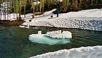 Montana Iceberg
 end of the line
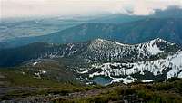 south bowls
 backcountry bliss
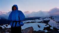 Stormy Summit
 wet dogs
 On 8241
 southeast ridge
 Teewinot waits
 lonely lookout
 climbing ridge
 east cornice
 usual shoulder conditions
 summit jerks
 Phil drops in
 Phil and Jay bomb it
 our primary descent
 Ski Bros (for real)
 west face
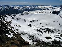 west bowl
 southeast bowls
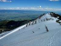 south bowl
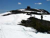 north ridge
 south bowl traverse
 south ridge traverse
 south bowl traverse
 Northeast bowls
  east bowls
  west face
 late fall
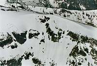 northeast bowl
 northwest exposure
 point 8672
Comments
Post a Comment