Days One and Two
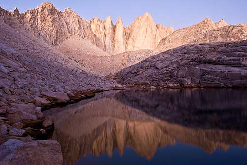
The Mountaineer’s Route is well known among peak baggers and my choice for this year’s entry into Sequoia National Park. The initial objective of photographing Mt. Whitney from the small lake below Thor Peak (Thor Lake) was to be followed on day two of this nine-day excursion with a climb over the Whitney-Russell Pass.
This year’s trip began under blue skies after parking near the trailhead at Whitney Portal, Oct. 8, 2009. I had hardly gotten underway when I came upon a party of several climbers, one of whom I was acquainted previously from the SummitPost website, a fellow poster who goes by the alias, Chief. It was Chief who first suggested Thor Lake as the ideal location from which to photograph Mt. Whitney. It is a small world indeed. We exchanged introductions, had a few good laughs, and I continued on my way.
The Mountaineer’s Route is well traveled. On some sections, the smell of human feces hangs in the air, presumably because not all hikers and climbers pack out their poop as required by the NP service. It is also a route well marked with cairns making navigation far less tedious.
Thor Lake is a beautiful location. At 11,600 feet, this lake provides an ideal perspective for capturing photographs of Mt. Whitney in the full glory of Sierra mountain light. Watching small birds scramble atop the frozen lake edges provided additional entertainment. One tail-bobbing species would actually dive underwater while foraging for food. It is amazing how they can keep warm in such frigid conditions!
The following day, as I headed towards the Whitney-Russell Pass, I felt good for having been in the mountains only 24 hours. I did get woozy when holding my breath as I framed one photograph after another, but otherwise, I was good to go. I even got a great shot of the elusive pika (also known as a cony) as he was making his way from field to bin with a mouthful of grass.
Upon clearing the ridge above Iceberg Lake, I sighted my targeted pass and dreaded what lie ahead as the entire east side appeared covered by hundreds of vertical feet of talus-strewn steep mountain slope. I hate scree and talus, enough so to avoid negotiating such terrain at the expense of climbing higher solid granite routes. Mistake number one: Better to not veer from a carefully planned course of action unless forced by circumstances beyond one’s control. One would think as frightened by heights as I am, I’d never consider going up the Class 3 deep couloir that separates the northeast ridge from the east buttress of Mt. Whitney. The solid granite was simply too inviting for my oxygen deprived logic.
Oxygen deprived on day two with 56 pounds of gear, I eventually made the top of the couloir. It was one to three steps at a time, huffing two breaths for each step, stopping for a minute or two between sets, and finally reaching the top of the notch at 14,000 feet. My progress was hampered by having to descend over two hundred feet from near the top of the couloir in search of my satellite personal tracker (SPT), which had become detached from my breast strap along the way! That was mistake number two, not having better secured this device. My SPT had suddenly become a liability instead of an asset. Had it not been found (consuming an hour’s time and precious water), the trip would have been over.
Three successful peak baggers descended the couloir as I neared the top. The strongest of the three, the first to reach my location, informed me that although it was steep going on the other side, descending into Sequoia NP was doable. The word, steep, was unsettling. Nevertheless, my new-fangled route became stoked with renewed enthusiasm.
Mistake number three: Carry plenty of water. Down to half a liter, I figured the going would get better as I would, after all, be descending. Easier said than done. Having reached the top of the couloir at 1:00 PM, the initial descent was very arduous for one burdened under the weight of a full backpack at 14,000 feet and yet to be fully altitude acclimated. Picking my way down the near vertical ledges, there were several moments I feared turning back would become the only option. I was feeling irrationally desperate while combating acrophobic demons. For 1.5 hours of scrambling along the cliff edges, I went one way, then the next, up and then down, and finally, I found my way out to the field of moraine below followed by a hoot joy of what was to become an odyssey like nothing ever before.
Wearily rock-hopping my way through the interminable moraine field, I reached the first lake at 12,400 ft. by 4:00 PM. After 8 hours of gaining under 2 miles, I slowly drank one liter from the lake and filled my bottle with another. Without any options for setting up my tent and desiring thicker air, I continued on my way in a near completely exhausted state. At 6:00 PM, I reached the western shore of Arctic Lake. It was all I had but to struggle in erecting my tent, crawl inside, and take a night’s worth of fitful sleep. I cannot recall having ever been so completely drained! I had no appetite and I was suffering early symptoms of severe indigestion. It was an extremely cold evening and Arctic Lake was living up to its name, as several yards of shoreline water froze overnight. I was uncertain about continuing with the trip.
![Pika]() Pika
Pika![Mt. Whitney]() Mt. Whitney Reflected within Thor Lake
Mt. Whitney Reflected within Thor Lake![Arctic Lake]() Arctic Lake Reflecting Mt. Hale
Arctic Lake Reflecting Mt. HaleDay Three, Crabtree Lake Basin
The following day after an easy eight-mile leg, I made my way into the Crabtree Lake Basin feeling 90% improved. Still plagued with indigestion, I took a dive into the freezing cold water for a refreshing rinse. Other than a few abrasions and bruises, I was uninjured. Drinking coffee the first morning at Crabtree, Oct. 10, caused pain to my inflamed lower esophagus. Managing only a small meal, I still had no appetite.
October 11 found me better rested. I enjoyed constant entertainment photographing the “Crabtrees” surrounding the 11,000-foot lower Lake. At sunrise, I composed some photographs of the Red Spur across the Kern River Canyon. Little did I realize how the red in those spurs would vanish within the next 24 hours.
Crabtree Lake Basin is beautiful. My pessimism to continue with the trip was diminishing as my appetite gradually returned and the heartburn subsided.
By midday, I wandered up to the middle Crabtree lake. At only 200 feet of gained elevation, the middle lake contrasts sharply for its lack of trees. I am always fascinated by the incredibly diverse transitions one encounters within the Sierra. These abrupt transitions are a large part of why I continue to return.
While standing upon the eastern shore of the middle Crabtree Lake, out of the absolute silence, I thought I heard the beginning of a rock fall. Looking to my right, I sighted six birds flying over my shoulder. It was their flying motion I was hearing! As they flew out over the lake, sunlight flashed in specular highlights from the backs of their wings. After reaching the lake’s opposite shore where the mountain began its abrupt rise, in a perfect V-formation, these six birds looped back around and came over my left shoulder. Their backs were brown and their bellies cream. It was a poetic moment.
I sighted the formation of mare’s tail clouds in the afternoon sky. The weather was about to change. I could smell it.
![Foxtail Pine]() Foxtail Pine
Foxtail Pine![Foxtail Pine]() Foxtail Pine
Foxtail PineDay Four... Heading Across the Kern River Canyon
Awakening the morning of October 12, my indigestion was nearly gone and my appetite had returned. It was time to cross the Kern River! The skies were overcast and not a puff of wind. While working my way along the John Muir Trail, I encountered a party of three hikers on day 32 or their JMT through-hike. They looked good and were full of smiles upon my congratulations. Their leader did all of the talking. We discussed their planned Mt. Whitney exit and I was informed of a weather advisory issued for Mono County, although with uncertainty as to the magnitude.
I continued down the Wallace Creek trail in my approach to the Kern River. The views across the canyon were stupendous! With the green and peach colored granite, giant junipers, distant Jeffery pines, fall colored aspen, slopes draped in manzanita and mountain mahogany; the sight of the Kern-Kaweah River drainage realized a long-planned trip coming true.
Upon reaching Junction Meadow at the canyon floor, the size of the Jeffery pines was overwhelming. It was yet another enlightening experience of abrupt transition in remarkably little space and time. At 8000 feet, the smell of fall was in the air and the oxygen refreshingly thick. Although tired, I was far from exhausted and could not resist pushing further up the Kern-Kaweah River drainage to my anticipated destination within the Kaweah Basin. It was 5:30 PM when I reached the Pickett and Kaweah Creek cascading fork at 9,200 feet; I found a suitable patch of level ground inside a small pine grove. The location would be ideal for a base camp from where I could extend day hikes into the higher reaches. Having erected my tent, I set out to photograph the sunset. I was camped near a cliff edge above the aforementioned fork with a view extending to the eastern Sierra escarpment! I had never before witnessed such massive lenticular cloud formations. I suspected I was on the storm’s edge.
![Giant Juniper]() Giant Juniper
Giant Juniper![Kern-Kaweah Drainage]() Kern-Kaweah River Canyon as viewed from afar.
Kern-Kaweah River Canyon as viewed from afar. ![Jeffery Pine Grove]() Junction Meadow and Jeffery Pine Grove
Junction Meadow and Jeffery Pine GroveThe Snowstorm
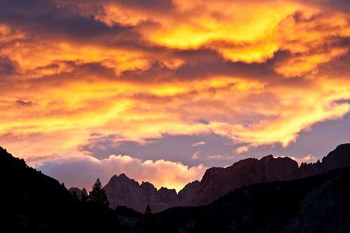
The following morning, Oct. 13, I was greeted with a blood-red sunrise. Then it began to snow. For over twenty unrelenting hours it snowed. There was absolutely no wind. After placing all of my gear within the tent, I stocked up on water. From 9:00 AM until 4:00 PM, I remained tent bound falling in and out of sleep. I exited the tent at 4:00 to activate the “Okay Check In” on my SPT and for the second time, I dug the snow from around my tent to prevent the walls from collapsing inward. I stayed focused on remaining dry and warm.
I dozed into a light sleep only to awaken with labored breathing around 1:00 AM. By now, my tent roof was reduced 50% in height under the weight of incessant snowfall. All ventilation had become blocked and everything outside my sleeping bag was wet with condensation. With a mix of rage and fear, I pounded the sides of my tent with forearms and legs, and I then sat up to dig a hole for ventilation through the tent vestibule. I remained awake the remainder of the night. I found I could dry my wet clothing within the tent by bringing the moist items inside my sleeping bag and using my legs and arms to affect a makeshift bellows. By doing so, I was able to stay focused on the task at hand without over contemplating my current predicament. For five hours, I found peace in drying my garments. Meanwhile, the constant pitter-pattering of wet snow had the opposite effect, as did the ever-increasing sounds of “snow thuds” from overburdened tree limbs dumping their loads. As often can be the case after foul weather prevails, I could only hope for hot sunny skies in the days to follow. Otherwise, I could not imagine finding my way 20 miles back from where I had begun. By now, I had accepted the possibility of a humiliating “911” call using the SPT. I even considered exiting the park to the West only to find my maps inadequate to the task.
![Flaming-Red Sunrise]() A warning of what was to come?
A warning of what was to come?Snowbound
At 6:00 AM, Oct. 14, I exited my tent as the sound of falling snow began to diminish. To my dismay, the skies remained clouded, but the snowfall was now intermittent and light. It did appear the storm was near its end. I again exited at 9:00 AM to partly cloudy skies with the much hoped for rays of sunshine, and by 10:00, the skies were mostly blue. The landscape had been transformed. The world was white. The cascading creeks were now torrents of greenish turbid water. After draping all of my gear outside the tent to further dry, I prepared a hot meal and contemplated what lie ahead.
It was around 11:00 AM, a helicopter flew through the canyon in what appeared to be a search mode. I figured they were looking for me but was ignored when well within their sight. Anticipating a possible rescue, I prepared all of my now dried gear for a quick exit with the exception of dismantling the tent. The helicopter did return, but the pilot continued to ignore my obvious presence as I had now draped a space blanket around a nearby stump of a tree. I had carried this blasted space blanket with me for my past twenty-something Sierra excursions. I was glad to finally put it to use, although reality was to later prove the effort futile if not foolish.
By 3:00 PM, it was evident no rescue was likely. I returned all dried items to my tent and figured I had little choice but to stay put and enjoy the view. I could not ask to be stuck in a more beautiful location, far more beautiful than any I had ever before experienced. The creeks began rising as the day rapidly warmed and the snow continued melting. The roaring cascades grew louder. The thought of flooding seemed less than a remote possibility except for the surrounding flora showing no past evidence. A brief excursion from camp revealed no trace as to where the trail remained hidden beneath what measured to exceed a foot of wet, heavy snow. With nowhere to go, I got out my tripod and camera and proceeded to photograph as the sun began to set. The beauty of it all is beyond description.
![Lenticular Cloud Formations]() Massive Lenticular Cloud Formations
Massive Lenticular Cloud Formations![Kern-Kaweah Canyon Walls]() Kern-Kawahea Canyon Walls
Kern-Kawahea Canyon Walls![Aspen Turning Color]() Kern-Kawahea Canyon Aspen
Kern-Kawahea Canyon AspenThe Exit, Day Seven
The following morning, Oct. 15, I was determined to make an attempted exit to the east. I took my time allowing the now hot sun to continue a much needed melt. No longer interested in the occasional helicopter flybys, I broke camp at noon and began my descent without first scouting the situation. I was going to attempt exiting regardless of what I found and what I found was a surprising relief. I had before me the tracks of deer, bear, and cat leading down the canyon of this now winter wonderland! They could easily find the trail otherwise invisible to me until I began to study the land myself and see the logic in their navigation.
As I neared Junction Meadow, I came upon two men headed up the trail conducting a search and rescue for a party of three that had gone missing since the day of the storm. It was then I realized my folly surrounding the helicopter flybys. But I was on my way and feeling good about what I figured to be a three-day effort to extract myself from this never ending challenge. Fording the Kern River was not the obstacle I had feared, the waters only slightly higher than when I had entered. I figured all of the cascading water coming down the mountain, dry only two days previously, was getting sucked below ground. These mountains are giant sponges and the relatively low level of the Kern River was impressive testament.
At Junction Meadow, I picked up footprints of what appeared to be two people hiking up the Wallace Creek Trail. It was evident the second person was walking within the footsteps of the first. Upon reaching the JMT, I established camp south of Wallace Creek, my first ever experience of setting camp on snow. I had a bit of extra food and loaded up my carbohydrate reserves as best I could manage. My goal the next day was to make it over the shoulder of Mt. Whitney and set camp somewhere on the other side.
![Kaweah-Picket Creek Cascading Fork]() Gentle Cascades Became Raging Torrents
Gentle Cascades Became Raging Torrents![Nature s Fine Art]() Kern-Kaweah Canyon Wall
Kern-Kaweah Canyon Wall![Above Wallace Creek]() Near Wallace Creek Campsite
Near Wallace Creek CampsiteExit Continued, Day 8
October 16 had me awake at 5:30, my wet soggy boots frozen solid. It took 2.5 hours to break camp and be on my way. As my boots melted and I made my way forward, once again, I came upon the tracks of two people. The snow went from hard crust supporting my weight, to mid-calf post-holing crust, to wet slush, depending on the location. As the morning wore on, I came upon the couple ahead of me. They, too, were attempting an exit over Mt. Whitney and welcomed my presence. We talked briefly and they were more than happy to have me proceed ahead at my faster pace. We were at the time within half a mile of the Crabtree ranger station (now abandoned until the following season). I no longer had the benefit of animal or human tracks to follow, but I could follow the lay of the land, my GPS, and the slight depression in many locations defining a well-beaten trail otherwise hidden beneath snow. Although the going was slow, I had plenty of water by eating snow at every opportunity. I found the snow not only adequate hydration, but also cooling to my perspiring body as I labored under the hot sun and blue skies. My progress went reasonably well until I reached above Timberline Lake near 11,200 feet where the snow became prohibitively deeper. The occasional animal tracks were no longer a benefit as my post-holing reached beyond mid-thigh. Coming upon Guitar Lake, I realized getting over the shoulder of Whitney would not be possible and settled instead for the base of the switchbacks below Whitney for the day’s destination. I climbed and navigated granite outcrops wherever I could manage as going over the snow was like going through quicksand. After 8 hours of plodding through unbelievably difficult terrain, I did reach the switchbacks to find a dry campsite that someone must have established during or before the storm as their tent site remained on dry ground! It appeared to have been a party of two or three that I figured possibly to be the JMT group I had met prior to descending the Kern River Canyon four days previously. It was a comfort to finally see human tracks once again. I could only imagine my final day would be better.
Ted and Jennifer did catch up to me (we will be forever friends). I could not imagine they would make it this far, but there they were, some two hours behind looking weary but fit. It was the first time in all of my Sierra excursions I welcomed company. At 12,000 feet in this enormous basin formed at the feet of Mt. Whitney and Mt. Hitchcock, it was a spooky and foreboding atmosphere. I never experienced that sensation before while camping in the wilderness. Not only did Ted and Jennifer provide comfort in their company, they also provided some energy bars to supplement my near empty food supply. Everything seemed good for our final push the following day with the exception of our boots that were soaking wet and would freeze solid overnight.
![Timberline Lake]() Timberline Lake
Timberline Lake![Timberline Lake]() Timberline Lake
Timberline Lake![The Red Spur]() Red Spur gone White
Red Spur gone WhiteExit Continued, Day 9
We broke camp at 7:30 AM, Oct. 17. It took fifteen minutes to put on my frozen boots and they did not release their painful grip on my aching feet until well over half an hour of pacing back and forth.
For the first two or three switchbacks, we followed the party that had exited a day or two previous to our attempt, but then their footprints vanished as they chose to climb the granite outcrops as an alternative to the apron of snow, now frozen hard on the surface, completely burying the steeper sections of switchbacks underneath. To attempt following the trail of switchbacks exposed one to the frightening possibility of slipping on these exceedingly steep and snow-aproned slopes. One slip and the trip would be over. We needed crampons and ice axes, but all we had were frozen boots and a desire to be on the other side.
As agreed prior to embarking on this final day, I left Ted and Jennifer to their own after an hour or two of staying within sight or earshot of one another. Their climbing below me was met with the possibility of rock fall, and my staying below with them could become compromised in conflicting efforts to achieve a consensus. After proving their determination the day before, I was confident Ted and Jennifer would succeed.
Clinging to the side of a steep and snow-covered mountain, kicking footholds through the ice-hardened crust, taking it one short section at a time, I never looked down. It took five hours to reach the Mt. Whitney Summit Trail. Upon my first sighting of people, I finally felt I was safe. Most of the dozen or so climbers seemed indifferent to my presence, but one fellow took interest and I briefly shared my saga. Others listened as he offered his congratulations and told me the going down would be fine. I was almost too weary to be happy. I just wanted to be in my car.
It was fortuitous being a Saturday. Weekends bring hoards of people to Mt. Whitney and their beaten path in the now soft snow on the other side provided both security and speed. It took only 3.5 hours to travel the remaining 8.5 miles to my vehicle below.
I checked with the Lone Pine NP Visitor Center first thing the following morning to confirm Ted and Jennifer had made it out. They, too, had a SPT, and with no reports of rescue, I was relieved to know they must have succeeded.
I survived an experience surreal beyond my comprehension. I witnessed change like never before. I’m less proud than I am humbled. And I got some GREAT pictures!
![Mt. Hitchcock/Guitar Lake]() Guitar Lake
Guitar Lake![Near the Mt. Whitney Trail]() Mt Hitchcock
Mt Hitchcock


Comments
Post a Comment