
Comments
No comments posted yet.
|
|
Trip Report |
|---|---|
|
|
19.41284°N / 98.71178°W |
|
|
Jan 5, 2021 |
|
|
Hiking |
|
|
Winter |
When I was waiting the bus to CDMX, in Oaxaca City (1500 msnm aprox), I never imagined that I would set foot above 4000 meters above sea level in less than 24 hours. Since a month before, my holidays were in the Itsmo de Tehuantepec, just above the sea level. My lungs, possibly, would not have the neccesary capacity to operate in the great volcanoes of the central Mexican portion. Anyway, I left Oaxaca at midnight, to arrive in Mexico City at dawn. All night long, I was reading the glorious attempts to reach the 8000's in last century, inspiring me to reach the highest peaks in the country. When I arrived to the bus station (TAPO, in the east of CDMX), I took another bus to Texcoco. Arriving there, the easiest option was to order a taxi to take me to my room in Chapingo, 20 minutes away.
As soon as I entered the room, I prepared myself wearing climbing pants made of ripstop, and casual boots. The shoe decision, despite being the only one available, resulted in walking difficulties and pain at the end of the day. It was a cloudy day, with 17°C measured by the themometer of my clock at 9 in the morning. I guessed that, if I reached the summit, it would be cold, although not as cold, maybe 10°C cooler than at time. Honestly, with the six hours that I had calculated from Ixayoc to the summit, it would be not be neccesary to carry a lot of coat, but for any inclement weather, I took a camisole for temperate weather, and a M65 field jacket, both of US Army Surplus. To eat, I only kept toast and a chocolate. Two liters of water were brought in two canteens. The scholar backpack was generously packed, more air than real hiking gear. To navigate, I consulted the routes at mountaineering sites, and used them on Google Earth. But, when the battery of my smartphone ran out, the use of topographic charts prepared by INEGI, in addition to a engineering compass would be decisive, since the telephoine signal is non-existent most of the way.
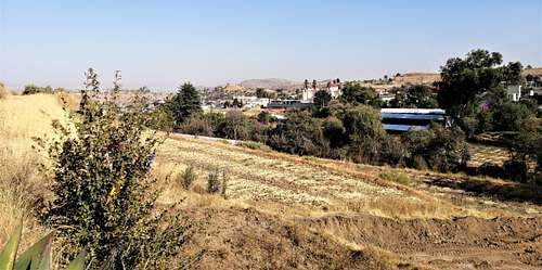
Impatient, I went to the main entrance of the Chapingo University, to wait for the transport that was diverted to Tequexquináhuac and San Pablo Ixayoc, both agricultural communities. Half an hour was how long the transport took to drop me offat the least stop. There was a large radio telecommunications antenna, next to a store and restaurant, which were even more noticeable than the climb to the "El Cedral " ecological park, another place to watch beatiful landscapes. The road to the Izta-Popo National Park wound with a trend towards the south and the hills full of agricultural terraces in the same direction.
At 10 am, I was paying my ticket in the ranger's office ($10 mxn). He told me that I was already late if I wanted to reach the summit and return before dark. Due to my inexperience, I ignored the warning, wishing him good morning. Then, I walked quietly following the aquaduct, resulting in a beautiful path through an oak forest that shares land with corn and other cereals fields. At the altitude of 2800 m, the oak forest quickly became a fir forest, where the oyamel is the dominant tree, iconic for the conical shape of its cup. The aqueduct ran parallel to the dusty road for cars, bikes and racers. In this section, until the prelude to Cerro Tearco, the slope was less than 15°. However, at the base of Cerro Tearco, I was hiked around 5 km. Next, was one of the more vivid dream between mountains and the vegetation in his soils.
Until then, I had met only two or three people on the road, greeting them briefly. The best thing was to keep your distance, both because of the threat of SARS-COV-2 and because of the clouds of dust that, at the slightest step, rise. Also, I noticed that my steps were faster than average, making rapid progress. I didn't drink much water, and my spirits rose with elevation, an equation that would quickly become invalid. Cerro Tearco made an appearance with the rapid meandering of the aqueduct now on a steeper slope, with signs of water runoff making clear erosion in narrower paths. This humidity, as well as the higher density of the forest, and the term of permanent human influence, were related to the higher plant density.
The slope reached 25 ° on some steep slopes. There were numerous curious sites that deserve to be mentioned as reference points. I do not know if they were problems of erosion, or the need for mountain bike paths, but part of the path was delimited by dikes and rows of sacks filled with sand and earth, which could retain the soil that was dislodged with the frequent steps of people. In addition to the aqueduct, always parallel to the road, the existence of a piped water network, of little capacity, was clear; At some points, the noise of the water in some vent surprised me, because the tranquility reigned together with the singing birds, and the soft gusts of wind that made all the trees of those infinite forests dance, in a single outdated measure. One of the most peculiar scenes was that of a succulent (a crassulaceous) stretched out on a rock, as it looked like a huge desert plant, in a humid forest. Solitude did not exist, when admiring the landscape while monitoring the changes in atmospheric pressure and temperature. I lost my breath from the effort of the climb, but in one-minute breaks I quickly recovered. The fact that the sun was moving towards the zenith did not prevent the temperature from decreasing very gradually.
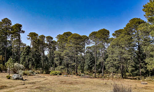
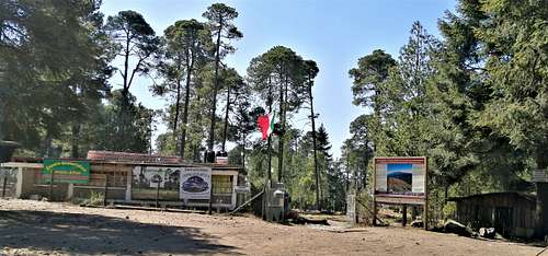
It was around 400 meters of vertical distance that were consumed on the slopes of Tearco, but they were enough for the environment to change again. This time, it was the pine trees that made an appearance, only a few, but their dominance would increase with altitude, displacing the fir. I will describe that enchanting forest later. The steep climb had led to an almost flat path, which passed through a small body of water, something like a small cistern in the middle of the aqueduct. Then the pine forest really began. These trees, the pine of the heights (Pinus hartweggi), have a particular physiognomy, mainly due to the fact that, when they form a forest, the crown of each individual is limited to a small area in the upper part, like the araucarias of the south of Chile, and its clean trunks allow a deeper visibility of the environment, although the understory was now populated and competed by more showy species. Plants with many flowers of an intense purple color (Lupinus montanus) stood out. The trail went through a wide clearing in the middle of the forest, which looked great for camping. From that place, it would perhaps be a kilometer to reach Canoas Altas, an ecotourism center where I could see cabins in the distance.I decided to take a break on a rock 50 meters from there. I drank water, ate some toast, and analyzed the situation at the time. It was exactly noon, that is, it had been two hours on the road, and according to what I remembered, this park is located at 3,500 meters above sea level, in a small valley between several mountains.
They added 900 meters of vertical distance ascended. In that place, there was a sign announcing the entrance to the Izta-Popo National Park, which includes Mount Tláloc and Telapón, as well as all its subsidiary peaks. Tlaloc and Telapón make up, mainly, the Sierra de Río Frío. Next to the sign, the path I had followed forked into two main options: one heading east, and the other heading north into the forest. Although there was surprisingly little cellular signal reception, the maps were not loading, so the path on Earth was just a line, below which the satellite image was not visible. It was a difficulty that was solved using the INEGI topographic chart at 1: 50000 scale, and the compass application of my smartphone, which apart from measuring the azimuth, showed the geographical coordinates of my position in degrees, minutes and seconds; It wasn't much precision, but it was totally acceptable, and depending on the route I had planned, I had to keep going north. Thus, I was georeferencing my location on the map manually.
The path I chose quickly curved up and up slopes of many different levels, though never steep. It was a difficult dirt road, yes, but more for the distance that the feet traveled apparently far from the top, it was actually still very far.
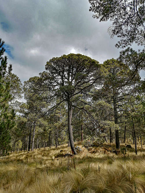
At some point, the end of the forest and the farmlands were seen to the west, far away, until the silhouette of the CDMX was seen, very faint due to the smog. This dirt road was wide, designed for the passage of 4x4 vehicles. It ran through cuts in the hill, which was clear because at waist height, or higher, were the dense root systems of tall grasses, which in Mexico are called, as a type of vegetation, "Zacatonal" , which changes its biological composition as the altitude increases, reaching the alpine meadows above 4000 meters above sea level. But, long before that, exhaustion was starting to slow me down; time seemed to run faster and I was moving fewer meters. To top it all, the rock formations were on the rise, testifying to the more recent volcanic activity. There were numerous hills and minor elevations in any direction, very occasionally there were depressions that widened deep into the intermountain valleys. In any case, the reference points were more difficult to locate, and with them the course, since the roads frequently forked and lost a few meters. The forest at that point was very similar, it was semi-open; the trees, usually so similar to each other, began to adopt strange shapes due to various damages and phenomena, such as violent winds, forest fires and pests. The latter came out like parasites from the branches and trunks, giving it a spectral touch. That said, it is easy to understand the times I got lost, reaching false peaks, one of which offered me the first view of my life to Telapon, far away, but below a vertical wall fell, approximately 20 m, that however it could be skirted (but at that moment, I didn't see the need), but recovering the course with the compass and the chart, I changed direction towards other ups and downs. The most difficult point of my ascent was overcoming an unevenness of almost 100 m between some huge stones, which although it was not technical, was heavy due to the accumulated fatigue up to that moment, and the wrong choice of footwear, since my shoes were made of a flexible sole, more for a rural walk than for an authentic mountain, or volcano, in this case. Of course, the rock was volcanic, hard and smooth.
When I came to a clear space in the forest, completely devoid of vegetation, and on the edge of a rock, I realized that it was another important landmark, where there were even small logs to sit on, and a dedicated site for bonfires. By then, with fatigue concentrated in my legs and feet, I decided to take another break, to analyze the situation, and perhaps return, because with such effort I could not imagine that I would have to return on that path that I had so hesitantly traced. However, I saw that I was in the final stretch of the road, that I would continue next to a large rock, "a rock", as they say in Mexico. I would need 200 meters of vertical distance to get there, maybe another kilometer and a half, maybe two, to reach the summit. It was two in the afternoon. The night before I had made calculations based on my meteorology class, to see how long that day would last, and especially when the sun would set. Most stupid of all, my calculation had been fine ... for a day with daylight saving time. The sun would actually set at 6:15 pm, when I had calculated the end of twilight at 7:20 pm. I thought it would take another hour to reach the summit, and I would return at 4:00, to have about 3 hours for the descent, more than half that it would have occupied in the ascent. It was Tuesday, so I was hoping to still find public transport back, as taxi services do not reach isolated places, and they were quite expensive anyway. I decided on the rest of the ride at that point. I started the final stretch.
My feet ached more and more because the ground was reducing the area it occupied compared to the stones, sharp and obtrusive. Apparently, it is a field of debris, the results of weathering on the lava flows and stones that the volcano expelled tens of millennia ago. The forest had vanished from where it had last rested, being replaced by the alpine zacatonal. The plants were tall and dense grasses, which covered the entire space under them, the tallest reaching a meter in height. The sun, in those hours of the afternoon, was somewhat hidden in the clouds, but its rays made the scene look like one of the Elysian fields, with golden pastures, and a path of dark sand, with stones, in the middle, very well delimited. I had reached 4000 meters above sea level in half an hour, and in another half the 4120 meters above sea level, which has the tenth highest mountain in the country as a total elevation.
In this way, at very forced marches, but without altitude sickness, I made out two parallel stone walls. First small, their size increased dramatically, like the amazement and admiration of my entire being. If ascending to this site had cost me, until then, the greatest effort of my life, what would it be like to organize a group, perhaps an army, of people, to build a temple of that size at such an altitude, with that isolation? Was it faith, fear, or spiritual need that motivated those Mexicans? Naturally, a judgment can be passed when a question is asked, and confessions can arise in a judgment: I had been guided by curiosity to know, and also to take the body to the highest mountain to which at that moment I could aspire, as initiation.
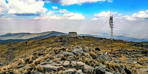
However, I have not been the only one, nor was I on that day. Before reaching the summit, at two thirty in the afternoon, I met a couple of men descending, who greeted me cheerfully and honestly. Walking in the middle of the ruins of that temple, I began to hear murmurs. I had been smoking cigarettes carefully, ever since I arrived, to calm myself and help me collect my thoughts. Then I saw a small group of mountaineers observing the compound, but we only exchanged greetings when I left the temple, an hour after I arrived. I can assure you that, for the first time, I took advantage of the achievement. As attractive as visiting the temple, I was made to walk around the astronomical observatory of the UAEM (Autonomous University of the State of Mexico), to see if it was working. The building was surreal for its architecture and the arrangement of the rocks, as it managed to blend perfectly with the landscape, but inside it was abandoned and in dire conditions. Perhaps it was a haven of last necessity, but the bottles of alcohol were suggestive.
Therefore, my stay there was shortened. After carefully observing the antenna that had been installed on the summit, I made my way to fulfill my last objective. I wanted to locate, from that point, the Nabor Carrillo dam, which indicates the direction of the metropolitan area of Mexico City and Texcoco. To the south, high mountains were visible, which at that time I could not fully identify due to my inexperience in navigation, the advent of clouds and the lack of a better technique in remote sensing of the route. To the east, in such a luminous way, the panorama that ranges from the towns of Nanacamilpa and Calpulalpan (in the plains of Apan), to the lands of Puebla. I knew that, on clear days, you can see the great peaks in the center of the Volcanic Axis, but the cloud cover prevented me from seeing them. Check out the photos of the panoramas from the summit to get an idea, with the best resolution and settings I could get.
The clock read three in the afternoon, and 8 ° C when I stopped at the entrance to the temple. When I took the initiative to go down, it was close to four in the afternoon, and the temperature dropped, sensibly, to 6 ° C, which felt light despite the wind, because with the effort and the coat, the cold had no effect . I said goodbye to the mountaineers, I saw the slope and the path I had traveled. The blood on my back cooled rapidly, but my hot legs supplied it with enough heat to lower it. The other half of the story began.
Going down, I spotted a possible easy climbing route half a kilometer away to reach a subsidiary summit that blocked my view of an important part of the Valley of Mexico. Again I admired the dwarf pines, and their cousins, Juniperus, creeping. I had no food left, I finished my chocolate at the top. The remaining water, less than a canteen, became an incipient concern. I came down quickly for a good stretch, getting the view, from a new perspective of the forest, rapidly changing. The light revealed many logs of singular beauty, and the humidity increased as dusk fell. The sensation of witnessing how the light diminished, at an increasingly alarming rate, cast doubt on the criteria, for the first time, that had improvised (that's how I understood it then) the trip. That doubt prompted new decisions, fueled by incomplete knowledge and understanding of the terrain on which he walked. At the end of the heavy descent, which had previously meant the most difficult climb, I rested and drank enough water to clear my throat and moderately moisturize my already ruined lips. I started taking improvised shortcuts that made sense to me given the direction I was pursuing, very much based on the path of the sun. I used the first shortcut, it worked. The second time, unfortunately the trail forked, and the wrong decision made me go back and correct my course, wasting valuable minutes, and sapping my morale. At the time, I don't know if I really heard the female voices with a male one that I greeted back, maybe I did, since I had lost myself.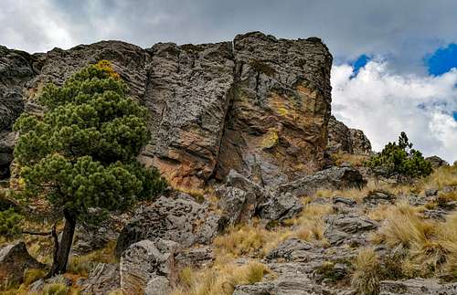
I became aware that I was already the last person on the mountain, the one who was in the deepest part of it, and alone, unlike all the people I met. He had to try, again, and with resounding success, a shortcut. I was somewhat reassured by the fact that I was ultimately on a mountain, and the downward slope, on the descent, would help me gain speed. The polyline that I followed with my archaic method of navigation, clearly described a huge curve in the section that followed a few meters below me, and if I managed to cross a shortcut, I could really buy a lot of time. I slid down the first path that veered off the curve and into a straight direction, down the slope. It would result in a resounding error. I was not completely unaware that the zacatonal was a fairly dense type of vegetation, and half a year later I would realize the works of supposed water capture in the forest. At that time, he only understood that some unfortunates had dug trenches or trenches in the zacatonal, approximately 50 centimeters deep, 40 wide and perhaps a meter, or a meter and a half long. He had chosen a somewhat steep incline, playing the opposite effect to what he wanted. My steps had to be much more careful, and the shoes had lost what little they still retained of dignity and comfort, for they were filled with dirt and dry fragments of long, sharp blades. Falling into a trench meant taking your foot or both feet out of there, hampered by the grasses that claimed their territory, frequently resorting to the use of your hands. It was more effort than I had planned, and the few centimeters that my mind thought that I had strayed from the route were actually tens of meters, which at a critical moment forced me to pass under a fence made of logs and barbed wire.
Shortly after, I found the dirt road again, and my morale increased, because I knew that it would take me straight to Canoas Altas, and from there I would not detach myself from the aqueduct. In Canoas, it was 5:30 in the afternoon, and the sun was alarmingly under the canopy of the forest. I wanted to rest, I needed it, but I no longer thought twice, and I advanced as fast as I could, but the loss of speed was inevitable, because the support of the footwear was almost non-existent for the slope and the ankles swinging on the bumpy road. I put some music on a headset, something about a tunnel, not in the middle of the dark, damp forest, but a tunnel in the warmth of loving feelings.
In the dark, a pile of wood obtained in a sanitation disoriented me, diverting me from the route. Thus, and with the slippery slope that skirted Cerro Tearco, I was descending, risking my lower extremities a little in some jumps. I was able to afford it because the water was almost completely used up, and I became coldly aware that my calculations had failed. It no longer mattered if it was an hour or more, he wanted to get to Ixayoc before eight at night, as a hope of finding transportation. It was an effort that became more desperate, and neither was time in my favor. Before reaching the base of Cerro Tearco, the sun had already disappeared, and my steps had become clumsy, losing their technical ability, only retaining the ability to advance and stop slowly, fueled more by my anguish than by my energy. On the shallow incline section, I walked fast. For an hour the cell phone battery had been under 20%, and the use of his flashlight was now essential. Seven at night arrived, and the night had already been fully established, for a long time, but now, at the exit of the forest, in a section without much vegetation, about a kilometer from the ranger's office, the image appeared to me From the billions of lights of Mexico City, far, far away, I separated from the closest cluster of lights, a huge hill and a path of dry trees. The last time I had seen the CDMX from above, it had been in my adolescence, returning by bus from Puebla, then I was with my parents, and on an expedition from their work, so I was sure. At that time, I could not guarantee my own safety. Near the office, there were several tents installed by various mountaineers who wished me a good descent. They really reassured me.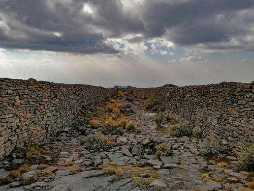
The unpaved street that connected civilization wound tediously around the sides of the isolated houses on that last hill that descended. The dogs were already threatening me with their barking. I got to the lower part of the hill, and to the town at last. I walked up the street to the bus stop, and waited for a transport to arrive. It was already a quarter of an hour to eight at night, and I waited for eight to start walking, with all the weight of my heart, to some town miles away to locate a transport. Fortunately, a suburban transport arrived, an urban one, to load passage. From the emotion, and thinking that I could not go wrong now, I took it, along with other people. Unfortunately, it took a route that I did not know, and I realized that it was heading to the center of Texcoco, diverting me about 5 kilometers from where my room was, to lie down to rest and think about what I had done.
In the end, I got off, took one last ride, walked the last mile to the room I rented, and lay down on my bed, drank water, ate some bread, and I could finally feel that it was all worth it. I was mentally worn out, but the photographs that remained as evidence motivated me to start expeditions to the Mexican mountains, with an emphasis on the 10 highest. In this case, I had overcome a positive elevation gain of 1600 meters, walking a horizontal distance of approximately 28 kilometers.