
|
|
Mountain/Rock |
|---|---|
|
|
31.90634°N / 107.70383°W |
|
|
Luna |
|
|
5630 ft / 1716 m |
|
|
Overview

South Peak, also known as South Sister, has an elevation of 5,630 feet and a prominence of 600 feet. It is the southernmost summit of the Tres Hermanas (Spanish for “Three Sisters”) Mountains, a small range in southwestern New Mexico. The summit lies about 6 miles north-northwest of the small town of Columbus. South Peak’s immediate neighbor is Middle Peak (or Middle Sister, elev. 5,786 ft.) to the northwest, while North Peak (or North Sister, elev. 5,802 ft.) is situated further northwest at the other end of the range. These pyramid-shaped peaks, lined up in a northwest to southeast orientation, are quite prominent when approaching from the north on New Mexico Highway 11.
Seemingly endless views await you at the summit, even if you go to the wrong one! The wide-open Chihuahuan Desert terrain spans the surrounding region. Numerous mountain ranges can be seen to the west; Big Hatchet Peak, one of New Mexico’s most prominent, looms large in the distance. To the east, the landscape is dotted with the ancient volcanoes of the Potrillo volcanic field. The Florida Mountains lie to the northeast. The communities of Deming to the north and Columbus, NM and Puerto Palomas, Mexico to the south can also be seen from the summit.
 View from saddle. View from saddle. |
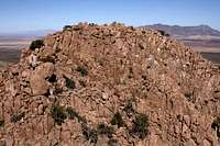 South Peak’s summit. South Peak’s summit. |
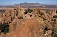 View from summit. View from summit. |
Columbus, New Mexico
Columbus is a small town 3 miles north of the United States-Mexico international border. This town captured the attention of the nation after 500 Mexican rebels, under the command of General Ramon Banda Quesada and on orders of revolutionary leader Francisco “Pancho” Villa, crossed the border into the U.S. and raided the town on March 9, 1916. There were 24 U.S. casualties - 14 soldiers and 10 civilians. In addition to the human toll, the town was set afire and suffered significant damage. Villa’s force suffered 80 casualties.Getting There
Exit Interstate 10 at Deming, New Mexico and proceed south towards Columbus, New Mexico on NM Hwy 11 for about 24.1 miles. During this leg, aside from seeing a lot of green and white U.S. Border Patrol vehicles, the “Three Sisters” -- North, Middle, and South Peaks -- will be in plain view ahead of you. You should see a dirt road to the right (North Peak will also be to your right) with a green metal gate. Do NOT turn here. Proceed about 2.5 miles further south from this road and there will be another dirt road, this one without a gate. If you get bored or tired, try counting the Border Patrol vehicles (it’s better than falling asleep at the wheel)…but don’t miss your turn!Turn right here and reset your odometer. NOTE: The intersection for County Road B-005 is opposite NM Hwy 11 from the dirt road where you will turn right, so if you see the CR B-005 marker, you’re in the right place.
- Proceed west on the dirt road towards the Tres Hermanas Mountains. At 0.4 miles on the dirt road, the road will split. Veer to the right (left goes to private property).
- At 1.3 miles, veer to the right.
- At 1.6 miles, the dirt road splits but merges after a short distance. Veer right at this split as the left side is very rough.
- At 1.8 miles, continue straight through the intersection and head directly for South Peak. Park at the base of the mountain.
NOTE: There are a couple of areas of the road where high clearance is necessary. Also, there are areas of deep, loose dirt and sand where 4WD might be required to negotiate.
Route to Summit
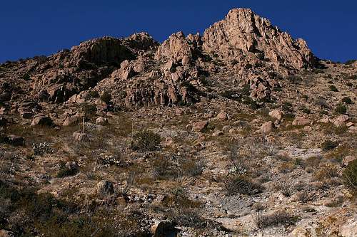
As typical of just about every summit objective, gaining South Peak is not as easy as it might appear. If you’re looking for a “safe” summit, I would recommend against attempting South Peak. Everyone has their own perception of what “dangerous” is, and although South Peak lacks the exposure, in my opinion, to be considered overly dangerous, it is not “safe” by any stretch of the imagination.My route was up the east slope and nearly the entire route, with the exception of the beginning, was chock-full of route-finding, bushwhacking, rock-hopping, and scrambling. And, of course, cacti avoidance was a challenge. I did not see any trails, faint or otherwise. South Peak has a double summit. It can be difficult to determine which of the two is higher, so I’ll make it easy to prevent others from making the mistake I made of going to the wrong one. The true summit is the one to the right, or to the north. By my GPS altimeter, there is only about a 10-foot difference in elevation between the two. As you ascend, shoot for the saddle between the two summits, then ascend the actual summit on its south side.
NOTE: Although there are no active mining operations in the Tres Hermanas Mountains today, there remains vestiges of past mining activity. There is an open entrance to a mine shaft in the early part of the route near the end of the 4WD road. There are probably other mine entrances and ground openings which pose obvious hazards, so please be aware of these and remain clear.
From what I could see, the east route seemed to be the only navigable route to the top. Once on the summit, however, it appeared that approaching and gaining the summit from the north side might possibly be safer. Not being able to clearly make that determination though, I decided to descend the same route I ascended, on the east side.
The east route is about 0.7 miles one way with 1,170 feet of net elevation gain.

 Route view 1. Route view 1. |
 Route view 2. Route view 2. |
 Route view 3. Route view 3. |