
|
|
Route |
|---|---|
|
|
43.83270°N / 114.5181°W |
|
|
Scramble |
|
|
Half a day |
|
|
Class 3 |
|
|
Approach
After taking the left fork on the Boulder Creek Road, the road will climb high onto the basalt flows from the peaks above.
The road gradually deteriorates in condition and a four-wheel drive vehicle will be needed. At 8,200', the road will abruptly end in a thick evergreen forest.
 |
Route Description
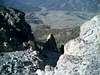
From the end of the road, climb directly northeast through the steep evergreen forest until gaining Boulder Peak's south ridge roughly at 9,300'.
Turn north on the ridge and begin scrambling up the loose rock until encountering a tower that blocks the route. Drop to the west side of the tower and conour around the base until coming to a prominent gully that climbs back to the south ridge above.
After gaining the ridge once again, scramble northward until reaching another impassable tower. This time, drop as much as 70' below to the southeast face. Work across a a ledge system and some minor class III climbing until reaching one more gully that returns to the south ridge.
From this point, it is a short and beautiful walk to the summit.
 |  |  |  |
Essential Gear
A four wheel drive vehicle and prior scrambling experience is all that's needed for Boulder Peak's South Ridge Route.