
-
 3977 Hits
-
 71.06% Score
-
 1 Votes
|
|
Route |
|---|---|
|
|
44.23083°N / 10.42532°E |
|
|
Hiking |
|
|
Spring, Summer, Fall, Winter |
|
|
Half a day |
|
|
Hike |
|
|
Overview
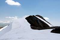
 Monte Cella from Costa i Roncacci Monte Cella from Costa i Roncacci |
The south route to Monte Prado, which passes to the east of Monte Cella and Monte Vecchio, is a long hiking route along the highest ridge of Toscana (Tuscany). It follows the main ridge of the Appennino and thus the border between Toscana and Emilia Romagna. The first part of the route traverses a dense and dark forest with little to see but above 1700m, when you reach the little Rifugio Cella, you pass the timberline.
There are two possible ways to reach Passo Bocca di Massa, one starting at Passo delle Forbici and one at the small hamlet (ski area) of Casone di Profecchia. The hike (ski tour) from the latter trailhead is described here.
Getting There
The Casone di Profecchia are located a few km to the west of Passo delle Radici on SS324. The main page describes the itineraries.Route Description
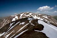
 On the east ridge of Monte Cella
- Start altitude: 1314m
- Summit altitude: 1942m
- Prevailing exposure: South and West
- Type: Easy, steep grass ascent to Monte Cella
- Protection: None
 |  |
From the parking lot at Casone di Profecchia cross the road and head for a small staircase to the left of the restaurant. It leads to a small ski lift. At the lift turn right into the dense fir forest and follow the signs, which lead steeply up the slope. The path touches upon the higher outskirts of the hamlet before switching back and forth towards a first ridge. You will find a dirt road which you have to follow to the north. The hiking trail cuts short several of the bends of the road before finally joining it just short of Rifugio Cella, a small hut located on the Costa i Roncacci Ridge.
 |  |
At the rifugio turn right and head up the pasture until you attain Costa i Roncacci. Pass to the far side of the ridge (huge cairn!) and follow the pass to Passo Bocca di Massa. Here the route from Passo delle Forbici joins from the right. Turn left (signs to Monte Prado) upon a clearly marked path. After a few hundred metres leave the path and head up the east slope of Monte Cella instead. The slope is steep but can be climbed without further problem.
 |  |
Descend the north ridge of Monte Cella, which soon joins the regular trail for Monte Prado again. Follow the trail to the base of Monte Vecchio, where the same ritual starts. The trail passes the mountain on its eastern side. Leave the trail and follow the south-east ridge of Monte Vecchio instead. It is longer and steeper than the east ridge of Monte Cella and even a bit exposed in its topmost part.
 |  |
Again descend by the north ridge. This ridge also is much longer than the Monte Cella north ridge. Its topmost part is narrow but it soon turns wide and heads for a wide saddle at the base of Monte Prado. A bit before the saddle the hiking trail joins again and together they climb the south ridge of the mountain. The path winds its way along the ridge to a first summit, then crosses the wide summit plateau to the main summit on the far northern side.
In winter the route is often done as a ski tour.