
-
 7304 Hits
-
 81.84% Score
-
 14 Votes
|
|
Route |
|---|---|
|
|
34.48277°N / 119.7145°W |
|
|
Hiking |
|
|
Spring, Summer, Fall, Winter |
|
|
Less than two hours |
|
|
I |
|
|
Overview

Although there is at least one other alternative route to gain the summit of Arlington Peak, the Southeast Ridge is by far the most desirable and popular. Some people who are very familiar with this mountain climb the Southeast Ridge and descent via the south face to eventually connect up with the Inspiration Point Trail. The Southeast Ridge, by its very nature, is airy and scenic. You get a great view of Mission Canyon, Mission Ridge and Tunnel Trail to your right and Jesusita Canyon and other California coastal peaks to your left. On a clear day, the views of Santa Barbara Channel Islands National Park are truly grand.
The Southeast Ridge of Arlington Peak is rocky and you will find yourself scrambling on, over and around countless boulders. There are at least two short rocky tunnels you will have to go through or use to escape from the sun or the rain. There are also a number of caves and caverns to explore, or you simply sit on top of boulders to take a break and have lunch. Looking up the Southeast Ridge you may think that you are looking at the summit. Unfortunately, what you see from down below is not the summit. The true summit is just beyond a large peace sign painted on a rock and visible about quarter of a mile before reaching it.
Route Description

Southeast Ridge Route Description:
The first mile of this trail is the same as Inspiration Point. After crossing Mission Creek on rocks, look for a trail climbing steeply to the right of Inspiration Point Trail and to the left of the creek. This is your trail and it parallels Mission Creek for a short distance. Then, just past a rock that juts out over the canyon to your right, take a fork that heads steeply to the west, your left. From this point on you should have no problem following the trail to the foot of the Southeast Ridge. This is a flat spot with several boulders and view of the Santa Ynez Mountains and Tunnel Trail. To get to this point, you will be hiking mostly on a dirt trail interspersed with short rocky steps.
From the foot of the ridge drop down about seven feet to gain the trail again. From here the trail winds up and around boulders on fairly low angle ground to pass by a rock formation to your left and a great view of Mission Creek to your right. This section is kind of exposed but it gives you a great view of the waterfalls and swimming holes way below your feet. Shortly after this section you will have to scramble up a class 2 boulder and hop over several other boulders to where the ridge begins to get steep. After passing by a pine tree to your right and a cave to your left, you will crawl through a short tunnel. Climbing up many more rocks and boulders will take you to a second and longer tunnel. Follow the path of least resistance to the top of the false summit.
Looking up from the vicinity of the false summit, you should be able to see a peace sign visible from here. The trail continues to climb on rocks and dirt trail to the peace sign to your right. The actual summit block is a short distance beyond this point and it is made of several large boulders stacked up on top of one another. Enjoy
Trailhead Elevation: 1002 ft
Summit Elevation: 3258 ft
Actual miles: Approximately 3 miles, one way
 |  |  |
 |  good resting spot good resting spot |  first tunnel first tunnel |  second tunnel second tunnel |
 Looking down the ridge Looking down the ridge |  |  summit block summit block |
How to get to the trailhead
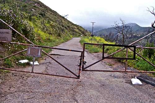 Walk around the locked gate

From US Highway 101 in Santa Barbara take the Mission Street off ramp and turn right at the light. Continue on Mission street passing in front of the mission building to a stop sign at the intersection with Foothill Road. Turn right onto Foothill Road and left onto Tunnel Road. You will come to a fork. Take the left fork and drive all the way to the end. You can park on the right hand side of the road within the white lines. Additional parking may be found before the end of the road. Please do not park in the side streets. They are all private roads.