
-
 1356 Hits
-
 0% Score
-
 0 Votes
|
|
Route |
|---|---|
|
|
38.38618°N / 112.51646°W |
|
|
Hiking |
|
|
Most of a day |
|
|
Class 3 |
|
|
Overview
If you're looking for an alternate route up Baldy Peak this is not a bad way. The forest road leading there does have multiple stream crossings so having a vehicle with high clearance and 4 wheel drive is highly recommended.
Getting There
From the town of Beaver take 600 N towards N Creek Rd. Make a left and follow the road until making a left at N 3100 E. Follow that road as it becomes FR591 and stay on this for about 5.5 miles according to google maps. Once again there are something like 8 stream crossings so it's probably not a good idea to do this if the water is flowing fast and deep. There should be an unofficial fork where the main road will cross the stream again with a sign indicating that it's a flash flood area and a burn scar. The other road will just kinda end. Park in this general area
Route Description
5.6 miles one way
5100 feet of elevation
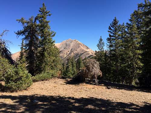
There is no trail for much of the hike, however I did find a good game trail once I was above the trees. The entire hike is on the ridge and as these things go there's much up and down. However one thing that will get you is that this is actually a twin summit and this route leads to the shorter summit on the west side. It's a short scramble to the true summit.
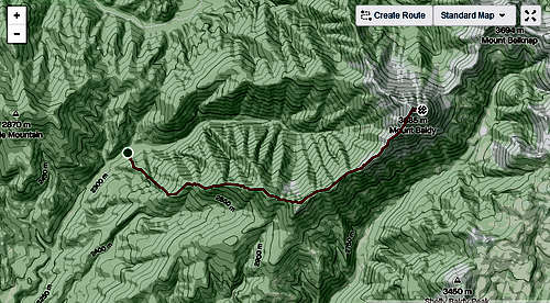
The most difficult part is the very beginning, it's something like 1300 feet up in the first mile and it's where the bushes are, well, bushier than the rest of the hike. Though they were all easy to bypass
Essential Gear
There's no water sources so bring plenty of water. I had trail runners and those worked well, bring boots if that's your preference.
External Links
Miscellaneous
I was tempted to go a different route back so I dropped into the main drainage to follow the old mining road back. This was a huge mistake as there was tons of avalanche debris, very steep hills to walk across, and eventually flash flood debris. The old road can be used for walking but it becomes a nightmare when it ends at a waterfall. Also it's something like a 2000 foot scree field to descend/ascend depending on which way you're going. On the other hand, if you felt like the ridge wasn't a good enough adventure for the day, dropping into the main drainage is a surefire way to quench that thirst