
|
|
Mountain/Rock |
|---|---|
|
|
37.75040°N / 105.5583°W |
|
|
Alamosa |
|
|
Hiking |
|
|
8617 ft / 2626 m |
|
|
Overview
Using the term "mountain" loosely, Star Dune a named, unranked summit in Alamosa County, Colorado, and resides within the Great Sand Dunes National Park and Preserve. Star Dune's elevation and precise location vary slightly with time as the wind continues to shape the dunefield. Latest measurements place Star Dune at an elevation of 8617', 1.40 miles due west of and with 277' of prominence to its parent summit, High Dune.
Most notably, Star Dune is identified by the National Park Service as the tallest dune in North America, measuring 750 feet (229m) from the valley floor to its summit. Despite being lower in overall elevation than High Dune, Star Dune earns the distinction of being the tallest dune in the park by earning an extra 100 feet of height as the valley floor slopes from east to west from High Dune.
There are other star shaped dunes in the park aside from this one. Created by complex wind patterns, star shaped dunes are radially symmetric with three or more arms radiating from the center of the mound. Star shaped dunes grow upward rather than laterally.
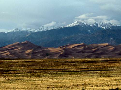 Part of the 30 square mile dunefield, Star Dune sits as the highpoint (left) in the sand in this photo as the Crestone Mountains gather behind
  |
 |
Getting There
Accessible from inside the Great Sand Dunes National Park and Preserve located in Alamosa County, Colorado, USA
Parking areas at the Visitor's Center and at the Dunes Parking Lot are good starting points for your trek to Star Dune.
There are no trails to the summit of Star Dune, so there a multitude of routes that you may take to it. From the Dunes Parking Lot, there are a couple of objective choices based on your goals for the day:
1] Star Dune via High Dune - Cross the parking lot and follow a sidewalk down to Medano Creek. Upon reaching the creek, cross to the other side. The highest visible dune immediately in front of you to the north is High Dune. Zig-zag your way up discontinuous ridgelines to its summit, approximately 1.15 miles from your starting point. From the summit of High Dune, look west and you will see the striking summit of Star Dune off in the distance, flanked by two smaller sub-summits.
The route you choose to reach its primary summit is yours, and depending on the efficiency of your route choices is approximately 1.40 miles away. Often, the most direct line is your best choice and you will ascend and descend several ridgelines along your way. The steepest portion of the climb will likely be the final ascent to the summit up the eastern side of Star Dune. This 30 degree slope can be an exhausting finish to your trek, but will soon be forgotten once you take in the views from the top. Return to the parking lot by reversing your route, or explore a new route on your own traversing due south of High Dune for an enjoyable loop hike.
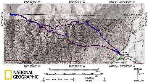
2] Star Dune only - Cross the parking lot and follow a sidewalk down to Medano Creek. Upon reaching the creek, cross to the other side and then follow it west until you reach the base of Star Dune's more prominent N-S ridgeline. Follow the discontinuous ridgelines of your choice to the summit. Depending on the efficiency of your route selection, the summit of Star Dune is approximately 3.8 miles from your starting point. Return to the parking lot reversing your route, or make the trek 1.40 miles east to the summit of High Dune for a nice loop hike.
 |
 |
Red Tape
Park Entrance Fee: $3 per adult (age 16+), valid for 7 days, children are free
Annual Pass: $15, valid for 1 year, applies to all family members in the vehicle with you
Pinion Flats Campground: $14 per night, restricted to 6 people and 2 tents per site
Medano Pass 4WD road: travel along this road requires high clearance and crosses Medano creek in 9 places. Airing down your tires to 25 psi is highly recommended. Car camping is available along the road at designated sites on a first-come, first-served basis
Backpacking: Backcountry permits are required, but are available for free at the Visitor's Center upon entering the park, during regular park hours
Visitor's Center Hours: (Winter: 9am-4:30pm, Spring: 9am-5pm, Summer: 9am-6pm, Fall: 9am-5pm)
Camping
Camping is allowed in the dunefield, outside of a specific day-use area defined by the park service.
Camping is also allowed elsewhere in the preserve, which includes the mountains surrounding the dunefield and is also part of the Sangre de Cristo Wilderness. Everyone who travels and/or camps there must abide by the regulations of the preserve and wilderness area. Permits for camping and backpacking are required if accessing the preserve from the main park entrance, but are free and available at the Visitor's Center upon your arrival to the park on a first-come, first-served basis. Designated car camping sites can be found at Pinion Flats Campground and along the Medano Pass 4WD road. Beware of hunters during the season as hunting is allowed in the preserve with a license.
External Links
Official National Parks Service website for Great Sand Dunes National Park and Preserve
Peak profile for Star Dune on Lists of John
Dunes on Wikipedia
SzaniUherkovich - Jun 21, 2009 10:19 am - Hasn't voted
Co-ordinatesHi HokieJim, I think that something may be wrong with the co-ordinates of this mountain. It's not in China, right?
HokieJim - Jun 22, 2009 2:05 pm - Hasn't voted
Re: Co-ordinatesRight, fixed, thanks!
SzaniUherkovich - Jun 22, 2009 3:15 pm - Hasn't voted
Re: Co-ordinatesWelcome!