
-
 6937 Hits
-
 84.27% Score
-
 18 Votes
|
|
Mountain/Rock |
|---|---|
|
|
37.87110°N / 111.11683°W |
|
|
Scrambling |
|
|
Spring, Summer, Fall, Winter |
|
|
7102 ft / 2165 m |
|
|

Overview
If you look at the Studhorse Peaks on a topographic map, you will probably not be seized with a desire to climb them, for they lack much vertical rise (about 500’ at most) and are completely shaded, indicating that they are tree-covered.
If you see them in person, you probably won’t get too excited, either, for the peaks do indeed not have that much rise and are indeed covered with many trees.
But do not write them off so quickly. Look more closely, and you will see that the tree cover (mostly junipers and pinons, which are not that high) is not as thick as maps would make you think, that there are many open areas on the summits, and that there are numerous opportunities for sandstone scrambling on the faces.
They also hold surprises. I climbed two of the peaks-- the one just north of the Burr Trail and the one just south of it-- and at the summit of the second one I “discovered” a short slot canyon, with walls about 40’ high and less than 6 feet apart in many places, that opened into a gully that in turn led to sandstone ledges that helped me make a nice circuit of the peak. And the scrambling on each peak I climbed was Class 3 and 4, with some interesting, though not terribly challenging, route-finding exercises on the northern peak.
So if you’re on the Burr Trail between Boulder and Capitol Reef National Park and are looking for a summit scramble, stop and visit the Studhorse Peaks, from which there are sweeping views that include the dramatic Waterpocket Fold and the Henry Mountains, one of the most remote ranges in the United States.
The peaks, all of which are at least 7000', run northeast to southwest, and as far as I can tell, there are five of them (though one has two summits with less than 100' of rise between them), with the highest being the middle one at 7140' (an estimate based on the contours). A map discrepancy makes me wonder, though; on the USGS Pioneer Mesa quad, the southwesternmost of the peaks is 7003', but on the Trails Illustrated map for Capitol Reef National Park, it is nearly 7200', which would make it the highest of the group. There is one way to find out for sure, though...
For the purposes of this page, "North Peak" is the one on the north side of the Burr Trail, and the others are, from NE to SW, "South Peak" 1, 2, 3, and 4. If these peaks have their own names, I would be happy to know about them.

Getting There
Two miles west of the Capitol Reef National Park boundary, or 31 miles east of Boulder (on UT 12), the paved section of the Burr Trail cuts between North Peak and South Peak 1. There is a large parking area just west of a cattle guard and a small one (room for one car, really just a pullout), just east of it. Parking at the second location does cut some distance and elevation gain from your climb(s).
Route Information
In my opinion, there is no need to put up separate route or mountain pages for the different peaks, and below I will include details about the two that I climbed. Should you climb one of the others and wish to add details about it, please let me know. And if you strongly feel that a separate page is warranted, then I will redesign this one and add pages myself so that everything works together well.
North Peak

Where the Burr Trail goes through the Studhorse Peaks, this peak is directly north/northeast, and it is easy to study its rocky faces from the road. Its location at the northern end of the peaks means there are excellent unrestricted views to the north from its summit, and those views extend well into the reefs and domes of Capitol Reef National Park.
I wouldn't call this peak challenging, but of the two I did climb, it was the more challenging. I knew that I could find easier terrain to the left as I face the peak, but I preferred the "problems" posed by a more direct approach. The climb was less than half a mile and involved only about 400' of elevation gain, but once I reached the rocks, it was pretty much sustained Class 3 and/or twisting through minor jumbles of rock to find the best way through. The "crux" was Class 4, but it was short and exposure wasn't too significant (remember that Class 4 and perception of exposure can be highly subjective). Up top, there were several ledges along the edges of the butte-like peak that offered excellent views out and dizzying views down.
Going down, I did angle west a bit to find Class 3 terrain.
South Peak 1

From the road, the distance to the summit is a little less than half a mile and entails a climb of about 400'. Most of the climb is Class 2, and route-finding is easy, but there is come Class 3 terrain near the top.
This peak has two summits, and there is less than 100' of rise between them; the higher summit is the eastern one, the one you reach first when approaching from the parking areas described on this page.
Unlike its neighbor across the road, this peak has a summit with more exposed rock than trees, and views are better.
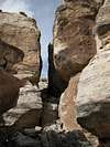
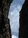
But the real treat on this little peak is the short slot located a short distance west of the highpoint. I imagine very few people know about this slot, and while it is far from deserving a place among the great slots of the Southwest, it is a nice "surprise" to find and enjoy up here.
The slot is only about a tenth of a mile long, and although it is not very high (maybe 40'), it is quite narrow in places (less than six feet wide, and sometimes narrow enough for a hiker to touch both walls at once). It is possible to scramble down to either of the two openings that access the slot and then hike through. At the other end, a short gully drops to a rocky area from which one can scramble down to reach fairly level terrain leading all the way back to the parking area.
The full circuit of this peak, going directly from the road to the summit and returning via the slot, is about a mile.
Thumbs of the slot, in sequence:
 |
 |
 |
 |
 |
 |
 |
Take Care of the Crust
As much as possible, avoid stepping on the biological crust out here; it is alive and is critical to the desert ecology, and it is fragile. If the soil looks lumpy, dark, or crusty, avoid it. Better yet, try to stay on exposed rock and in sandy washes as much as you can.
More about the crust...
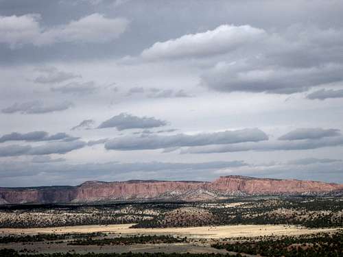
Some Views


Red Tape and Camping
No fees or permits. Obey posted signs about vehicular usage. President Bill Clinton's creation of Grand Staircase-Escalante was controversial, and some anti-wilderness people intentionally used ORVs to degrade the landscape in order to reduce areas qualified for wilderness designation. Please do not add to the scars of the past and the present, and give the recovering areas a chance.
There are no developed campgrounds near the Studhorse Peaks, but the BLM site indicates a suggestive primitive site nearby, though I do not recall seeing it. Most people probably car camp here, and if you do, please use preexisting sites and do not camp on the biological crust.
For more information about use and restrictions, visit the BLM site for Grand Staircase-Escalante National Monument.