![Route]() Route to Mt. Grant
Route to Mt. GrantThe Mt. Baker alternative
Dennis and I had planned to do Mt. Baker this weekend but the reports we were getting from the northwest were not promising for heading up there due to the weather. I had an alternative however and it was Mt. Grant in Nevada, a peak I needed to get to finish up the Nevada county highpoints. I had been lacking Mineral county since I had done Star Peak, my 16th county highpoint back in 2006.
The biggest problem with Mt. Grant is that it is on a military reservation
near Hawthorne Nevada and it might not be accessible. I knew that they no longer issued a key to the gate that allowed previous highpointers to drive most of the way up the mountain but Dennis and a few others had found a backdoor option, going in via the Monarch Mine in Lapon canyon. The downside to this is that it is a long drive on dirt roads to get to Lapon Canyon and then you have a good 14-18 miles of hiking (depending on your route) and close to 5000 feet of elevation gain to get the job done.
Fortunately for me, Dennis was willing to do it again (read his
trip report here) and this got me the green light from my wife who did not want me doing this one solo. She hates it when I do stuff solo anyway and considering the location and
isolation, she really was against me trying this one on my own.
A little history
In 2004, Dennis and I had made a run to do the remaining county highpoints of Nevada in October of that year. We had met near Cold Springs Nevada, Dennis driving down from Medford Oregon and myself driving down from Kennewick Washington. We proceeded to knock off the county highpoints of Churchill (Desatoya), Lander (Bunker Hill), Eureka (Diamond Peak), Elko (Ruby Dome),White Pine (Wheeler Peak), and Lincoln (Mt. Grafton) before I tore up my right knee coming down a talus slope on Mt. Grafton. I had to head home for treatment on my knee (torn medial mediscus) and Dennis went on to do Nye (Mt. Jefferson) and finally Mineral county (Mt. Grant) to complete all of Nevada, a notable accomplishment considering that he had done 8 counties in 8 days. The easiest of that group was probably Desatoya peak but my injury left me three county highpoints shy. I lacked Nye and Mineral as well as Pershing county (Star Peak).
I picked up Nye and Pershing counties by myself in 2006 but still
had Mineral staring me in the face. Since my wife had asked me not to
do it solo, I had to wait until the appropriate time and with a partner.
What better partner than someone who had already done it and knew the route. Dennis was the best possible partner I could have had for this plus he was willing to witness my completion of the state of Nevada.
Fast forward to 2008
Having decided against making a long trip to the northwest and dealing with the crappy weather they had been having, Dennis and I decided to hook up in California and do some prominence peaks there prior to heading for Mt. Grant. Driving across the state of Nevada on famed highway 50, I managed to time my arrival at our meeting place (Crystal Springs campground) west of Carson Passon highway 89 perfectly. I had barely found a spot and parked my truck when Dennis pulled in just 15 minutes later. He had managed to pick up a prominence peak (State Line) on his way down and had even spent the previous hour scouting our next objective, Hawkins Peak (10024). The next morning saw us up early as we went after both Hawkins Peak and Round Top. From Round Top we headed back into Gardernerville and headed south to position ourselves for Patterson Peak (11673) the next day. We car camped at Lobell Lake and picked off Patterson before heading into Bridgeport for lunch.
![South face of Hawkins Peak]() Hawkins Peak
Hawkins Peak
After studying the maps we had, our next objective was Bald Peak (9544), a
prominence peak close to Mt. Grant on the Nevada side of the border
from California. We found the roads we needed and after driving in 7 miles
on rough roads, hiked the last several miles to the summit of Bald. Now the goal was to get to Lapon canyon and position ourselves for Mt. Grant.
![View south toward the cirque...]() Mt. Patterson
Mt. PattersonLapon Canyon
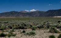
![Mt. Grant & Lapon Cyn]() Lapon Cyn from the main dirt road
Lapon Cyn from the main dirt road
Heading south on Nevada 338 12 miles (from Nye Canyon road for Bald), we
turned east on a dirt road, referred to on the Benchmark map as FS 038 and as the Sweetwater road. This well graded dirt road allowed us to intersect with a road that turned north, just a couple miles east of the 9 mile ranch (the road goes right through the ranch home area and a rustic sign notes that it is 25 miles to Hawthorne as you cross a stream). The road that turned north is noted as the Aldrich Grade on the Benchmark map and Dennis led the way unerringly to the turn off to Lapon canyon (maybe ten to twelve miles). No sign marks the turnoff and the road is fairly rough but since I was following Dennis, I didn't keep mileage records although I did take one pic that might help. Following the ever roughening road, we found our selves at the mouth of the canyon and a spot where Dennis had been stopped three years before. The road had been improved enough since then that we were able to drive further on up the road but made the mistake of trying to go much further than just a half mile or so.
![Road is going back]() Nature is reclaiming the road
Nature is reclaiming the road
If you check out the captions on my pics, you will understand that you are looking for a spot around the 7000 foot mark. You can go further but your paint job will pay the price and you will be stopped by large rocks at the 7200 foot level. Not worth it. A great spot to park and camp can be found
on the north side of the road (see pic of trucks). We made the mistake of going up to the 7200 foot level and had to back down a ways and turn around, subjecting our vehicles to the paint scratching gauntlet that we had to run for the second time.
After parking and getting our packs ready, we settled in for the night, planning on a 5 a.m. time to get up for our Mt. Grant hike the next morning.
The hike
By 5:30 a.m. we were on the road up the canyon and noted that the road had really disintegrated beyond where we had been stopped by the big rocks. By the time we got to the Monarch Mine at 7900 feet, we knew that the road was
never going to be useable again by vehicles and would continue to deteriorate. Perhaps it will become a moot point
when the Army Depot opens up the road on the east side again and you can approach from the Hawthorne side (which most likely will eventually happen).
![Old mine opening]() Halfway up the switchbacks
Halfway up the switchbacks
Noticing the junk that was all over the place, we started up the switchbacks above the mine. The road switchbacks up another thousand feet where it suddenly ends leaving but a short cross country hike up to the ridgeline where we found an old farm road. We gps'd both the end of the road and the ridgeline access so we could find the exact spots on our way back. I also put up some pink surveyor ribbons as a guide and retrieved those on the return. I like to use them as it makes route finding very simple.
![What gate?]() What gate?
What gate?
Once we hit the road, we walked on it south for a bit until we encountered the fence line and a little further on where the gate would've been. Would've been? There was no gate standing as it appeared that someone must have run it over. No warnings, no gate. How much easier could it have been? We continued on our way, dropping down hill and around the hill in front of us as we made our way to the 5 way intersection. Dennis had already done the road in its entirety the first time he did the mountain so this time, he had figured out that we'd save some good miles and time if we
strategically went cross country between switchbacks, making certain to take the road that led to where we wanted to go when we got to that road.
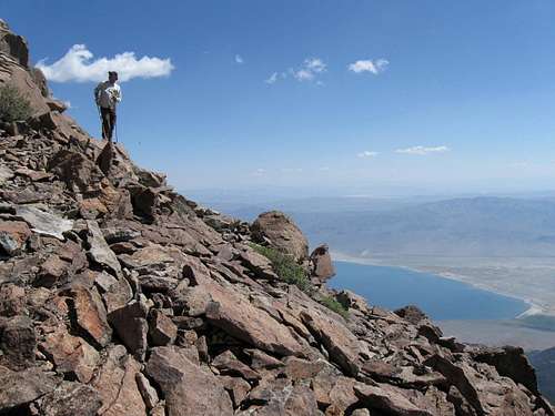
![Near the top]() Near the top
Near the top
As you can see in the pic of the sign, if you take the road all the way, it is 6.5 miles to Mt. Grant. However, if you cut the switchbacks as we did, you can knock off 2.0 miles each way, reducing the road hike to a mere 9 miles round trip from the 5 way junction. Add an additional 5.5 to get to this point (round trip of course) and you can see the overall hike is between 14-15 miles, not 18-19 miles.
When we got through going cross country (very easy), we just followed the road until we hit a drainage at 10,200 feet. We went up the drainage and thus cut the switchbacks again. Finally, we got to the parking area at the base of the summit area and the summit itself is composed of a huge pile of rocks, over 150 feet high. Leaving our daypacks at the parking area, we made our way up the rockpile, taking the best route we could find. There is no need to describe this portion of the hike, it is pretty obvious as far as which way to go.
Within a few minutes, we were on top of Mt. Grant and I was celebrating my
final county highpoint achievement. It was great to have Dennis there to give me a high five and congratulations. A special moment indeed with a special friend.
It had taken us 5 hours to get to the top and our return to our vehicles,
uneventful, took 3 hours so we put in our "eight" hour day at the office.
The best way to put in an eight hour day IMHO. ; )
Many thanks to Dennis for being my "tour guide" and partner on this mountain and for the company of the whole weekend trip. Dennis went on to do Glass Mountain near Benton and I headed for home, spending the night in
Tonopah on the way.
Nevada County Highpoints
See
this page for more information.
Maps
I have put together two maps. A couple of key items.
From Hawthorne, go over Lucky Boy Pass (23 miles from Hawthorne to
key junction. Head north on state route 3C about 11 or 12 miles to get
to turn off for Lapon Canyon. I suggest you use GPS to mark the road
junction as it isn't signed and it would be easy to miss, particularly in the dark. See pic posted above that shows Lapon Canyon from the main road (dirt)and you'll see a small whitish spot which isn't snow but is a landmark for the opening of the canyon. The Lapon canyon road is a bit more than 4 miles from the main dirt road that you come up on from the before mentioned
junction.
Wildlife
I always keep my eyes open in this desert country for rattlesnakes but generally what you do see is harmless ones like the one below. Other wildlife on the Mt. Grant area seem to be deer and possibly elk & proghorn antelope.
[img:416213:alignleft:medium:]


Comments
Post a Comment