
|
|
Mountain/Rock |
|---|---|
|
|
34.87200°N / 83.075°W |
|
|
1780 ft / 543 m |
|
|
Overview
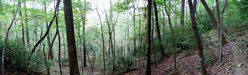
Cove hardwood forests.
Tamassee Knob (pronouced TAM-ass-ee, as in Tennessee) is a relatively low but impressive peak just at the edge of the Blue Ridge escarpment in the northwest corner of South Carolina. While not terribly high, even by the very modest standards of South Carolina peaks, Tamassee Knob rises abruptly from the Piedmont as a prominent point on a plateau that bleeds down between higher terrain and the hills that lead down to the coastal plains.
I wanted to hike this little mountain not because of its prominence, but because I had been told that its slopes were covered in a beautiful second-growth and old growth hardwood forest. How these acres came to be spared the bite of the woodsman's saw I cannot guess, save for the tortured terrain that afforded them protection when easier timber was to be had. I had also been told that the steep slopes and sheltered coves of Tamassee Knob held some very large champion and near-champion caliber trees of many different species.
When I scanned the land approaching Tamassee Knob, I had my doubts. There are lots of scrub oak and young pines, but nothing impressive as one gets close to the trailhead. Indeed, you have to hike through a sickly stand of very young pines to get to the slopes, and things did not look good. However, after about a half-mile of hiking one does indeed enter an extremely grand example of a classic southern cove hardwood forest ecosystem. The slopes of the Knob are extremely tough to negotiate and I can see why any lumber company thought twice about tackling them again (I feel certain the place must have been logged, but no more recently than 200-250 years go). The place begs for some Fall and Winter bushwhacking, when negotiating those improbable slopes would be far easier.
There are some grand views from just below the summit, and from several points along the trail as it traverses the narrow ridges. But the main draw of Tamassee Knob are the great hardwood forests that clothe its slopes and help to make its coves places of truly great beauty.
 |  |
Getting There
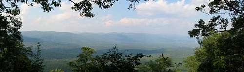
Summit view.
From Walhalla, drive northwest on SC 28 for 7.5 miles and bear right on SC 107. Continue on 107 and take the entrance to Oconee State Park. After the fee station, turn right and drive to a small parking area (only large enough for four or five vehicles). There, follow the sign for The Foothills Trailhead.
The Tamassee Knob Trail begins at only about 100 feet lower than the summit. But you have to drop into a number of low gaps along the way and regain it on the ridges leading up to the summit. So the 4.2 mile round trip is a bit tougher than one would expect. If hiking this peak in warm weather, be sure to take plenty of water.
Also, as another summitpost member warns, this area is bad for ticks in the summer! Take all precautions against tick bites! Rocky Mountain Spotted Fever and Lymes Disease are not worth the risk!
 |  |
Red Tape
There is an entrance fee of $4.00 to enter the park and use the trails, unless you are staying at a cabin or the campground. If staying in the park, the trail fee is included in your campground/cabin charges. |
When To Climb
All year. It gets very hot and muggy here in the summer, and ticks and chiggers can be a big concern. Winters at this location are very mild and only rarely does one encounter snow and icing conditions. |
Camping
There is a vast developed campground inside Oconee State Park. Fees for full hookup sites are $21.00 per night. Tent sites are less. Phone the park at 864-638-5353 for current fees.There is ample backcountry camping available all along the nearby Foothills Trail.
 |
Mountain Conditions
Check the weather for Walhall, South Carolina. |
External Links
- Tamassee Knob Trail.
Official State of SC trail description for Tamassee Knob Trail.
- Oconee State Park.
Official site for Oconee State Park, where Tamassee Knob is located.
gwave47 - Jul 26, 2006 3:54 am - Voted 10/10
Route leaves State ParkHello Bob! You always do a great job on your pages and i'm glad that you are responsible for a good majority of the moutains in the Southeast since these are the ones I climb the most. Your information is always very precise and correct, I have encountered few unexpected twists when hiking the mountains that you control the SP page to. On this particular mountain however I thought it may be important to notify hikers of this route that the trail does leave the State Park. The significance of this is to inform people that once you leave the state park the remaining mile or so of the trail is not as clear cut, there is overgrowth which can occassionally make the traiil a bit more difficult to follow. Also, ticks thrive in this overgrowth during the summer, so its very important to wear long pants during the summer because once you leave the park side of the trail you will find your legs covered in ticks. Thanks Bob, keep up the good work!
BobSmith - Jul 26, 2006 5:50 pm - Hasn't voted
Thanks!That's good advice! My nephew, who lives in Greenville SC is now recovering from Rocky Mountain Spotted Fever. His doctor told him that if he'd been older, he'd have died. When he got to the doctor's office, his temperature was 106! He'll be weeks recovering. Yep, that part of the Apps is loaded with ticks in summer! I wasn't aware the trail left the park! It was marked and blazed along the whole distance I hiked.