
-
 7732 Hits
-
 86.85% Score
-
 23 Votes
|
|
Route |
|---|---|
|
|
50.59234°N / 16.12577°E |
|
|
Hiking |
|
|
Spring, Summer, Fall |
|
|
Half a day |
|
|
Easy hike |
|
|
Overview
 Teplicke skaly sandstone
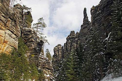
Teplice-Adrspach Rock Town is one of the most spectacular Middle Europe sandstone areas. Here I am describing only one of the usual tourist hikes - perhaps the most beautiful one - through the Teplice Rock Town (In Czech: Teplické skály - Teplické skalní město). This is the tourist hike and the trail is also equipped with educational plates. More about the broader are and about other outdoor possibilities you can find on the parent page. The Teplice Rock Town hike enters the area by a nice valley, which forks on a stunning place, just below the tower called Skalní nevěsta (Stony bride). So, the upper part of the hike is a spectacular round tour. You eventually take the south gorge, cross from its higher part into the south-west gorge and return to the junction. This circular path is not allowed in spring, when the area around the so-called Temple walls is closed for all visits. There the endangered duckhawk is nesting and shouldn't be disturbed in that part of a season.
Basic Information
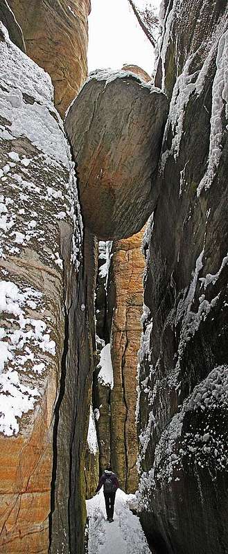 In Siberia canyon
Difficulty. It's an easy hike (on the Swiss Hiking Scale its difficulty would be graded T2. Also the ascent on Střmen Castle, which is a bit more demanding, is nothing but a steep ladder. You need for it only a bit of additional breath and absence of vertigo - but let's grade it then T3.
Objective dangers. I don't really see any. Of course in a sandstone canyon you intuitively always feel that something can fall on your head.
Orientation. Tre trail is well marked (blue marks). As there are also other hiking combinations, you either stay on the main trail or get a decent map of the area (the official one is: Adršpašské skály Teplické skály, 1:16.000.
Best season. Due to their popularity the canyons can be visited virtually through the whole year - except perhaps hard winter is not the season to be recommended. In spring you will still find snow on the paths, but so many visitors trample it well. In summer and autumn you will eventually find crowds on the path - a good reason to avoid the most busy times.
Gear. In summer conditions also sport shoes will do. In April 2015 we had some 25 cm of snow in the canyons and we had some issues, wearing only sport shoes. Good hiking shoes and poles would be an optimal combination, because parts of the trail were realy icy. If you extend the described tour, you will find other trails less beaten. In winter conditions they may become more dangerous.
Tour start. Just west of Teplice nad Metují there is a big parking lot near Hotel Orlik, cca 490 m. See the parent page how to get there.
Fees (2015). Parking: 50 Kč (less than €2). Entrance fee: 70 Kč (€2,6).
Highest point. Some 675 m.
Time for the tour: The whole hike is some 6-7 km long and requires with sightseeing close to 3 hours. I bet you'll not hurry on this hike!
Route Description
From the entry you go westwards by the forrested valley of the Skalní potok (Rocky creek). You always follow the blue trail (most beaten). Soon towards the right the yellow trail deters (it goes northwards, by Vlčí rokle - Wolf gorge - it reaches the second big rocky area, Adršpach Rocks). We continue in the same direction and the path soon turns a bit left, into the valley of right tributary creek of Skalní potok. After some 20 min from the entry, we are below Střmen Castle. From the broad main trail toward the right steep stairway goes up. After some 60 m of ascent you are on the ridge and to the right there is the last, steepest ladder. The lookout point on the highest rock is certainly worth visiting. Otherwise there is nothing left of the ancient 13th century guard castle, as already in Hussite Wars, or later in 1447 it was completely destroyed. You descend on the main trail by the same route.
 Střmen Castle Střmen Castle |
 The last ladder The last ladder |
 Panorama Panorama |
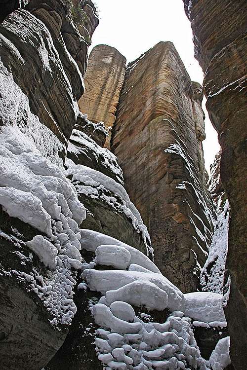
Continuing deeper into the valley, the scenery becomes more and more picturesque. On both sides of the valley bizarre rock towers appear. The plates are offering their names and you don't need much imagination to see those objects in them. Soon you pass the Rock Gate with the inscription plate, mentioning the visit of this area by Johann Wolfgang Goethe (in 1790). Then you continue by the valley and soon reach the branching of it. There is the new hut U skalní nevěsty (At the Rock Bride). You are now in the centre of the Rock Town.
 The rock gates The rock gates |
 Scenery Scenery |
 The horse head The horse head |
If we continue the last part in the clockwise direction, we go a bit left, through a narrow canyon into the Velké chrámové náměstí (Great temple square), a beautiful, small valley, surrounded by sheer rock towers. At the upper end of it there is a narrow passage with a stone chapel and on the other side another nice valley: Malé chrámové náměstí. (Small temple square). In the narrows which follow, there are stone gates and in spring there the passage is closed.
 Rock guard Rock guard |
 Great Temple Square Great Temple Square |
 Small Temple Square Small Temple Square |
If you are able to continue, the canyon soon broadens and around nice meadows there are the highest walls. This is another very popular climbing area. Continuing, the path goes around the rocks, and also ascends a bit more, keeping to the right. After passing the second stone gate, the paths starts descending. You are now in the valley, which will join the junction at the Rock Bride from the south west. Passing some interesting towers you are soon on another crossroads, in the Anenské valley. Here the green path deters westwards. But we need to close the loop, so we continue downstream, into the beautiful, narrow canyon of Siberia.
 Anenské valley Anenské valley |
 In Siberia canyon In Siberia canyon |
The broad, very picturesque Anenské valley soon squeezes the path and the passage into the gorge is only a good meter or two wide. Along the path there is only a place for water stream and in one place we even go below a big boulder, jammed between the sheer walls. The place is cold and shady, hardly any direct sunlight enters the canyon and some 200 meters we are winding through such a nice scenery. Then we exit on the already well known place - by the hut U skalní nevěsty. From there we return to the parking place by the approach path.
Route Extension
 Another Sphynx
As start of April we could not do the whole upper loop, we went by the south canyon to the barrier, then back to the junction and through Siberia canyon to the crossroads in the Anenské valley. There we continued westwards by the green path. It goes much around, but on the next crossroads you spot another blue path, deterring right. Soon it gets the right direction - towards the north. You ascend some 50 meters and then a long descent awaits you. Finally you reach the yellow path, deter right and continue towards the parking place.
External Links
More about the history of Adrspach-Teplice Rocks, fauna, flora and other tourist information you can find on the following web pages (in English): Hiking trail - some other details: http://www.teplickeskaly.com/teplice-rocks/rock-town/hiking-trail/ Adršpach-Teplice rocks: http://www.skaly-adrspach.cz/en/