
-
 15776 Hits
-
 92.32% Score
-
 38 Votes
|
|
Canyon |
|---|---|
|
|
44.72283°N / 110.47654°W |
|
|
Hiking |
|
|
Spring, Summer, Fall, Winter |
|
|

Overview
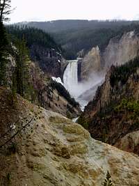
Starting at the brink of the Upper Falls, the Yellowstone River cuts through this gorgeous canyon filled with vibrant colors, steep walls, and majestic cascades for about 20 miles to the Tower Falls area. Stretching from 1,500 to 4,000 feet wide in areas and dropping as far as 1,200 feet deep, this canyon earns its “Grand” stature with all the beauty it holds inside. Looking downstream from the shaking brink of the Lower Falls, one could swear he or she is looking at an enormous painted mural. The streaking hues along the canyon walls are surreal. The waterfalls falling from its rims and center are mesmerizing. There’s no question why the Grand Canyon of the Yellowstone has been captured through some of the park’s most memorable photographs.Getting There
There are plenty of ways to explore the Grand Canyon of the Yellowstone. First and foremost you have to make your way into Yellowstone National Park in the North West corner of Wyoming. Once there make your way around the grand loop following obvious signs or your handy brochure given to you by the rangers at any entrance to the Canyon area. The canyon offers several hiking trails ranging from easy to strenuous. But if you aren’t much for adventure or exercise you can still see some of the best the canyon has to offer from the comfort of pavement and railings. From the Canyon junction you can take the roads leading to Inspiration Point, which is nothing short of inspirational. Back track from here to the one way road leading to Grand View and Lookout Point, and then eventually dumping you back on the grand loop road about a mile south of the canyon junction where you started. Take a left onto the grand loop for another half mile to the two way road on your left leading to the brink of the Upper Falls. A half mile past this road, further south on the grand loop, you will find a large sign on the left, pointing you in the direction to Artist Point. I recommend getting an early start to your day to do this roadside tour of the canyon to avoid the crowds, especially in the summer months. After getting your fill from behind all the signs and railings, spend the rest of your time hiking the trails around the rims and into the canyon.

Hiking Trails
South RimThe south rim trail stretches 3.2 miles from the Chittenden Bridge, just upstream of the Upper Falls, to Point Sublime. This trail can be done as shuttle from Artist Point to the Wapiti Lake trailhead or an out and back from any section of the trail to another. Views include those of the Upper Falls from its namesake overlook, the Lower Falls from Artist Point and other various spots, and an expansive view of the canyon from Point Sublime.
 Artist Point
Ribbon Lake
This trail is best started from the Artist Point parking area. From here, head for Point Sublime on the rim trail, hiking right along the canyon’s edge. After half mile turn right onto the Ribbon Lake trail before reaching Point Sublime. Turn left at the next junction with the Clear Lake trail less than a half mile from the rim trail. The next mile will be mostly in the trees until reaching Ribbon Lake. Follow a trail around the western side of the lake to the Silver Cord Cascade Overlook, where you will suddenly be standing on the canyon’s edge again, peering down the 1,200 foot drop to the Yellowstone River.
 Upper Falls
 Uncle Tom's Ladder
Uncle Tom's Trail
This is a trail unique from most, because it really isn’t a trail, but a series of steep stairs. Climb down the 328 steel mesh steps from the south rim to a viewing area very close to the base of the powerful Lower Falls. This is a short distance to hike, but climbing back up the staircase can be strenuous.
 Crystal Falls
North Rim
The views from the North Rim trail rival those from the south rim. And like the south rim, the North Rim trail can be done as a shuttle, from the Chittenden Bridge to Inspiration Point (3 miles) or hiked in desired sections. From the bridge it’s a short ¼ mile to the Brink of the Upper Falls. Here the Yellowstone River plunges 109 feet and marks the start of the Grand Canyon of the Yellowstone. Crystal Falls on Cascade Creek is reached just before your first mile of hiking. The trail actually crosses right over top of the falls. Shortly after crossing Cascade Creek, you’ll pass the side trail leading to the Brink of the Lower Falls. Half mile past this junction is the short side trail to Lookout Point. And just past here is the side trail down to Red Rock Point. Both side trails give amazing views of the canyon and its Lower Falls, but the Lookout Point trail is a 50 foot stroll, while the Red Rock Point trail is a steep quarter-mile drop. Finally the paved trail dwindles to a normal dirt and rock hiking path once you get to Grand View Point, which offers more memorable views of the Lower Falls. From here the trail stretches another 1.5 miles to Inspiration Point and its inspiring views with a very broad glimpse of the Grand Canyon before it.
Brink of the Lower Falls
The easiest and shortest way to get to the brink of the Lower Falls is by starting onto the north rim trail from a large parking area just before the one-way North Rim Drive rejoins the Grand Loop. It’s only a 1.5 mile roundtrip hike, but offers one of the most breath-taking views in the entire canyon. Standing on the cement platform, looking over the railing, the waters of the Yellowstone River seem to be within your reach just as it drops 308 feet. Looking downstream, canyon walls look more like soft paintbrush strokes of pink, yellow, gold, red, brown and every hue in between. And if you are there at the right time of day the sun streaks through the mist of the falls below creating an amazing waterfall in your foreground shot of the canyon.
 Brink of Lower Falls
Sevenmile Hole
Find the Glacier Boulder trailhead on the road leading to Inspiration Point. It will be on the right. The trail begins away from the canyon rim in a lodgepole forest. With the exception of a few glimpses through the trees, the canyon itself is not visible for the first mile until you reach the Silver Cord Cascade viewing area on the south side of the canyon. Another mile down trail you will reach the Mount Washburn trail junction. Take a right here, and after another half mile the trail starts its plunge over the rim with a series of switchbacks. The 2.5 miles from the rim to Yellowstone River passes a geyser and a small thermal area. The distance from the trailhead to the Yellowstone is 5 miles, but I guess can feel like 7 when hiking back out. The Sevenmile Hole actually refers to the distance downstream from the Lower Falls.
 Tower Falls
Tower Falls
This hike is the only other way by trail down into the canyon bottom, which at this point, marks the end of the Grand Canyon of the Yellowstone, and is a must do. It’s only about a mile in length from the overlook of Tower Falls in the Tower area (about 18 miles north from Canyon Junction on the Grand Loop). The trail was meant for the viewing of Tower Falls, a 132 foot waterfall dropping from rocky spires at its brink. After taking in the falls follow Tower creek downstream until it disappears into the Yellowstone River and the end of its Grand Canyon.
Red Tape
There is a $25 entry fee into any of Yellowstone National Park's entrances. This covers you for a week in both Yellowstone and Grand Teton National Parks.Backcountry permits are required for any overnight stay in the backcountry. A $15 fee is required if reserving a backcountry site, otherwise you can obtain a permit at no cost on a walk-in basis. Walk-in permits can only be issued 48 hours or less prior to the hike and are obviously based on availibity.
 Just below the bridge the Grand Canyon opens under the Upper Falls
Camping
There is a large campground for the casual drive-in campsites within the Canyon Village. Be sure to make reservations early here.There are numerous backcountry sites around and within the canyon region. Backcountry campsites require a permit. Make sure you get one. Campsites at Sevenmile Hole and Ribbon Lake are noted as being some of the park's most picturesque.