Introduction
![Asomate de Hoyos]() Asomate de los Hoyos on Cuerda Larga Asomate de los Hoyos on Cuerda Larga |
Three years ago we visited central Spain for the first time. An ex-colleague of Judith’s, who is married to a lady from Madrid, had suggested
Sierra de Gredos. We had a wonderful time – even though the highest mountains around
Circo de Gredos were off-limits due to a massive pack of snow which only slowly melted. During the trip from
Madrid to
El Barco de Avila, were we stayed, we had to cross
Sierra de Guadarrama through the motorway tunnel and this mountain range – even closer to
Madrid - suggested itself for future endeavors.
Then, at the start of 2017 a new hiking guidebook was released for
Sierra de Guadarrama and having had nothing but good experiences with its twin about
Sierra de Gredos (same edition, different author) we decided to road-test it later in the year. We decided on June – those snow packs of 2013 still ranked in our minds – and found a nice large apartment in
Moralzarzal, just south of the range with most possible destinations less than 50 km away.
Even though it happened to be my own suggestion, I remained lukewarm all the way up to the trip itself. The tours in the guidebook seemed ok – not too easy, sometimes a bit of a scramble in between – but they seemed to overlap quite heavily. Using the wikiloc.com site I grabbed hold of several dozen gps tracks but the impression stayed the same – lots of tracks but often sharing substantial distances with others.
Moreover, I didn’t really grasp the geography of
Sierra de Guadarrama. The guidebook claimed that there were three sections, north, east and west but then there were hikes far in the south and a whole subrange,
La Mujer Muerta, didn’t fit into this picture at all. In the end – it took us the best part of a week to understand the range by taking a hike in all its different parts each.
June 3rd 2017 – Travel Day
The flight was scheduled to take off around 10 a.m. so we had an surprising amount of time for breakfast and general preparation. However, when we arrived at
Frankfurt airport the queues were incredibly long. Yet, all counters were manned so we moved quite quickly through the ranks to drop our baggage. Having checked in the day before everything seemed to be be fine. But then the clerk said – I doubt you’ll get the plane – the passenger checks are heavy today and boarding starts in 15 minutes. We ran to the checking zone only to find it half empty. We zoomed through it – and even though I had to open my rucksack we were at the gate way before boarding started. There was time for drinks and snacks and then we were on our way.
The remainder of the trip was without events. The flight was cool – actually they served food which has become rare – our baggage was the first to appear on the belts – there were no queues at the car rental booth – only we got a little lost on the parking lot trying to track down the car. Which turned out to be a fully equipped Astra, GPS and a host of electronic assistants and as the price had been quite low there was no way we would complain. Within an hour we were in the apartment unpacking stuff, taking a break and wondering what to buy for dinner in the supermarket right across the street. A good start to the vacation for a change.
June 4th 2017 – A Mixed Weather Forecast
Sierra de Guadarrama seen from Cabeza Mediana |
During the night it had rained and even though the weather seemed perfect upon inspection during breakfast, the weather forecast called for heavy thunderstorms later in the day, starting around noon. Therefore we decided not to head for the higher mountains but stay close to
Moralzarzal instead. A leaflet we had found in the apartment had suggested an 11km hike onto
Cabeza Mediana and
Monte Redondo just to the west of the town. At less than 1400m both mountains would certainly be not spectacular but we could get quickly off them and return to our vacation home.
![Southern Sierra de Guadarrama]() Southern Guadarrama Southern Guadarrama | ![Heavy Weather above Cabeza Mediana]() Cabeza Mediana Cabeza Mediana | ![Humming Bird Moth]() Macroglossum stellatarum Macroglossum stellatarum |
As it turned out, this day was a sign of things to come. It was hot, we had fine views towards the southern part of
Sierra de Guadarrama, a black vulture soared above us and big butterflies were flitting around the many flowers beside the trail. The summits of central
Sierra de Guadarrama were hidden in clouds, which started to pile up way before noon already. On
Monte Redondo, where we had an early lunch the weather was still fine, but shortly afterwards the blue patches started to disappear from the sky. We quickly descended and when we entered
Moralzarzal a black cloud was looming above
Cabeza Mediana. We just made it home before a torrential downpour washed everything away.
June 5th 2017 – La Pedriza de Manzanares, Part 1
Cuerda de los Porrones, Cuerda Larga, La Pedriza |
This time the weather promised to be better – the forecast called for a long spell of high pressure above
Sierra de Guadarrama. Due to the downpours the day before we anticipated thick clouds above the summits, however, so that we searched for a lower destination. Which was easily found in
La Pedriza, a maze of granite rock formations, which looked very promising in the guidebook. We decided on a loop trail in the south of
La Pedriza, actually around the whole of
La Pedriza Anterior, which could easily be extended. There were many hiking paths and the guidebook offered quite a number. Maybe it wasn’t too bad after all that hikes overlapped?
![Granite dome]() Granite domes wherever you look
Granite domes wherever you look
From
Moralzarzal it took 10 minutes to
Manzanares where we got ourselves lost. But 20 minutes later we were at the trailhead at
Canto Cochino. We had to cross a valley and then headed up towards the first rocks. We enjoyed the backwards views across
La Pedriza and
Cuerda Larga, the eastern branch of
Sierra de Guadarrama and soon entered a domeland like region of granite rocks. To the right a large griffon vulture perched on a rock – not the last one we would see today.
![Griffon Vulture]() Griffon Vulture Griffon Vulture | ![Sphinx-like face looking towards Madrid]() A Sphinx A Sphinx | ![El Elefantillo]() El Elefantillo El Elefantillo |
Our first destination was the little elephant,
El Elefantillo, but before we could reach it we had to bushwhack through a narrow valley. A Sphinx-like rock looked over the plains towards the capital
Madrid and suddenly a herd of female ibex scampered down from a rock beside it. Shortly afterwards we reached
El Elefantillo and did a set of the usual hero shots.
![El Acebo]() El Acebo El Acebo | ![Rock formations in La Pedriza]() Rock formations Rock formations | ![Pedriza Posterior]() Pedriza Posterior Pedriza Posterior |
On we went through domeland, the rock formations getting more and more bizarre. The hiking path turned into scrambles up and down chutes but the beauty of it all rewarded us for our efforts. After some named formations (
El Acebo,
Las Cuatro Damas) we had lunch before descending into
Collado de Dehesilla which separates
Pedriza Anterior from
Pedriza Posterior. And here another flock of ibex ladies surprised us (rather were surprised to find us there) and gave me a chance for a number of nice close-up shots.
![Welcome to domeland]() Domeland Domeland | ![Female Gredos Ibex]() Female ibex Female ibex | ![Ibex country]() Ibex country Ibex country |
Once in
Collado de Dehesilla we realized it would be too early to descend back to our car so one of these extensions of overlapping trails was called for. Judith had spotted a possible loop on our map which would take us hallway inside
Pedriza Posterior and then via a narrow track (so we hoped) back down into the valley of
Rio Manzanares. All we would have to do was to climb up and down.
![La Pedriza Posterior]() La Pedriza Posterior
La Pedriza Posterior
And up we went – steeply up – extremely steep in fact. The track switched back and forth through a maze of rocks and trees, rarely offering views around. The rocks got higher, the space between ever narrower. We finally reached a level spot in a saddle but immediately had to descend again and up and down it remained for quite some time. However, the formations now looked real great. I felt reminded of the
Calenche de Piana in
Corsica or the
Torqual de Antequera in
Andalusia – probably a mix of both.
![La Pedriza]() famous towers famous towers | ![La Bola de Navajuelos]() La Bola de Navajuelos La Bola de Navajuelos | ![User Profile Image]() Pedriza hiking Pedriza hiking |
After a particularly beautiful section the track vanished in a cave, a 10m low and narrow tunnel through one of the formations. We had to crawl and there was not much space left above us. Once beyond our jaws dropped. Here we were in a labyrinth of rocks with only the trail markers to guide us through. It’s tough to describe – one has to see it oneself. Pictures can only give a poor two dimensional rendition of reality in this case.
![A maze of rock]() A maze of rock A maze of rock | ![Look if you can see the vultures circling]() Domelike tower Domelike tower | ![El Tolmo]() El Tolmo El Tolmo |
We reached an intersection, where Judith’s descending trail turned off. So we did, following the trail for some 500m until – it vanished. Without the guidance of the GPS tracks I had downloaded we would have been lost. Actually we already discussed returning via
Collado de Dehesilla when we saw what looked like a cairn. And a second one just behind indicated we were on the right track. Now a nightmarish rock hopping scramble down a creek bed followed, ever so often seemingly ending in a high but dry waterfall. However, we always found an option to further descend, finally reaching the huge monolith
El Tolmo, where we finally took a break. Later we descended into the valley and back on the
Autopista track (named for the hiking traffic, which was low today) towards our car in
Canto Cochino.
June 6th – Guadarrama South
Originally we intended to drive to
Puerto de Guadarrama to see whether weather would allow us hiking north or south. But when we caught a glimpse of the pass we realized we had to go elsewhere. Thick clouds were cascading across the saddle and it seemed impossible to predict when the good weather would arrive there. So Judith grabbed guidebook and map and directed us towards
San Lorenzo de el Escorial, where we could start the intended southern route from the other side. Here weather looked much better and chances for an interesting outing were far bigger.
Summit panorama from Abantos |
We skipped
El Escorial, the large palace / monastery built by Phillip II, and drove as highly upwards as we could, parking our car to the side of the road. A generally rather boring forest ascent led to a lower ridge, where we got our first view of the neighboring summits. A short traverse took us to our first summit,
Abantos (1753), a good lookout across the
Madrid Plain, the northern part of
Sierra de Guadarrama and
Sierra de Gredos to the south-west. Also you get a perfect aerial view of
El Escorial from its top.
![Refugio La Naranjera]() Refugio La Naranjera Refugio La Naranjera | ![Sierra de Guadarrama above Embalse de la Jarosa]() Cuerda Larga Cuerda Larga | ![Valle de los Caidos]() Los Caidos Los Caidos |
The second of our summits,
Cerro San Juan, turned out to be little more than a broad bump on the even broader ridge, marked only by a fence which turned directions right at the summit. Not much to relate from it even though upon returning we had some good Guadarrama views. In the morning, however, we passed by and more or less quickly descended to
Refugio la Narajera, a ruined building, built in one of the lower saddles on the ridge. Its surroundings are rather impressive with a multitude of granite rocks piling up around.
360 Summit panorama from Cerro de Carrasqueta |
After that we descended further – away from the ridge – only to find we had lost the route. With the help of GPS maps we found a narrow path leading back and then along the ridge until we reached the base of
Cerro Carrasqueta (1640m). As it was lunchtime we decided to hike up to the summit and spent a windy half hour hidden in a nook on the off-wind side. But for the clouds still hovering about the 2000ers of
Sierra de Guadarrama we had wonderfully clear views. Up close, a bit the south-east of the summit we saw Franco’s monument
Valle de los Caidos – another monastery with the grave of the supreme ruler.
![Papillo machaon]() Papillo machaon Papillo machaon | ![El Escorial]() El Escorial El Escorial | ![Iphiclides podalirius]() Iphiclides podalirius Iphiclides podalirius |
We headed back the same way – minus the deviation after
Refugio la Narajera – standing on
San Juan on the way (good views as mentioned before) and even made it back to
Abantos for another brak before the dive into the forest. On
Abantos we were kind of crowded in by butterflies – large ones like the common and scarce swallowtails which seemed to pose in order to get photographed. I almost forgot to take in the scenery.
June 7th – To the Top of Guadarrama
Cuerda Larga seen during the ascent to Peñalara |
The most popular mountain of any mountain range is its highest one and
Peñalara is no exception. We knew, we had to climb it and decided to start from
Puerto de los Cotos, head up the south-western side, traverse the summit and descend towards the north-east. We knew that upon descending we would cross two additional summits,
Risco de los Claveles and
Risco de los Pajaros. The hike was not supposed to be easy but we didn’t really bother when we prepared the tour.
![Peñalara]() Peñalara Peñalara | ![La Mujer Muerta]() Mujer Muerta Mujer Muerta | ![Siete Picos]() Siete Picos Siete Picos |
As we hiked up the south slopes from
Puerto de los Cotos, for the first time in this vacation we traversed large fields of Spanish Broom, brightly yellow and emitting a sweet but slightly annoying smell. Heading up to
Hermana Menor, our first little summit we realized we picked the perfect day for the range’s highpoint – a cloudless blue sky and perfectly crisp views all around. For the first time I started to understand the Guadarrama Geography:
Peñalara and
Montes Carpetanos in the north-east,
Cuerda Larga in the east (but south of us),
Siete Picos in the centre,
Mujer Muerta in the west and yesterday’s ridge to the very south. Clear enough once you have a good lookout.
360 summit panorama from Peñalara |
Skipping
Hermanna Mayor we immediately went for the
Peñalara south slopes and soond stood upon the highest point of
Sierra de Guadarrama. The views were great but somehow (so far) the climb had been a bit disappointing. I hiked around the summit, inspecting the west face (tall and steep but still manageable) then turned around to look at the remainder of our traverse.
Risco de los Claveles promised to be a bit more exciting, rising above a narrow ridge with steep drops to both sides.
![Risco de los Claveles]() Risco de los Claveles Risco de los Claveles | ![Peñalara]() Peñalara Peñalara | ![On the ridge to Risco de los Claveles]() Ridge Traverse Ridge Traverse |
Finally we got going, descended towards the next saddle in an easy hike, from where the ridge narrowed more and more as we got closer to
Risco de los Claveles. Finally we had to use our hands to negotiate some of the granite blocks on the ridge. A party of two came the other way and their moves indicated difficult terrain. We decided to pass the next gendarme to its left –
![Getting back up]() Down on the face Down on the face | ![Back on the ridge]() Ridge rock hopping Ridge rock hopping | ![Risco de los Claveles summit]() Risco de los Claveles Risco de los Claveles |
- and suddenly found ourselves deep down in the west face of
Risco de los Claveles. “They never turn back” – is our motto and we descended lower to see whether we could climb up beyond the sheer face we were now on. It turned out there was no possible route so we had no choice but to break our rule and head back to where we came – which looked even more scary when seen from below. Finally we reached the exact spot where we had left the route and now turned directly onto the ridge itself.
360 summit panorama from Risco de los Claveles |
It turned out to be manageable if not easy. The main problem was exposure in some of the places but having seen people come the other way we knew it was possible and indeedit was! In a few minutes we stood on the summit. A few photos and on we went, following the ridge heading for
Risco de los Pajaros. At one point we had to leave it but soon stood on the smaller of the two Riscos. A few hundred metres of further descent led us to the highest of the glacier lakes beneath
Peñalara. Taking our lunchbreak we enjoyed the views across
Valle de Loyoza.
![Risco de los Claveles and Risco de los Pajaros]() Lagona de los Pajaros Lagona de los Pajaros | ![Lunchtime visitor]() Lunchtime visitor Lunchtime visitor | ![Risco de los Claveles and Risco de los Pajaros]() Spanish Broom Spanish Broom |
After lunch we returned at the base of the three summits, following the well trafficked lake trail enjoying the dark eyes of the lagunas. Again we traversed large sections grown over by Spanish Broom before taking a last break at
Laguna Grande beneath
Hermana Mayor. A little later we reached the national park headquarters near
Puerto de los Cotos and returned to our car.
June 8th – Five Summits on or around La Mujer Muerta
Having now understood the geography we decided to do a tour on
La Mujer Muerta, the westernmost part of
Sierra de Guadarrama. We started in
Valle de Fuenfria, in one of the oldest forests in the range and a very popular picnic location. There are lots of hiking trails in all directions and we decided on one which steeply climbed the west slopes of the valley. Unfortunately we had to deal with a lot of flies until we reached
Collado de Marchiva where stiff winds drew the nasty buggers away.
![La Peñota (1944m), Peña el Águila (2008m)]() La Peñota, Peña el Águila La Peñota, Peña el Águila | ![Monton de Trigo]() Montón de Trigo Montón de Trigo | ![Peña el Oso and La Piñareja]() Peña el Oso and La Piñareja Peña el Oso and La Piñareja |
From the saddle we scrambled up to our first summit
Peña Bercial (2002m), a somewhat unimpressive broad back with a few summit rocks. After this short visit we quickly hiked over to the second summit, the slightly higher
Cerro Minguete (2023m). Also a flat topped mountain, it has a bit more impressive rock faces to the east but overall it is a minor summit as well. But after all – it has a summit cross – painted on the highest of its rocks.
![La Mujer Muerta]() La Mujer Muerta seen from Montón de Trigo
La Mujer Muerta seen from Montón de Trigo
From
Cerro Minguete we quickly traversed to the base of the pyramid of
Montón de Trigo. Though this had not been part of our plan we scrambled up its south slopes – the first two summits had simply underimpressed so we had to do better.
Montón de Trigo is a pyramid shaped mountain and the angle of the slopes is rather steep. We were hot when we reached the summit but the sharp winds took away whatever comfort we felt. After some summit shots we quickly descended to
Collado de Tirabarra, where a flock of cows were busy grazing the flowers from the broom bushes.
360° summit Panorama Piñareja |
On and up we went again, this time heading up the east slopes of
La Piñareja (2197m), the highest mountain of
La Mujer Muerta, the ridge which supposedly looks like a lying woman when seen from
Segovia. Still we had very good views but als still the wind was blowing fiercely so that we quickly turned south, heading for the next summit,
Peña el Oso (2196), lower than
La Piñareja by only one metre. Though looking straightforward route finding was a bit of an issue as we got pushed out towards the west face of the mountain. Still we soon managed to reach the wide summit plateau and the summit column, which is decorated with two plaster bears.
![Peña el Oso]() Peña el Oso Peña el Oso | ![Bears on the summit column]() Bears! Bears! | ![La Piñareja]() La Piñareja La Piñareja |
While having lunch in a nook out of the way of the wind we were swarmed by ladybugs. They seemed to crawl out of the earth (which they probably did) and quite suddenly covered everything which touched the ground. I was fast enough to close my backpack but had to brush off some 200 bugs from my pants. Also, they started creeping up inside the legs. And you can’t have that! We quickly grabbed our stuff, posed for a summit shot with the bears and then turned back to
La Piñareja. We picked a different route but had the same route finding trouble and again ended up somewhere in the west face, where we were sure we didn’t belong.
![On the return trip to La Piñareja]() La Piñareja La Piñareja | ![Peña el Oso]() Peña el Oso Peña el Oso | ![Monton de Trigo]() Montón de Trigo Montón de Trigo |
Back up on
La Piñareja ladybugs ruled and we only touched the summit and headed on to
Collado de Tirabarra.Here we decided to pass by
Montón de Trigo and
Cerro de Minguete, instead shortcutting to
Puerto de Fuenfria. There we entered the old Roman Road, which heads down into
Valle de Fuenfria. It is very rough road which seemed to take forever to hike.
June 9th 2017 – La Maliciosa
![Cuerda Larga]() Cuerda Larga seen from Cuerda de los Porrones
Cuerda Larga seen from Cuerda de los Porrones
When they call a mountain the malicious one – what do you expect? From our apartment we could see
La Maliciosa and it looked like the steepest and most attractive mountain of
Sierra de Guadarrama. And due to foreshortening it also looked like the highest one. Therefore it was only too obvious that we had to climb it – soon.
![Rock formation on Cuerda de los Porrones]() Twin rocks Twin rocks | ![On Cuerda de los Porrones]() On Cuerda de los Porrones On Cuerda de los Porrones | ![Rock formation on Cuerda de los Porrones]() On Cuerda de los Porrones On Cuerda de los Porrones |
There are several routes to
La Maliciosa and we decided the long ridge route along
Cuerda de los Porrones from
Collado de Quebrantaherraduras. It is almost as straight as a ruler and as it is close to
La Pedriza we expected nice granite formations. Let it be said that we were not disappointed. Starting from the saddle the trail immediately runs through an assortment of huge boulders and even down there you are awarded great views towards
La Pedriza and across the plain towards our “hometown”
Moralzarzal. Lots of wildflowers mark the path which soon heads for the eastern side of the ridge, avoiding its first two summits.
![Negotiating the slopes of La Maliciosa Baja]() La Maliciosa La Maliciosa | ![La Maliciosa]() La Maliciosa La Maliciosa | ![Looking into the Maliciosa south-east face]() The south-east face The south-east face |
In this section you walk through a rather dense forest above the wide valley of the upper
Rio Manzanares, there are occasional lookout spots but only when you reach the top of
Cuerda de los Porrones do views widen to almost 360°. There are lots of large boulders and small towers along the ridge, which gets steeper as you reach
La Maliciosa Baja. The path passes by the summit on its western side were the first excellent views open towards
La Maliciosa.
360° summit Panorama from La Maliciosa |
Negotiating the steep west face of La Maliciosa Baja you reach
Collado de las Vacas, where you get a perfect view of the route ahead.
La Maliciosa has a malicious south face but to the other sides steep slopes lead to the top. The eastern slopes are separated from the south face by a sharp ridgeline and it is there where the ascent path heads up to the summit. There are many possible paths – there are marking cairns galore – but the most beautiful and impressive one follows the ridge / edge directly. It is extremely steep and heads out towards the east slopes about 30m from the summit. Huffing and puffing we reached it, probably the best spot to study
Cuerda Larga – the eastern part of
Sierra de Guadarrama.
![Looking down onto Cuerda de los Porrones from La Maliciosa]() Cuerda de los Porrones Cuerda de los Porrones | ![Back on Sierra de los Porrones]() Granite formation Granite formation | ![La Pedriza]() La Pedriza La Pedriza |
is part of
Cuerda Larga but stands a side about 1 km south of the main ridge. Thus you have a close-up view of the
Cabezas de Hierro or
Bola del Mundo with the full view of the plain around
Madrid to the south. Unfortunately it was hot and hazy, and though we didn’t know it both conditions were to worsen over the next week. We returned the way we came enjoying better lighting conditions than in the morning but also suffering from the shadeless
Cuerda de los Porrones.
June 10th – Five summits on Cuerda Larga, eastern part
![Cuerda Larga from La Najarra]() The way ahead - Cuerda Larga east from La Najarra
The way ahead - Cuerda Larga east from La Najarra
Saturdays are crowded days in the mountains and given the proximity to
Madrid we expected huge ones today. Nevertheless we decided to hike the eastern part of
Cuerda Larga, five summits above 2000m. We started in
Puerto de Morcuera, to the east of the intended ridge, one of the longest drives we had done so far. Still it didn’t take us half an hour to get there. Together with another couple we headed out of the road pass and up the slopes of
La Najarra, they on the eastern side of a fence, we on the western one.
![Refugio de la Najarra]() Refugio de la Najarra Refugio de la Najarra | ![The perfect place to rest an ibex]() Ibex resting place Ibex resting place | ![Asomate de Hoyos (2242m), Los Bailanderos (2133m)]() Coming down from La Najarra Coming down from La Najarra |
We turned out to be the lucky ones as the first granite obstacles occurred on their side and they had a long detour to pass it. Then we headed up the next rocks, crept through a cola and down on the other side and suddenly we found ourselvses side by side again. This routine happened once again, then they took a break while we rather more quickly covered the last few hundred metres to the summit of
La Najarra (2122m). This is a flat topped mountain with a small rocky summit and an impressive south-west face, which we realized as we started to descend. First we headed over to the ruined
Refugio de la Najarra, before descending along the edge to the south-west face. There we encountered a flock of female Gredos Ibex, who rested on top of an airy granite pillar – where else?
360° summit Panorama from Los Bailanderos |
From
Collado de la Najarra we now climbed the east face of
Los Bailanderos, a round-topped mountain with a steep south face. It was covered in Spanish Broom Bushes, and offered great views towards the next mountain, the twin peaked
Asomate de los Hoyos (2242m) and
Navahondilla (2236m). The descent again was rather rocky but from
Collado de Pedro de los Lobos we smoothly walked through the broom towards the first summit. Here we were visted by a large griffon vulture, which circled once around the summit before deciding we were too alive to be bothered with. We walked over to the
Navahondilla summit to have our lunch there (and be bugged by ladybugs once more).
![Griffon Vulture]() Griffon Vulture Griffon Vulture | ![Peñas Linderas summit structure]() Peñas Linderas Peñas Linderas | ![Inter species contact]() Interspecies contact Interspecies contact |
Instead of directly returning the way we came we decided to descend to
Peñas Linderas first, at 2079m the highest summit of
La Pedriza (or lowest of
Cuerda Larga). We kinda had to bushwhack through dense fields of Spanish Broom before reaching the small summit. There in a cave we met an ibex mother with her daughter. And now something happened which we had experienced in
Sierra de Gredos as well: we stopped and moved only occasionally, which drew out the mother in curiosity. First she couldn’t decide who was more interesting but then decided for Judith. But after a false move she scampered back to her cave eyeing us a bit suspiciously.
![Los Bailanderos]() Los Bailanderos Los Bailanderos | ![Peñalara]() Peñalara Peñalara | ![Spanish broom bushes beneath Los Bailanderos]() Spanish Broom Spanish Broom |
After that encounter we headed up the rocks of
Peñas Linderas as far as we dared (which was 10m beneath the summit) and enjoyed the vista. Upon returning some 15 minutes later a large hiking group came down from
Cuerda Larga – and again our ibex lady was drawn out by curiosity, watching them walk by. We waved a last good bye and headed back through the broom bushes towards
Asomate de los Hoyos. There we turned east, retracing our steps. Weather had turned for the better and we had wonderfully colourful views all around. Everything was draped in yellow and blue. We climbed back up to
Los Bailanderos but skipped
La Najarra and headed straight for
Puerto de Morcuera.
More in
The Guadarrama Diary, June 2017 - Part 2
Comments
No comments posted yet.


 Asomate de los Hoyos on Cuerda Larga

 Southern Guadarrama
 Cabeza Mediana
 Macroglossum stellatarum
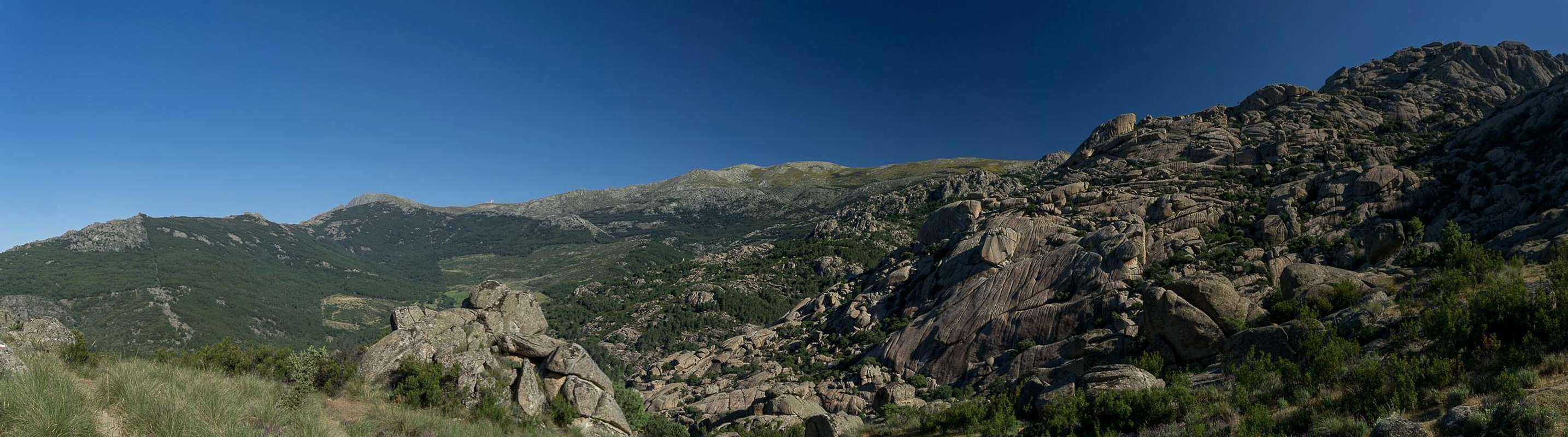
 Griffon Vulture
 A Sphinx
 El Elefantillo
 El Acebo
 Rock formations
 Pedriza Posterior
 Domeland
 Female ibex
 Ibex country
 famous towers
 La Bola de Navajuelos
 Pedriza hiking
 A maze of rock
 Domelike tower
 El Tolmo
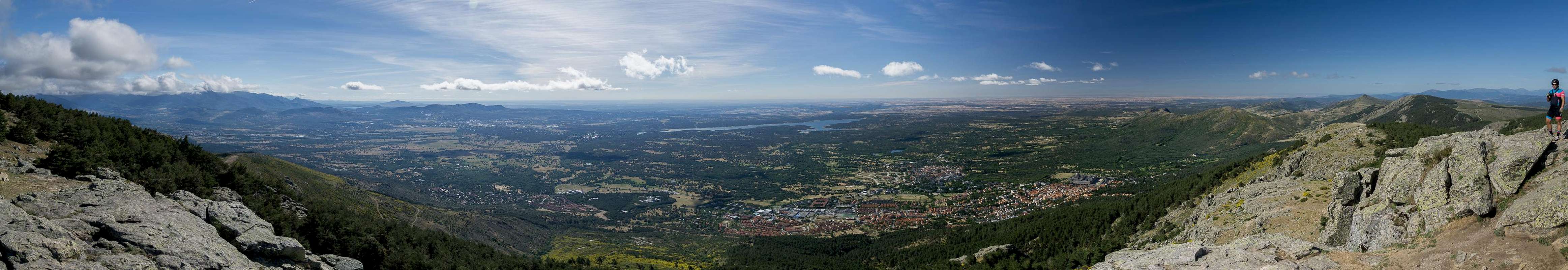
 Refugio La Naranjera
 Cuerda Larga
 Los Caidos
 Papillo machaon
 El Escorial
 Iphiclides podalirius
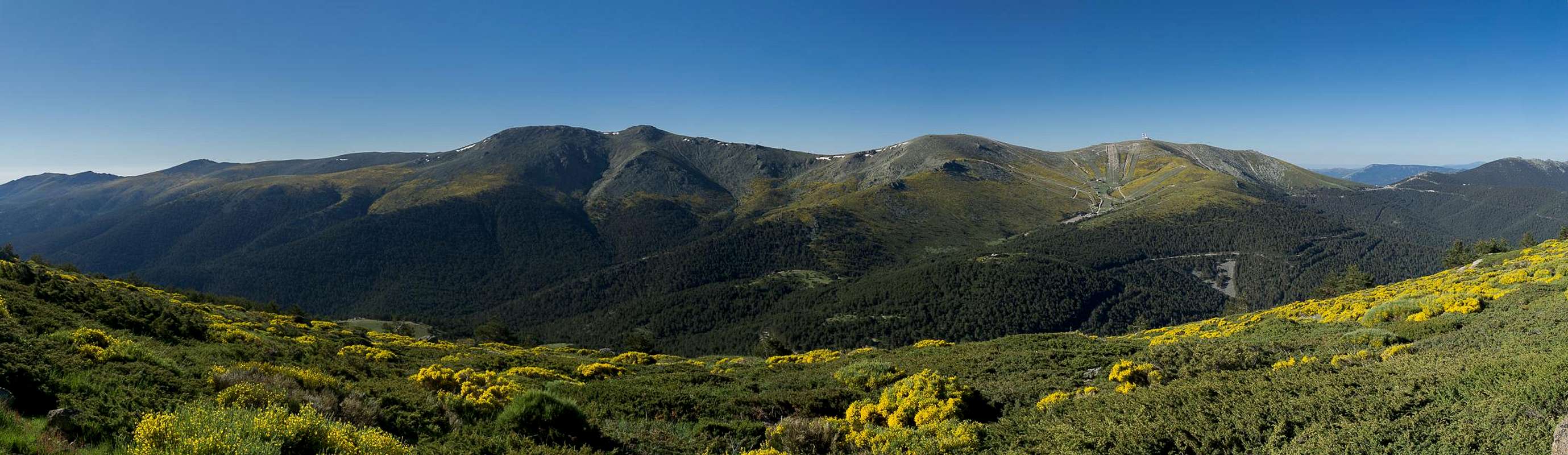
 Peñalara
 Mujer Muerta
 Siete Picos
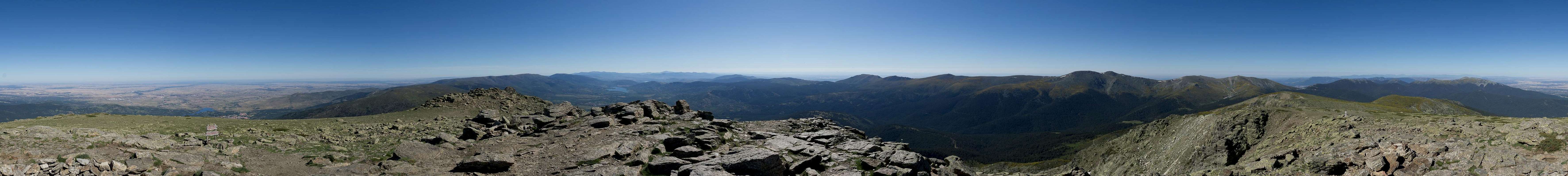
 Risco de los Claveles
 Peñalara
 Ridge Traverse
 Down on the face
 Ridge rock hopping
 Risco de los Claveles
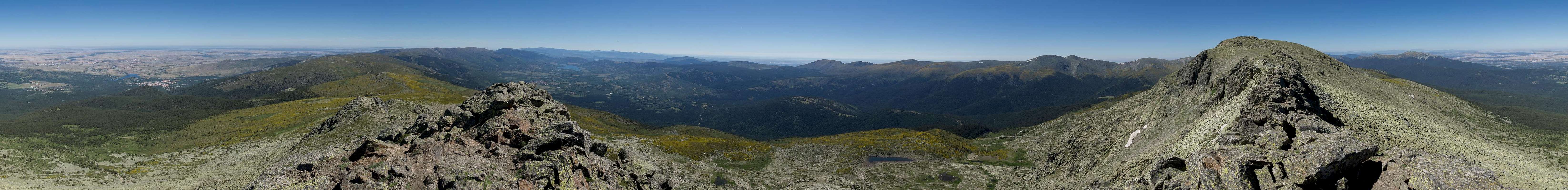
 Lagona de los Pajaros
 Lunchtime visitor
 Spanish Broom
 La Peñota, Peña el Águila
 Montón de Trigo
 Peña el Oso and La Piñareja
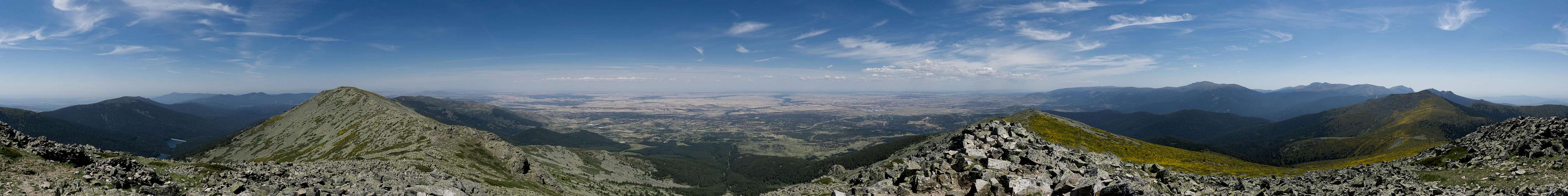
 Peña el Oso
 Bears!
 La Piñareja
 La Piñareja
 Peña el Oso
 Montón de Trigo
 Twin rocks
 On Cuerda de los Porrones
 On Cuerda de los Porrones
 La Maliciosa
 La Maliciosa
 The south-east face
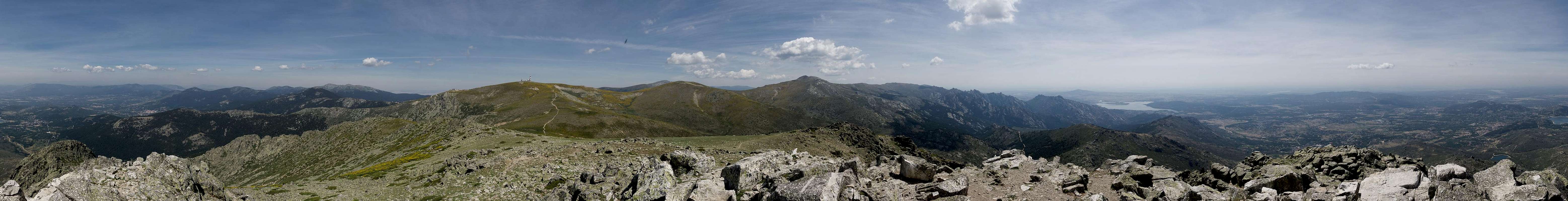
 Cuerda de los Porrones
 Granite formation
 La Pedriza
 Refugio de la Najarra
 Ibex resting place
 Coming down from La Najarra
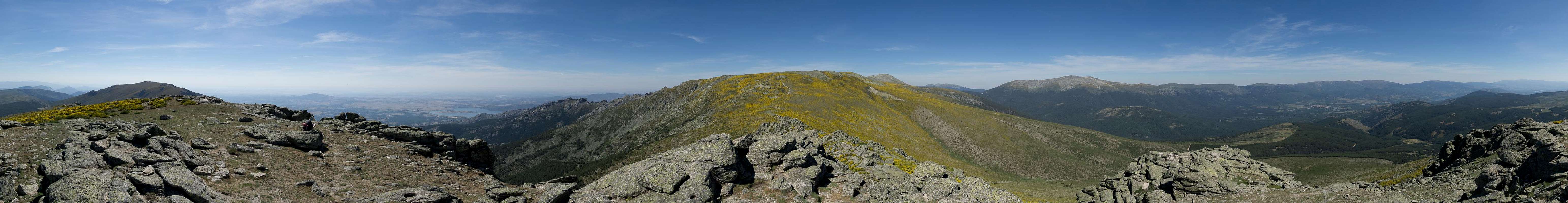
 Griffon Vulture
 Peñas Linderas
 Interspecies contact
 Los Bailanderos
 Peñalara
 Spanish Broom