Rucu Pichincha
After a successful trip to Mexico last February I thought it was time to go a little further south of the border to take a small step upwards with a trip to Ecuador. I went with Nord Sandstrom, also from Denver, and used Moggely in Quito for guides per recommendations from other SP members online. We changed our plans since originally we wanted to start with the Ilinizas, but we heard that Sur was not in very good shape so we decided to begin our trip nearer Quito with the Pichinchas. I arrived in Quito the night before our acclimatization hikes, Nord had arrived a day sooner. The three main summits of this large volcanic massif are Guagua, Rucu and Encantado (smallest of the three). Guagua Pichincha erupted as recently as 1999 sending a large plume of ash high above Quito.
We began by taking a cab to the TeleferiQo aerial tram on the west side of town en route to the summit of Rucu Pichincha. The tram starts at a small amusement park and tops out on the slopes of Rucu at around 13,000 feet.
![TeleferiQo lift]() TeleferiQo lift
TeleferiQo liftIt costs $4 for a round trip, or $7 if you want an express pass that skips the line- not necessary when we went. On the top there is an indoor observation deck, bar and small outside restaurant. A clear trail leads to the summit. Below, Quito was always visible at the valley floor around 9,300 feet.
The trail slowly gained altitude until we met the East ridge. There were a few climbers who took this route (class 4 to easy 5), but we passed it to the right and continued on the main trail until we came to a sandy slope. This slope was easy to climb by some switch-backs until we neared the summit after ~300 feet of easy class 4 climbing.
![Nearing top of Rucu]() Nearing the top of Rucu, Quito in background
Nearing the top of Rucu, Quito in background
We spent a little time on the summit and saw the summit of Guagua Pichincha not far away.
![Guagua Pichincha]() Guagua Pichincha seen from summit of Rucu
Guagua Pichincha seen from summit of RucuWe headed back down and soon were back to the TeleferiQo lift. The trip took about two hours up and one hour down. We started our hike around 10am.
Guagua summit
The next morning we were met at our hotel by Robinson, our guide from Moggely. We used a guide for this hike because we needed a ride to the Guagua trail and for the traverse route from the summit of Guagua to the Encantado summit. We were taken to the village of Lloa, where it is possible to begin a climb, and past this town to the civil defense refuge high on Guagua. We decided to go higher, because our guide thought it would be better to spend our time higher on the mountain rather than climbing it from below. He suggested the traverse over to Encantado for this purpose. We began by hiking along a short segment of road to a shrine intended to protect Quito from the wrath of its nearby volcanoes- Pichincha in particular. The trail continued along the crater edge to a rocky outcropping (up to easy class 4) to the summit. The caldera was shrouded in clouds and the smell of sulfur was ever-present.
![Guagua summit ridge]() Ridge trail to Guagua along crater rim
Ridge trail to Guagua along crater rim![Guagua summit]() Guagua summit, from left: Robinson (Moggely guide), Woodie Hopper, Nord Sandstrom
Guagua summit, from left: Robinson (Moggely guide), Woodie Hopper, Nord Sandstrom
After spending a little time on the top, we headed down in the direction of Encantado.
Encantado traverse
We headed down a sandy, ash-filled slope to the saddle between Guagua and Encantado.
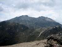
![Encantado traverse route from slopes of Guagua]() Encantado traverse route follows the trail up the center of the photo to the summit near the center, Rucu is above and to the left
Encantado traverse route follows the trail up the center of the photo to the summit near the center, Rucu is above and to the leftThe trail was easy to follow as it was well worn. The rocky ~1000 feet leading to the summit of Encantado consisted of some rotten rock at the beginning, but the last 200 or 300 feet was more stable with larger boulders. After spending a little time at the top we traversed to the road a little below the refuge and headed back to our hotel. Our hike lasted around 5 hours- we hoped it would be enough to get us ready for Cayambe in two nights! Overall these hikes were pretty easy and comfortable since we could spend the night in Quito (rather than in a hut) and have a leisurely breakfast before heading for the trails.
![Encantado summit]() Encantado summit
Encantado summit
Comments
No comments posted yet.