Toggle navigation
Mountains
Routes
Images
Trip Reports
Forum
What's New
People
Areas & Ranges
Articles
Trailheads
Canyons
Huts & Campgrounds
Albums
Logistical Centers
Fact Sheets
Lists
Custom Objects
Gear
Plans & Partners
WELCOME TO SUMMITPOST
SIGN IN
REGISTER
Winter in the High Uintas
Additional Parents
Image
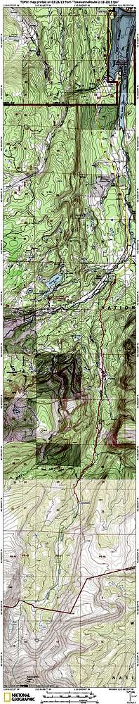
Tokewanna Topo
View High-Resolution Image
Tokewanna Topo
Yellow line is first and third days. Red line is second day. Dashed green line is wishful thinking.
« PREV
NEXT »
ZeeJay
on
Mar 26, 2013 2:03 pm
Comments & voting
Other parents
Lat/Lon:
40.80997°N / 110.62393°W
Image Type(s):
Topo/Diagram
Image ID:
843746
1186 Hits
74.01
% Score
4
Votes
Log in to vote
Comments
No comments posted yet.
to post!
Don't have an account?
Winter in the High Uintas
(Trip Report)
« PREV
Viewing
#20 of 20
GALLERY
You are at
the Last
Image
ZeeJay's Image Gallery
« PREV
Viewing
#1295 of 1388
GALLERY
NEXT »
×
You need to login in order to vote!
User Name
Password
Remember me
Forgot your password?
Log me out when I close my browser.
Keep me logged in all the time.
sign in as a user
Don't have an account?
Register now for FREE
Rating available
Suggested routes for you
People who climb the same things as you
Comments Available
Create Albums
Register Here


