Approach
This is a 4000’+/- ascent day. Travel 4-5 kms north on Big Elbow Trail from the Elbow Pass parking area and around the west side of the lake. These kilometers are very pleasant and quick. You will be in clear view of
Mount Rae’s Glacier on your right. Once you are past
Mount Elpoca on the left, Mount Tombstone dominates your northern view.
Do not wait until you are even with the southeast ridge to dispense with the trail (you have 3000’ of vertical gain to reach the summit from this point). Go ahead and angle off towards the ridge through open meadows and eventually bushwhack through some firs to reach the base of the southeast ridge. I made it more difficult as I ventured to far east below the ridge top, therefore, having to free climb 5th class rock to the ridge itself.
Route Description
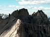
Once you have gained the ridge, there will be a multitude of narrow sections and small rock bands, but nothing overly demanding for a moderate scramble. This is a longer ridge than what depth perception would lead you to believe.
There is one steep section at about the middle where you traverse to the east (right) to avoid cliffs. It was here that I observed a Broad-Winged Hawk take flight at 9000' from the ridge. The real summit is actually the 2nd highpoint you come to. There was a register log in place in 2003. You have steep views of Tombstone lakes and a good view of the east face of Mount Assiniboine along with Mts. Lyautey, Sarrail, Beatty and
Rae.
On descent, return to the col between the two summits and run down the coarse scree and talus to the valley below. Stay to the right of this deepening runoff canyon. At the bottom, right before thick forest, there is a trail that leads back south, but you will have to bushwhack off of it at some point to head southeast back to the Big Elbow Trail. When you look back at the summit, you can now tell where you were and how it got its name.
Essential Gear
Alpine Ax if Snow Conditions Prevail, Helmet, Gaiters and Bear Spray

 3865 Hits
 72.08% Score
 2 Votes