The Glacier Gorge Traverse, Rocky Mountain National Park, Colorado

The Glacier Gorge Traverse, Rocky Mountain National Park, Colorado

Page Type Page Type: Trip Report
Location Lat/Lon: 40.25425°N / 105.61621°W
Date Date Climbed/Hiked: Oct 1, 2001
Activities Activities: Mountaineering
Seasons Season: Summer

Glacier Gorge Traverse, Rocky Mountain National Park, Colorado

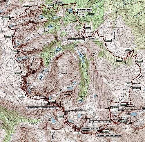
Glacier Gorge Traverse Map

July 31,1982, 9:18pm

The landscape is bathed in the light of a nearly full moon. Given the time of day the temperature is pleasantly warm. There is the usual breeze from the west.
The challenge is to traverse eleven of the high peaks of Rocky Mountain National Park in less than 24 hours. I’ve been unsuccessful in five previous attempts. I’m told others have also tried and failed.
The route begins, gently, by hiking down the trail from Bear Lake to Glacier Gorge Junction and from there up the North Longs Peak Trail to the junction with the East Longs Peak Trail at Granite Pass.
The first few miles go by with seemingly little effort. By the time I reach Granite Pass I’m so eager to ascend the first peak I leave the trail and head straight up the North Slope of Mount Lady Washington.

August 1, 1982, 2:13am

I am standing on the highest of the many large boulders adorning the summit of Mount Lady Washington. The lunar-lit landscape is spectacular. The temperature is considerably cooler than it was at Bear Lake. I descend westward into and across the Boulderfield aiming directly for the next summit.

4:40am

On top of Storm Peak, I brace against a stiff westerly breeze enjoying one of my favorite views of Longs Peak by moonlight. From the summit I head south along the east side of the ridge towards The Keyhole. The pale pinks and lavenders of first light are beginning to grace the eastern sky. The sun has just risen when I reach The Keyhole. I ascend Longs the same way I have many times before via The Trough and Homestretch.

7:10am

I reach the familiar summit boulder on the flat summit of Longs Peak for the 72nd time in my life. Unfortunately, there isn’t time to pause and enjoy the view because the difficult parts of the traverse still lie ahead and must be finished during daylight.
I descend Homestretch, and instead of heading back across the Narrows, I continue on down towards the col between Longs and Pagoda Mountain. Having been this way three times before I know there is a short headwall part way down which requires a rappel.
I head directly for my previous rappel point, find it and use the same piton anchor I placed in 1970. The rappel is only about forty feet, so I’m soon on my way down to the col and up the East Ridge of Pagoda.


10:19am
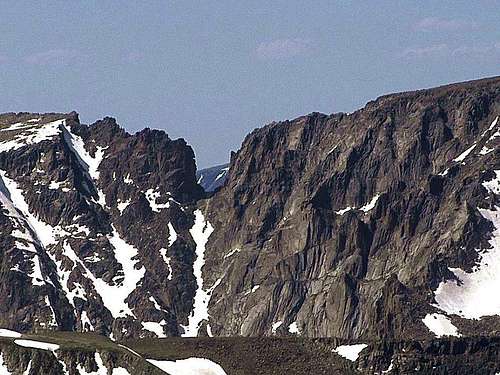
The  airy  West Ridge of Pagoda

I’ve been moving continuously for thirteen hours when I reach the summit of Pagoda Mountain. Before beginning the descent of the West Ridge of Pagoda, which is the most difficult section of the entire traverse, I stop for a short rest and a bite to eat.
The West Ridge begins with about 150 yards of down climbing along the very narrow and exposed crest to the first in a series of vertical steps. At the first step I locate my previous rappel anchors, check them carefully to see they are still solid, replace the old frayed nylon runner with a new one, setup the rope, clip it into my figure 8 ring and ease over the edge onto Pagoda’s north face. This is an airy place. The floor of Glacier Gorge is over a thousand feet below. Just as I’m about at the ends of my rope I reach an almost hidden narrow ledge, which I know, is there. I recall the excitement of the first time down this rappel when I didn’t know the ledge was there and contemplating the possibility of climbing hand over hand back up the rope for 75 feet. Balanced on the six inch wide ledge I hold on to the rock with my right hand and pull down the rope with my left hoping that it doesn’t get caught. It clears the anchor and falls cleanly down around me and onto the face below. I put the rope in my teeth and traverse to where the ledge is wide enough to stand comfortably and recoil the rope. The next step on the ridge is almost a repeat of the last except the rappel is easier. After two more rappels and I’m at the beginning of an exposed ledge system that crosses the steep slabs of the north face heading to the col between Pagoda and Chiefs Head Peak.
At the col I meet another climber who has climbed up from Glacier Gorge and we hike together for a ways. When he finds out what I’m doing he says he is impressed, but in his expression I seem to detect he is harboring doubts about my sanity.

1:43pm

I reach the friendly summit of Chiefs Head, the third highest peak in The Park. After signing the summit register I follow the ridge downward as it curves northwest towards the next peak. At Stoneman Pass, where my companions and I had given up on two of the previous attempts, the temptation is strong to bail out again.
“I’m tired and thirsty,” my body is screaming, “rather than climb the remaining six peaks, it would be so much easier to descend to Black Lake and hike back out on the trail.”
This time love of folly triumphs over good sense and I begin the climb up the south ridge of McHenrys.

4:22pm
The McHenrys Notch

I’m standing in the beautiful late afternoon light looking down into the upper reaches of Glacier Gorge from the summit of McHenrys Peak. I’d match this magnificent alpine scenery against any in the world.
As I’m leaving the summit a loose rock rolls under my foot and I fall hard on my left knee. Shaken, I sit and examine the damage. Although, there is a nasty laceration the kneecap doesn’t seem to be broken so after applying some first aid I’m on my way climbing down into the McHenrys Notch. In 1966 when I tried the Traverse for the first time, we began with Flattop Mountain and were coming from north to south when we crossed the Notch. On that occasion we did a couple of roped leads climbing out of the Notch on the McHenrys side, so I’m anticipating three or four rappels to get down. Much to my surprise I’m able to downclimb almost all the way, using only one short rappel.
From the floor of the Notch I have just begun the scree and talus scramble up towards the summit of Powell when I find a trickle of water running from a snowbank. It’s time for something to eat and some much needed rehydration.


6:07pm

I finish the climb to the summit of Powell Peak. At this point all the technical sections are behind me, there are only four more relatively easy summits left to go, but it’s apparent I’m not going to make the Traverse in under 24 hours.
The hike from Powell to Taylor is a long mile across tundra and talus.

7:22pm

I summit Taylor Peak and, without stopping, hurry on down towards Andrews Pass. The sun is nearly setting and I want to get as far as possible during daylight.

8:57pm

I’m on top of Otis Peak. Without benefit of either daylight or moonlight I turn on my headlamp and set out towards Hallett Peak.
On the way I find another trickle of water and stop for a break. The moon is up now. The sky, clouds, shapes and textures of the alpine landscape are a study in soft shades of gray and velvet blacks. From this vantage point I can see most of the summits I’ve visited in the last 24 hours, and it finally registers in my tired mind, the Traverse is almost finished. There is an almost overwhelming sense of satisfaction.

10:14pm

It’s all downhill from here. I’m on top of Hallett Peak knowing all that remains is to descend around the head of Tyndall Gorge to the summit of Flattop and hike down the Flattop Trail to Bear Lake. Hallelujah!

10:49pm

I reach the broad summit of Flattop Mountain and immediately set off down the Flattop Trail to finish the remaining four and a half miles.
The sky, containing more clouds than normal for this hour of the day, erupts into a thunderstorm.
I’m thinking to myself Mother Nature has a cruel sense of humor. I can hear her saying, “Okay smart guy, you just climbed eleven peaks, now let’s see if you can run a couple of miles to avoid being zapped by lightning.”
Desire for survival overcomes lack of energy and I run down to below timberline. The extra effort takes its toll. I’ve been moving for over 26 hours and the level of fatigue is becoming oppressive.

August 2, 1982, 1:08am

Finally, I’m back to my good ol’ VW bus at the Bear Lake parking lot. It has taken 27 hours and 50 minutes. To my surprise, my friend Howard Pomranka, is there waiting to make sure I return safely. Earlier in the day he missed connecting with me at Andrews Pass in hope of climbing the last three peaks together.
He knows the history of the five previous attempts. He looks at the tired smile on my face and his first words are, “You made it didn’t you?”

I reply, “Yes. It’s finally finished.”

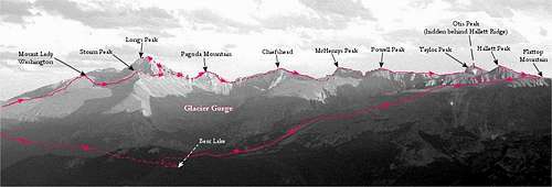
The Traverse ascends in order:
1. Mount Lady Washington, 13,281 ft.,
2. Storm Peak, 13,326 ft.,
3. Longs Peak, 14,259 ft.,
4. Pagoda Mountain, 13,497 ft.,
5. Chiefs Head Peak, 13,579 ft.,
6. McHenrys Peak, 13,327 ft.,
7. Powell Peak, 13,208 ft.,
8. Taylor Peak, 13,153 ft.,
9. Otis Peak, 12,486 ft.,
10. Hallett Peak, 12,713 ft.,
11. Flattop Mountain, 12,324 ft.

It is 23.01 miles long and has an elevation gain/loss of 11,447 ft..


James Disney
February 13, 2006
Glacier Gorge Traverse route


Comments

Post a Comment
Viewing: 1-18 of 18
Andy

Andy - Feb 13, 2006 10:10 pm - Voted 10/10

I'm curious why...

...you didn't go up Longs' North Face? It seems like it would have been faster and easier (effort-wise) than the Keyhole Route. Great trip report about a HUGE effort!

Mountain Jim

Mountain Jim - Feb 13, 2006 11:56 pm - Hasn't voted

Re: I'm curious why...

Actually, it's about the same amount of effort to get from Storm Peak over to the base of the old cable route ... and besides I wanted to leave my pack and rope at the bottom of Homestretch and pick them up on the way to Pagoda.

Andy

Andy - Feb 14, 2006 8:14 pm - Voted 10/10

Re: I'm curious why...

Cool. I guess I hadn't thought about zig-zagging back and forth across the Boulder Field. Now it makes sense that if you did Lady Washington first, when you're on top of Storm that you're pretty much at the Keyhole. An amazing day for sure!

MrWasatch

MrWasatch - Feb 14, 2006 8:58 pm - Hasn't voted

Well done!

Great report. Sounds like an incredible route!

Brad Snider

Brad Snider - Feb 20, 2006 7:53 pm - Voted 10/10

Congratulations!

I had wondered about the possibility of something like this, but to do that traverse without stopping to camp--incredible! And to try it six times! I loved reading this inspiring trip report. Also, I have enjoyed many of the pictures you have added to SP. Thanks for the inspiration!

Mountain Jim

Mountain Jim - Feb 22, 2006 4:14 am - Hasn't voted

Re: Congratulations!

Thanks for your appreciation ... at my age it's nice to feel useful ... Looks like you've done quite a bit ... keep on fightin' gravity.

Chris

Chris - Jun 12, 2006 8:08 pm - Voted 10/10

Wow.

Wow... that's about all I can say about this one... sounds like an awesome epic! Great job!

Mountain Jim

Mountain Jim - Jun 13, 2006 1:46 am - Hasn't voted

Re: Wow.

Thanks. Looks like you've done a lot of good climbs, also ... good job to you, too !!!

coloradoclimber

coloradoclimber - Aug 11, 2006 10:24 pm - Hasn't voted

amazing loop Jim

I'll have to try that sometime! What would you rate the ridge on Pagoda if you were going the opposite direction from Chiefs Head?

Mountain Jim

Mountain Jim - Aug 12, 2006 5:19 am - Hasn't voted

Re: amazing loop Jim

Thanks. I've been down the ridge 4 times, but I've never gone up. Friends who have, and an old guide books say it's in the 5.7 range. If you're in Estes Park stop by Komito Boots and ask Steve Komito about the route. He and Tom Hornbein climbed it a few years ago.
Just one other thought ... the first time I tried the traverse, I was going the other way. The second time, I attempted it the way described in the trip report ... the reason I changed directions was to get the higher peaks and the harder parts done while you still have energy.

Dottie Little Tent

Dottie Little Tent - Mar 6, 2007 11:05 pm - Voted 10/10

Nice

Can a person backpack while doing this route?

Mountain Jim

Mountain Jim - Mar 7, 2007 3:22 pm - Hasn't voted

Re: Nice

It would be difficult to backpack this route because there aren't any designated back country sites above timberline or nearby, and doing the technical sections with a big pack would be a challenge.
Peace, Jim

tomlauren

tomlauren - Jun 29, 2008 8:41 pm - Hasn't voted

Incredible

Have you heard of any others who have repeated the Glacier Gorge Traverse? If so, any ideas of what the current time record may be?

Mountain Jim

Mountain Jim - Jun 30, 2008 3:49 pm - Hasn't voted

Re: Incredible

I know of one other party that sort of repeated the route ... they avoided the West Ridge of Pagoda by dropping off into Glacier Gorge, and the McHenrys Notch by dropping into the North Inlet Valley ... I don't know what their elapsed time was.
And, an SPer tried it a year, or so, ago going the opposite way and got stopped by the West Ridge of Pagoda. I think he posted a trip report.
Peace, Jim

John Prater

John Prater - Jul 6, 2008 12:25 am - Hasn't voted

Re: Incredible

Bill Briggs did a version of the Glacier Gorge Traverse that included Longs, Pagoda, Chiefs Head, McHenrys, Powell, and Taylor. Incredibly, he completed this in 7:17 (source).

Bill Wright and I did the reverse route (Flattop, Hallett, Otis, Taylor, Powell, McHenrys, Chiefs Head, Pagoda, Longs, Storm) today (7/5). Needless to say, it was hard! Finished in 13:55. Bill Briggs' time for this loop is phenomenal.

Correction: Bill Briggs' loop did not include Storm, Otis, Hallett, and Flattop. His time is still unreal.

tomlauren

tomlauren - Jun 29, 2008 8:47 pm - Hasn't voted

Other insane combos?

Jim, do you know of a good source information about other insane RMNP link-ups? Others that I know of are:

1. Longs Peak Radical Slam
2. Longs Peak Grand Slam
3. Mummy Kill 8 Peak Version
4. Mummy Kill 6 Peak Version
5. McHenrys Notch Loop

If such a list doesn't exist, you're probably the best qualified person to create one. I'm sure that it would get a lot of attention, and maybe generate some grand ideas for some wild adventures.

Mountain Jim

Mountain Jim - Jun 30, 2008 4:06 pm - Hasn't voted

Re: Other insane combos?

I think there are trip reports here on SP on some of the ones you mention.

I have a couple more that I may write up one of these days, including a south to north traverse from the Sand Beach Lake Trailhead to the Glacier Gorge Trailhead across Lookout Mountain, Mount Meeker, to Longs (across The Notch), then down the Keyhole Ridge to the Keyhole and on to Storm Peak, and then down Storm's North Ridge to Half Mountain. And, another you might be interested in was from the House Rock Road (east of Meeker Park) to the Lily Lake trailhead via all the "summits" on Twin Sisters.

My son, Dave, has done a some of impressive ones ... like the peaks of the Never Summer Range from Static Peak to Baker Mountain in 17 hours.

Glen Porzak & friends stayed right on the Continental Divide through The Park, which included doing the McHenrys Notch and the North Ridge of Isolation. I think theirs was a multi day trip.

Bottom line ... people have done some crazy things in The Park.

Peace, Jim

pbakwin - Sep 13, 2015 10:57 am - Hasn't voted

GGT

This is similar to Rossiter's "A Walk in the Park". I've summarized these 2 routes & their fastest known times (FKTs) here:
http://fastestknowntime.proboards.com/thread/324/glacier-gorge-traverse-c0?page=1&scrollTo=3315
It's confusing because "A Walk in the Park" traverses Glacier Gorge proper, while this route ("Glacier Gorge Traverse") traverses Glacier Gorge, Loch Vale, Chaos Canyon and Tyndall Gorge.

Viewing: 1-18 of 18