![Mt. Holmes]() Mt Holmes
Mt HolmesDay two of our peakbagging week.
If you read my trip report for
Mount Hillers, you know a bit of the background of why we were there. Rather than repeat that information, I'd refer you to that trip report. After an interesting evening the night before and being serenaded by a guitar player who couldn't sing, we were ready for our next goal, Mt. Holmes.
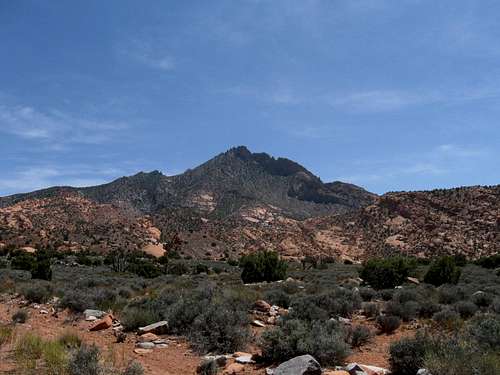
Mount Holmes to me is probably the most interesting of the peaks I've visited in the Henry Mountains. Missing being 8000 feet tall by a mere two feet, it has the smallest summit of any of the main peaks in the Henry's and it is the mountain with the least amount of elevation. Utilizing the information that
Greg put together, we had an idea of what we were going to do. Before I go into our hike of this mountain, let me quote a couple of things from Greg's fine page for Mount Holmes:
"From any distance, Mount Holmes is impressive; it has a several hundred foot high summit block with a sheer west face that will make your head turn as you drive by on highway 276. The actual summit is furthest east and cannot be seen from the closest stretch of 276 directly west. The summit is difficult to determine until you are actually on top of it, even while hiking up, the intimidating western summit block looks highest"
Then Greg goes on to say this:
"Getting to the summit Mount Holmes is unique and scenic and steep. First you will pass by a sandstone wash (similar to a slot canyon), then ascend a sandstone ridge which turns into granite higher up. Route finding along the ridge is fairly easy, unfortunately, depending on your skills, the entire route to the summit can be kept at only class 2, though you will probably run into some short sections of class 3. Nonetheless, Mount Holmes is a fun hike with excellent scenery."
That was a good intro and we noted all of the above on our effort. Greg has also put together a good route page that also includes a map, and so I can say, short of climbing this peak for us, Greg really showed us the way. We did find a variation of his route on the way down but more on that later.
![Mt. Holmes]() Andy in the slickrock Andy in the slickrock | ![Mt Holmes]() colorful rock colorful rock | ![Mt. Holmes]() we went left we went left |
The hiking effort
Thanks to Greg's description, we knew we had 7 miles roundtrip and 3000 feet of elevation gain ahead of us. Not too bad and that didn't sound too hard or intimidating. The key would turn out to be the routefinding aspect but with Andy Martin along, that would prove to be a cake walk. Andy has an intuitive ability to find the correct way. Not once during our day or days ahead did he err. He could literally smell the route out and on Mt. Holmes, that ability came in very handy.
We drove back to the highway (276) and turned left, back towards Hanksville but only for a relatively short distance. Greg even had GPS coordinates for
where to park on his route page for the
North Ridge
Following Greg's instructions:
"Once you are on 276, near the start of the hike, the best place to park is just north of the start of hike point. About 1/3 a mile north of this starting point on 276, is a large pull off area on the west side of highway 276, park here.
Once parked walk south 1/3 a mile on 276 to the wash, you will ascend a small hill then descend it on 276 to the wash. Once in the wash follow it for 0.15 miles eastward to the start of the 4WD trail, listed above. Follow this fading 4WD trail as it starts to head towards Mount Holmes, then begins heading north towards an area with sandstone walls. The 4WD trail enters this area, and then ascends a notch where it ends. The 4WD Trail is about 1.25 miles long."
Those instructions worked great for us and so did the
pic and the
map that Greg posted to show the route. Once above the end of the road, we began to pick our route towards the peak's summit. There isn't a trail nor is it cairned but it isn't difficult to figure out which way is the best to go as you just keep heading up, although we had several places where we did have to drop down in order to find the best line through the slickrock and sandstone section. Greg gave another key in his route report: "At about 6200 feet traverse to the east side of the sandstone “
bump” to avoid unnecessary elevation gain." Armed with that tidbit of info, Andy pretty much could feel the route from the moment we got off of the sandstone and encountered the granite. Once again, Greg shined with with the info he provided: "Once around the bump you will have a good view of the rest of the way up (see
Greg's pic). As the sandstone ends and the granite starts, there is a set of pinnacles to go around, traverse to the east side (left) of this. There are several chutes that look like they will take you over and around but most will be dead ends on a cliff." Andy nailed the rest of the way and while I thought the chute probably was probably high class 2 (still easy), it ends near the summit and you have a little traverse to get you over to the summit which is only big enough for one person to sit on. None of my pictures captured that little traverse but while Andy read the small register, I sat about twenty feet away from him and enjoyed the views, particularly the one that looked over at Mt. Ellsworth, our object for the next day.
When Andy was through with his turn on the summit, I went over and had my chance to read and sign the register. Placed originally by Gerry Roach of 7 summits fame (2nd person to do those), it was really just a couple pages of paper that others had signed. Hopefully, a future visitor will take a new register up to hold both the old pages and begin a new one. I took some pics while on the summit but it was soon time to re-join Andy who had worked his way back down to the bottom of the chute.
Our descent was the same on the granite portion of the mountain but once we hit the sandstone, it was time for Andy to spring back into action. As we took a break, he poured over the map and I could see the light bulb turn on in his eyes. He wondered out loud, "Hmmm, I think this might be better". Sharing his thoughts with me, he outlined his idea about not going back the way we came up but taking a more direct way that would bypass much of the notch route (end of 4WD road) and instead, tie into that road way down in the flats. The risk he felt was that his new route might get cliffed out and we'd have to hike all the way back up to the spot we were at and go back the original way. I looked at the map and I could see where he was thinking about going and it looked like a winner to me. We left the normal route at the elevation of 6285'. GPS coordinates: 37.8085 -110.5811 (nad27)
It worked, it worked like a charm. From the spot we cut off the original route, the way down led almost seamlessly to the road. Would I take it back
as a way up if I ever return to visit Holmes again you might ask? The answer is yes but for others doing for the first time, I'd probably recommend that you stick with the directions provided by Greg. They worked well for us.
Once we hit the 4WD road, it was pretty much an easy hoof back to my truck. In case you are wondering why we didn't drive that 4WD road, my answer is, you wouldn't want to. It is washed out badly near the beginning and that is a stopper. Just park off the side of the main highway and use the route that Greg outlines. It worked great for us.
![Descent route]() Greg's map & our route
Greg's map & our route
Total mileage: 7 miles
Elevation (including gain & losses) 3500'
Time spent: about 8 hours (includes summit time & generous breaks)
Others can most likely do this much faster but we were thinking ahead to the fact that we had many more hikes to do, with a 21 miler waiting for
us at the end of the week so keeping our legs fresh was an important consideration.
The end of the story
We had kept in the back of our mind the possibility of doing both Mt. Holmes and Mt. Ellsworth on the same day but decided we didn't actually want to do that after we got off of Mt. Holmes. We felt we would be better served if we saved Ellsworth for the next day and went back to the Starr Springs campground and just relaxed for the rest of the day and study out a plan to do both Mt. Ellsworth and Lands End. Lands End is a long drive but I'll explain all of that on the trip report I create for Mt. Ellsworth (upcoming). Also on the same trip we did San Rafael Knob and Mt. Elliot and my goal is to get trip reports put together for those before the end of January.
While back in the campground we found to our relief that our elderly "friend" from Texas who had regaled us with stories from yesteryear and his interesting guitar playing and singing had moved on. Instead, we met a younger man who turned out to be a fire lookout from California who spent his free time in this part of Utah before taking on his lookout duties. He mentioned that the year before he'd spent part of a week in the Maze, pretty much lost for a couple of days. He said he entertained himself during that time by reading the wrappers of food items. A nice guy and he had wondered about the bad singing coming from our side of the campground. We assured him, it wasn't us.
I know, I didn't tell you the full story about the guy who drove up (see the end of the Mt. Hillers trip report) and asked to join us (he was lonely).
We spent another great night at the Starr Springs Campground and realized that tomorrow we'd be camped somewhere else.
5 days in southern Utah:
FIVE DAYS OF HIKING
Day one - Mt. Hillers
Day two - Mt. Holmes
Day three -
Mt. Ellsworth as well as
Land's End
Day four -
San Rafael Knob
Day five -
Mt. Elliot
![Mt. Ellsworth]() Mt. Ellsworth
Mt. Ellsworth![Looking towards]() Mt. Holmes from Mt. Ellsworth
Mt. Holmes from Mt. Ellsworth


Comments
Post a Comment