Trip overview
A loop ski tour from Upper Setting winter TH over Duke Mountain (10,605) thence East along the crest of Western Uintas over summits 10,183, 10,093, and 10,450 a.k.a. West Shingle Peak.
Our route went across Coop Creek, Yellow Pine, and Shingle Creek watersheds on the South side of the divide, and Box Canyon over to the North.
Ca. 18 miles RT, 4200 ft elevation gain.
Duke - the Sentinel of Western Uintas
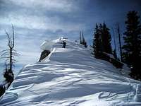
![View from the traverse off Upper Setting]() Starting the traverse towards Yellow Pine
Starting the traverse towards Yellow Pine
Rob, Judy, and myself started 9-ish "new time" from Co-op Creek TH, the pullout was full of sledheads who told us that they've also tracked all of the area up there the previous weekend. They passed us half mile up Upper Setting road, waved hands, and we didn't see or hear or smell them ever again. The 'bilers must have been an experienced bunch of snow-poachers, since we've later spotted their tracks in Shingles and up the slopes of Wall Peak and over in Erickson Basin (all of these off-limits to motorized travel, unlike motor-legal Coop creek) and it should take pretty confident routefinding skills to get a snowmachine over there through the wooded, steep, roadless country West of Shingle Creek. It looks like the guys used a bench below the summer trail to get up there.
We've left the road
at the big hairpin and traversed towards Yellow Pine. The ridge separating us from Yellow Pine creek was all snowless at this elevation, so we ascended a nice little gully to 8,500 el and crossed there.
![Ski shortcut from Yellow Pine creek]() Ascending out of Yellow Pine Creek to the lakes
Ascending out of Yellow Pine Creek to the lakes![Upper Yellow Pine Lake]() Upper Yellow Pine Lake and the escarpment of Duke
Upper Yellow Pine Lake and the escarpment of Duke
We dropped couple hundred ft on a gentle traverse and intersected Yellow Pine trail just short of the creek crossing. So we barely travelled a hundred yards on the track there - not that it mattered, a bit of snow over supportive crusts made travel a blast.
Of course we didn't care to cross to the East bank with the trail. Just skied along the edge of the woods parallel to the creek, then, as the terrain got steeper and more forested, cut left and up to intersect the summer Yellow Pine Lakes spur trail at the bottom of a little aspen bowl at 9,300. Turned due West and topped the rim of this bowl, where we stopped for a snack and skin-waxing break with a fantastic view of Castle.
From there, the pines were opening up, and the red cliffs of Duke showed us the way.
![Ascending the ridge above Y P Lakes]() Up the ridge above Yellow Pine Lakes Up the ridge above Yellow Pine Lakes | ![Upper Yellow Pine Lake underfoot]() The Upper Yellow Pine Lake underfoot The Upper Yellow Pine Lake underfoot | ![West Ridge]() Into the jumble of drifts of the West Ridge Into the jumble of drifts of the West Ridge |
Passed above the lower lake and across the upper one, gained the ridge of Duke, followed it for another 500 ft vertical, and took the skins off as the terrain was finally getting less steep. But not necessarily easy! The wind forced most of the snow off NW facing slopes, forming a maize of drifts, fins, and cornices along the ridge. Very nice to photograph it but not always nice to get across them!![Now that s kings Peak training :)]() 10,600+, feels good! 10,600+, feels good! | ![Curly cornices of the West Ridge]() Cornices of West Ridge of Duke Cornices of West Ridge of Duke | ![Duke summit view]() Judy on the summit, with Timp far beyond Judy on the summit, with Timp far beyond |
![Cornices on the crest of Duke]() Corniced summit ridge, with the South Wasatch on the skyline
Corniced summit ridge, with the South Wasatch on the skyline![Sunny sheltered spot behind the drifts]() The summit - view East along the Uinta crest
The summit - view East along the Uinta crest
We stopped for lunch in a sheltered cove behind some supersize drifts on the top of Duke. The distance of the views was amazing, entire Wasatch Range from Provo Peak to Willard, Logan area mountains futher North, dark cliffs of Hayden peak on the Eastern horizon. No wonder, since Duke Mountain is unrivaled by height on the Western flank of Uintas. Nothing rises taller than this peak within 5 miles around!
![East ridge of Duke]() Skiing down East ridge
Skiing down East ridge![Descending East to Saddle 10,350]() My ski didn't like this little steep section at all
My ski didn't like this little steep section at all
The first downhill section East of Duke was badly wind-scoured and it was very encouraging to see how Judy was tackling this beautiful ugly terrain (fun to look at it, not so much to ski it). Way to go! Then, on the "second summit" (10,500), we were treated by a powder ride through
a mini-canyon between curly drifts fringed with glistening curved-dagger icicles. A fun little place!
We didn't dare to drop to steep North-facing slopes yet, and the ridge presented another maze of drifts to negotiate on the way down to Saddle 10,350. That's where yet another edge of my skis gave way with a gunshot CRACK! For a second I thought the entire ski broke, but of course it was an edge problem yet again ... these skis didn't skip a tour lately without a popping edge or two, but to see a freshly epoxied piece of edge snap in two ... that was something new indeed.
![Powder-filled mini-canyon on Duke s 2nd summit]() Powder gully tucked behind the drifts off 2nd summit Powder gully tucked behind the drifts off 2nd summit | ![Grr, another edge problem!]() Ski edge snapping out? Not again! Ski edge snapping out? Not again! | ![Headwall of Box Canyon]() We crossed the headwaters of Box Canyon here We crossed the headwaters of Box Canyon here |
Down at the saddle, as if we needed a reminder that our last year's traverse of the South side was a big mistake, there was a small cornice drop avy right where we struggled up the slope almost exactly a year ago. This time we chose a glide NE to the Box Canyon divide, then a nice short powder run into, and along, a gully curving right around the steep ridge spur, and an equally pleasant traverse further right towards the base of Box Canyon Pass.Ridge Run to West Shingle
![Looking back at Duke]() Looking back at Duke
Looking back at Duke![Box Canyon]() Box Canyon and Windy Ridge to the North
Box Canyon and Windy Ridge to the North
From the meadow at the North side of Box Canyon Pass, we topped Hill 10,183 and stopped for a map session and to evaluate our options.
We couldn't see Castle Peak (10,234), some 3/4 mile to the SW, behind the trees, but from the ridge of Duke we noted that its West side is almost stripped of the snow by the wind. This winter classic peak, giant Duke's little brother, just didn't look terribly attractive today. Meanwhile, up ahead, the flat-topped Peak 10,450 (dubbed West Shingle Peak) looked like a neat spot to cap our long traverse.
![Last summit of the day!]() West Shingle Peak, at last! West Shingle Peak, at last! | ![Hells Kitchen]() View into hidden Hells Kitchen View into hidden Hells Kitchen | ![Long, Cone, and Wall Peaks]() Long to Wall, all peaks in the heart of Western Uintas Long to Wall, all peaks in the heart of Western Uintas |
![Summit view at West Shingle Peak]() Warm and sunny at the 10,450 summit
Warm and sunny at the 10,450 summit![Telephoto shot of Easter Island pillars]() "Easter Island Giants" across the valley
"Easter Island Giants" across the valley
We continued on the ridge through Hill 10,093. The 500 ft elevation took a surprisingly serious effort to gain, this being 3 pm of a long day, but finally we enjoyed a view across Shingle Creek towards sunlit Easter Island Pillars, and at the entire length of Box Canyon escarpment to the NW, and even into the hitherto-unseen Hells Kitchen to the NE.
The descent to the Saddle 10,125 and then to the skiers' left to West Shingle Lake wasn't as fun as the ride in upper Box Canyon. The snow was getting more crusted on this side.
![Starting descent NE from West Shingle Peak]() Start of descent to West Shingle Lake Start of descent to West Shingle Lake | ![Judy descending to West Shingle Lake]() Final leg of descent to West Shingle Lake Final leg of descent to West Shingle Lake | ![West Shingle Lake and Peak]() Looking back at West Shingle Peak Looking back at West Shingle Peak |
![West Shingle Peak]() Long glide down to Upper Setting road
Long glide down to Upper Setting road
There were fresh snowmobile tracks on the lake and we agreed that instead of continuing down Shingle, we will return by their tracks and Upper Setting Road. We crossed the lake to the South-West, to discover the 'biles track loop back, and that we actually don't care that much about them. It was an easy glide through the woods, although of course we worried about finding the road. We skirted a cliff band on the East and reached an unmistakeable glade at 9,700, but the road wasn't there. Actually checking the satellite imagery the next day showed that the summer trail wasn't really supposed to be there - it is a couple hundred ft further South. And the main logging road doesn't go this way at all. Instead, it turns NW above the unnamed lake, then switches back to the East to the 9,900 ft-high bench under the cliffy bow of West Shingle Lake Peak.
Anyway, we kept gliding WSW across overgrown former clearcuts, and in a couple minutes hit the elusive road at last. And then it was miles of nearly effortless glide to the car - save for a little uphill section where the road crosses from Shingle Lake drainage into Coop Creek. These 150 ft to gain felt like a major feat now :).
Back by the car in the broad daylight, everything so warm except for the well-stashed beers of course, this spring skiing feels sooo good :) Looks like 18 miles RT, and quite a few of these miles above 10,000 which as you know defines "Kings Peak training" for me :) 4,200 ft vertical. 9 hours trip
Comments
No comments posted yet.


 Up the ridge above Yellow Pine Lakes
 The Upper Yellow Pine Lake underfoot
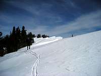 Into the jumble of drifts of the West Ridge
 10,600+, feels good!
 Cornices of West Ridge of Duke
 Judy on the summit, with Timp far beyond
 Powder gully tucked behind the drifts off 2nd summit
 Ski edge snapping out? Not again!
 We crossed the headwaters of Box Canyon here
 West Shingle Peak, at last!
 View into hidden Hells Kitchen
 Long to Wall, all peaks in the heart of Western Uintas
 Start of descent to West Shingle Lake
 Final leg of descent to West Shingle Lake
 Looking back at West Shingle Peak