
-
 7145 Hits
-
 83.69% Score
-
 17 Votes
|
|
Route |
|---|---|
|
|
34.20480°N / 118.0639°W |
|
|
Hiking, Scrambling |
|
|
Spring, Summer, Fall, Winter |
|
|
Most of a day |
|
|
Mostly trail |
|
|
Overview

The Upper Little Santa Anita Canyon Loop leads up the Mount Wilson Trail and Connector Trail to Jones Peak (3,375') and further via the Hastings Peak (4,000') ridge to the Mount Wilson Toll Road. From here the climb ascends the southwest ridge of Mount Yale (4,760'). From its summit immediately south across Mount Harvard (5,441') beautiful views at the San Gabriel Mountain Front Range await. After descending the Mount Yale southwest ridge back to the dirt road the trail continues around the south flank of Mount Harvard on the Mount Wilson Toll Road to the intersection with the Mount Wilson Trail, which leads down the Little Santa Anita Canyon back to the Connector Trail completing the loop in the upper Little Santa Anita Canyon. From here follow the trail back to the trailhead. The route described here totals to about 16 miles with ~5,100 feet of elevation gain and for most people will be an all-day hike. Pages describing the peaks and different routes (created by Mountain Impulse) can be found here (Jones Peak) and here (Mount Yale).
Getting There
Take the 210 Freeway towards Pasadena and exit on Baldwin Avenue in the city of Sierra Madre. Continue north to East Mira Monte Avenue. Turn left and continue to the trailhead (960'); park on the street. No Adventure Pass is required here.Route Description
From the trailhead (960') take the road up until the dirt trail begins. The trail steadily leads up the lower reaches of the Little Santa Anita Canyon. As of August 2008 this portion winds up the scorched slopes of the canyon, remnants of the Sierra Madre fire in April 2008. There is no shade along this part. After about 1.5 miles you reach a small side trail (~1,975') leading down to First Water, a popular and beautifully shaded picnic spot at the canyon bottom. After another 1.2 miles, partially shaded, you reach the intersection with the Connector Trail (~2,720').
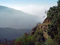
Now the narrow trail steeply ascends the west slope of the Little Santa Anita Canyon. There is no shade on this portion. You will make about 600 feet elevation in less than 0.5 miles (about 27% grade). After this steep portion you reach a plateau area (~3,350') just north of Jones Peak. From here beautiful 360 degree views open up over the foothill communities and the San Gabriel Front Range. A short trail leads from here first down (about 100 feet) into a saddle and the up to the summit of Jones Peak (3,375'). Turn back to the plateau area and continue along the beautiful ridge with marvelous views through fields of California Buckwheat over several bumps for about 1 mile to Hastings Peak (~4,100'). After Hastings Peak the trail descends about 100 feet before it steeply ascends (250 elevation gain in less than 0.15 miles, about 30% grade) to reach the Mount Wilson Toll Road coming from Henninger Flats. You are now at about 4,290' elevation and 4.6 miles from the trailhead. Turn west (left) and continue slightly downhill until the roads bends sharply to the east. There is a beautiful shaded area ideal for regaining some strength (~4,200').

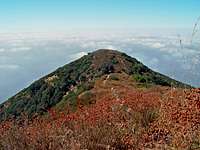
From here you will have to find your way up the southwest ridge of Mount Yale. At the beginning of the ridge there is a water tank which marks the right spot. As you continue up the ridge the chaparral gets significantly thicker and at some locations almost forces you to turn back. If you make your way through the thick buckthorn bushes, yuccas, and manzanitas, you will reach a small bump in the ridge. From here the path is straightforward and continues along the ridge over beautiful rocks to the summit of Mount Yale (~4,780'). There is some easy fun rock climbing along the way. From the water tank to the top it's about 560 elevation gain in less than 0.5 miles. From the summit the views are breathtaking all around: from northwest to southwest the impressive Eaton Canyon with Mount Lowe, Mount Markham, and San Gabriel Peak towering above; to the north you can follow the ridge towards Mount Wilson and Mount Harvard, which towers immediately across Mount Yale; to the west in the distance you can spot several peaks from the High Country, e.g. Twin Peaks, Mount Baldy; to the east/southeast lies the beautiful Little Santa Anita Canyon. The views are unobstructed. A little bit north of the summit area behind some bushes are gorgeous rock formations, which make incredible photo spots. You've hiked about 6 miles with a total of 4,900 feet elevation gain from the trailhead to get here.
Take the same way back down the southwest ridge to the Mount Wilson Toll Road. Continue up the road east along the south face of Mount Harvard until you reach the intersection with the Mount Wilson Trail (4,980') after about 1.4 miles. The road continues north another 1.2 miles to Mount Wilson. From the intersection take the Mount Wilson Trail south for about 0.6 miles. At around 4,450' you will get to an intersection of the Mount Wilson Trail with the Winter Creek Trail, which eventually leads to the Chantry Flat Fire Station in the Santa Anita Canyon. At the intersection take the Mount Wilson Trail down west to Little Santa Anita Canyon. The trail steadily descends under beautiful tree cover, passes the Orchard Camp, and reaches after about 2.5 miles the intersection with the Connector Trail (see above), which essentially concludes the loop in the Upper Little Santa Anita Canyon. From here continue down the Mount Wilson trail another 3 miles to the trailhead in Sierra Madre. During the hike, especially along the shaded canyon portions you will encounter plenty of Poison Oak on both sides of the trail.