|
|
Route |
|---|---|
|
|
40.05720°N / 107.205°W |
|
|
Mostly trail, with some easy cross country travel |
|
|
Most of a day |
|
|
Class 2 |
|
|
Approach
The trailhead is at a large meadow just south of Ripple Creek Pass. The road over Ripple Creek Pass is usually plowed around Memorial Day and stays open until around Thanksgiving, but each year is different.There are several ways to reach Ripple Creek Pass. There is a road from the south and Trappers Lake, one from the east and Yampa or Phippsburg, one from the northeast and Oak Creek, one from the north and Hayden, and one from the northeast and Pagoda (village) and Hamilton. I know only the road from Hamilton and Pagoda, but very few Coloradoans will be coming from that direction (Craig), so it seems rather pointless to describe the drive. Most people will be driving in from the Trappers Lake or Yampa areas.
Bring the White River Forest Service Map, and park at the meadow just south of Ripple Creek Pass. All roads are in good condition, and can be driven in a car, but 4wd may be needed in bad weather, or early or late season.
Route Description
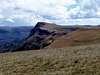
From the trailhead, follow the trail southeast. This trail is known as Trail 1803. It is an up-and-down trail, and there are several small stream crossings. The trail is very wide and easy to follow, and is well-used by horses. Eventually you will reach a large meadow. There is a trail junction here, and you also get the first views of the Lost Lakes Peaks from the meadow. The highest peak is the one on the left, and the Lost Benchmark is on the right.Turn left at the first junction. The trail to the right is labeled “Stock Drive Trail”. After a short ways you will come to another junction. Turn left here, and note the junction for the return since the sign is wrong (September 2005). The trail to the right is labeled “Picket Pen Trail”.
Not too far after this junction the trail climbs to “Lost Lakes Pass” and you can see over to the east side of the ridge. There is also a nice view of the Lost Lakes Peaks from here. The trail to the left zigzags down to the Lost Lakes, so turn right and continue along the ridge and trail. Keep left and along the ridge when you reach the next junction. The trail to the right is labeled “Trail 1812-Lost Lakes Trail”, but this is somewhat confusing because the trail doesn’t really go to Lost Lakes.
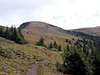
From here, the trail climbs to timberline. The trail is somewhat faded above timberline, but is still easy to follow since there are cairns and the country is open and grassy. Just stay close to the ridge.
When you are due north of the Lost Benchmark, simply hike south over the easy grassy and rocky slopes to the summit. Enjoy the excellent views from the summit.
If you want to reach the highest Lost Lakes Peak (Peak 11,935), return north to the trail and continue east on that trail. The trail is faded in places, but the route to the peak is very obvious. Make sure to stay off the ridge if there are thunderstorms present. It may be faster to head directly for the peak, rather than stay on the trail. Climbing the peak is easy, but on the summit you can climb out to the exposed northernmost point. This point looks like a savage horn from the lakes to the east.
The round trip distance to the Lost Benchmark is 13.6 miles. The round trip distance is 16 miles if you climb both peaks.