
|
|
Route |
|---|---|
|
|
37.90000°N / 107.51°W |
|
|
Mountaineering, Scrambling, Skiing |
|
|
Winter |
|
|
Half a day |
|
|
Moderate snow (up to 43°) |
|
|
I |
|
|
Approach

Great day for a snow climb!
To gain entrance to Victory Couloir, start at the American Basin trailhead at 11,300ft. An additional “upper trailhead” is also available to 4x4 vehicles and is roughly ~260ft. higher. The west face of Handies Peak when standing at this trailhead lies directly east (to the left). The western ridge of American Peak lies directly ahead and the summit is directly ahead of you. Point 13,535 and Hanson Peak lie towards the west towering above the valley.
There is a CMC summit register atop the summit in a small cairn.
Leave the trailhead and walk directly south heading up into American Basin. There is also an ATV trail that meanders up this drainage (#3314) until it reaches Sloan Lake. Stay to the left (east) of the creek and progress up towards a very prominent embankment. Once this easy embankment is crested, a shallow ravine will immediately present itself. To avoid dropping down in elevation, stay on the left and traverse keeping your elevation constant. American Peak’s true summit and its’ false summit (13,744ft.) are now quite apparent. Angle your route up towards a cut in the small but gentle ridge.
Pass through this break and Sloan Lake (12,900ft) now makes its entrance, situated a bit off to the left. Cross Sloan Lake (37º 54’ 14” N, -107º 30’ 58” W) and head directly up the southern slope. This slope will plateau out somewhat as you reach the run-out for Victory Couloir. This area (13,155ft.) is wide and open and Victory Couloir stares down at you.
One of the 'claims to fame' of this basin is the multitude of wildflowers that carpet the valley. I have never seen this valley in summer (only in spring) but the colours are amazing. It would be a wonderful place to simply camp while driving the Alpine Loop over Cinnamon and Engineer passes.
In the winter & spring, expect solitude and quiet. This wonderful place isn't visited often when snow blankets the ground.
Route Description

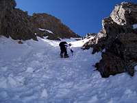
Looking down Victory Couloir.
Strap up the crampons and proceed up into the gentle but consistently steepening couloir. The pitch at the apron averages around 35º. About ¼ of the way up, the pitch steepens to 43º. You can either keep to the left or veer to the right. The cornice shown in the pictures usually forms on the right side and this rock outcropping will provide some degree of protection in the event of a break. Cornices are common on this couloir. Around halfway up the couloir, basically in between the two rock pillars, the pitch backs off slightly to around 40º. This is also where I’d recommend staying to the left as you approach the second rock pillar.
For the next ~200ft, the pitch stays somewhat constant decreasing ever so slightly until the couloir opens up and becomes quite broad towards the saddle. The saddle doesn’t sneak up on you but remains “in view” for most of the upper portion. The saddle is 13,700'. (37º 53’ 56”, -107º 30’ 38”). The finisher is a quick 0.2-mile climb across the summit ridge. The summit ridge is often corniced with heavy snow, so don’t be surprised if you have to stay just south (left) of the ridge crest until you “top out” at 13,806ft.
Essential Gear
SP Member: Shanahan96
- gaiters
- shovel
- sunscreen/hat
- probe & beacon
- poles
- regular winter clothing/gear