
|
|
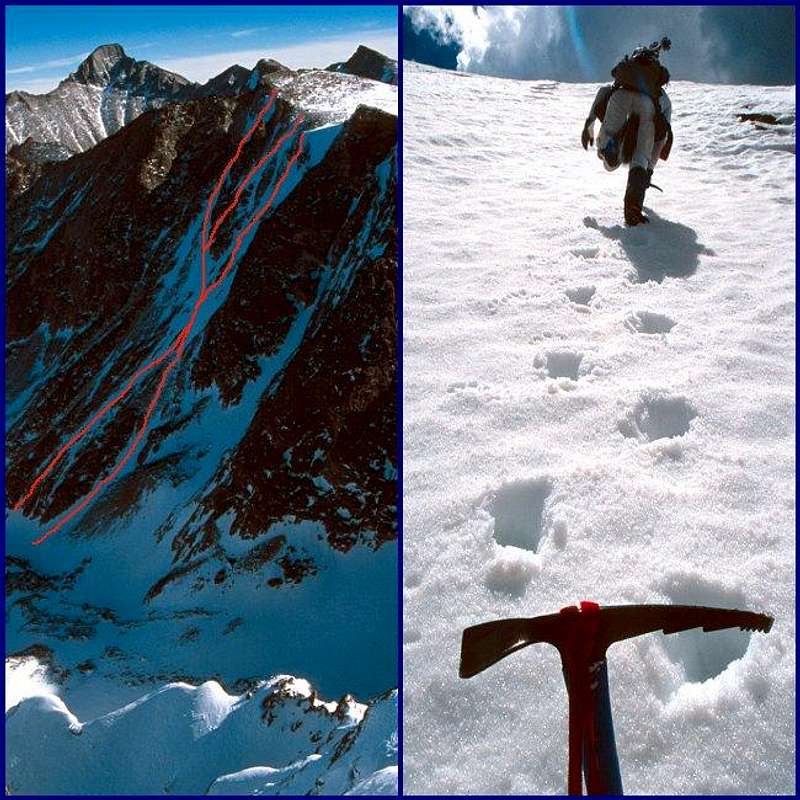
Route |
|---|---|
|
|
40.26580°N / 105.6642°W |
|
|
Alpine Snow or Ice Climb |
|
|
A long day |
|
|
Steep Snow / AI3 |
|
|
Introduction
I have wondered if Powell Peak has an inferiority complex. Nestled as it is between the stately summits of Taylor and McHenrys Peaks, it can be easily overlooked if your eye is scanning the Continental Divide from a distance.But to the climber with ice axe and crampons in hand, standing at Sky Pond and gazing at its 2,500 foot high north face, the mountain will have an instant appeal and excitement. Likewise, seeing its east face from Solitude Lake or McHenrys Notch further reveals that Powell saves its charms for those willing to exert some effort.
Approach
The climb begins at Sky Pond (10,890 feet) in the Glacier Gorge area of Rocky Mountain National Park. To reach the trailhead from the Beaver Meadows entrance turn left at the first junction on to the Bear Lake Road. Follow this road for nearly nine miles to the Glacier Gorge trailhead, at about 9,200 feet elevation. Note that as of November 2004, when construction will be complete, the new trailhead parking area will be larger, but about 1/3 mile further down the road from the old familiar, and tiny parking spot. I suspect the new lot will be just as crowded.Hike towards Alberta Falls and the lakes beyond. You will pass two main trail junctions: the first is the North Longs Peak Trail to Granite Pass, and the second is the branch to Mills and Black Lakes. Bear right at both junctions, and after 2 1/2 miles you arrive at lovely Loch Vale, with your destination in sight farther up the valley. Continue straight (left) at the Andrews Glacier junction, and you will climb out of the trees alongside Timberline Falls into the stunning cirque containing Lake of Glass and Sky Pond. It is about 5 miles from the trailhead to Sky Pond. The entire hike is one of Rocky Mountain grandeur and beauty at its best.
Shortcut: Most climbers use an unmarked trail that cuts about 20 minutes off the hike and bypasses Alberta Falls and the switchbacks above it. This cutoff begins immediately after a sizeable bridge crossing the stream, which will be about 1/2 mile from the new trailhead. This was the third bridge from the old trailhead. After crossing the bridge turn right and make your way up the slope. The path is faint at first but soon develops into a full-fledged, well-maintained trail. It joins with the main trail about 100 feet below the Mills Lake junction.
 |
Route Description
Powell Peak is on your left as you hike towards Sky Pond, and the snowfields will be obvious. It's a question of gauging conditions and choosing your line. There are a number of options and the snow often forms patterns of X's or Y's, allowing you to decide which branch to take. Early in the season take note of cornices that may overhang the route. These are usually larger on the western (right), steeper branches. The east branch reaches at least 50 degrees in slope and the western one is 60 degrees or so. The climb involves some 1,500 feet of elevation gain.Early in a typical season (May and June) you can kick steps up the snow, which progressively hardens and turns to alpine ice by August and early fall, offering a wide range of conditions to suit all skill levels.
Gerry Roach rates this as one of the *Classic* routes in Rocky Mountain National Park. I must agree. The views of the Petit Grepon and The Sharkstooth are magnificent.
Descent Options
Unless the snow is very soft this face is too steep and lacks sufficient runout for a safe glissade. This is my conservative opinion, you can decide for yourself. I have climbed the steep western branch and then downclimbed the east branch facing inward and kicking front-point steps in firm snow conditions. If your climb was on ice, then you would probably need to rap down the route.A longer alternative if the weather is holding, is to walk nearly two miles north-westward along the Continental Divide, past Taylor Peak and descend Andrews Glacier. Descents to the east into McHenrys Notch or the down Northeast Ridge are also possible, but this involves steep rock and a lot of careful routefinding.
So, in fact, Powell has nothing to feel inferior about and can provide you with an epic day!