Approach
From Oakley (State Route 32), head east along the Weber Canyon Road. After about 12 miles, turn south (right) on the Smith and Morehouse Road. Follow the good gravel road past the Smith and Morehouse Reservior. After another mile, turn right onto a road posted for Red Pine Creek. The Red Pine Creek Road deteriorates rapidly into a 4wd road. Follow the road for just over a mile and take a left at the junction. There are some very short spur tracks before this junction, so you may have to back-track short distances to find the correct road. Turn left at the junction and follow the road past a sign for the "Yellow Pine Trail". Continue on the rough road to its end. This is about 1.5 miles from the junction.
Route Description
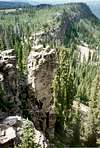
From the trailhead, follow the trails on the left (east) side of Box Canyon Creek and head south up the canyon. The trails fade shortly. Keep heading south up the canyon staying about 100 yards from the stream. There is no real trail here (despite what the maps indicate), just a cross-country route. The canyon is beautiful and pristine, and walls of cliffs line each side of the canyon. Cross-country travel is easy along this entire route and there is no bushwacking or boulder-hopping. Continue heading cross-country to the south staying on the east (left) side of the creek through some rock ribs with very visible glacial scratches on them. Walking through these rock ribs is easier than staying down by the creek. After the rock ribs are passed, the canyon opens up and there are small meadows amoung the trees. It is possible to hike on either side of the creek, but I stayed on the left (east) side. The creek cuts some interesting chutes through the bedrock in this section of the canyon. The saddle at the head of the canyon is your target and is reached by continuing along the main drainage to the gentle ridge top. The summit of Duke Mountain is reached by heading along the ridge west for about a mile to the summit. There is some very minor scrambling. The total round-trip distance is 8 miles with 2300 feet elevation gain.
![]()
Essential Gear
A good pair of boots is needed.
Miscellaneous Info
If you have information about this route that doesn't pertain to any of the other sections, please add it here.