
-
 15587 Hits
-
 76.39% Score
-
 7 Votes
|
|
Route |
|---|---|
|
|
47.99540°N / 123.4672°W |
|
|
Hiking, Scrambling |
|
|
Summer |
|
|
Half a day |
|
|
Easy hike with a short steep scramble |
|
|
Class 3 |
|
|
Overview
This route is definitely the easy way to climb Mount Angeles. For those who want spectacular views but don't feel in the mood for relentless switchbacks, this is the way to go. The difference in elevation between the parking lot and the summit is just 17 feet shy of 1000 feet. But the accumulative gain for a round-trip summit hike is closer to 2000 feet because of the ups and downs along the ridge.Getting There
Take Highway 101 to Port Angeles and then take a left on Hurricane Ridge Road to the Park entrance. Follow Hurricane Ridge Road all the way to end which is the Hurricane Ridge lookout and viewpoint parking lot.Route Description
From the parking lot, take the right fork of the Sunrise trail for less than a quarter of a mile until it intersects the Klahhane Ridge trail (well marked with signs). Follow this trail as it traverses North-East along the top of Klahhane Ridge for 2.25 miles until it crosses the Mount Angeles trail. In clear conditions, you should clearly see Mount Angeles from Klahhane Ridge.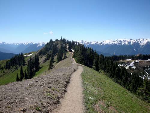
Klahhane Ridge
When you come to the Mount Angeles trail there is a small wooden post that used to have a sign that said "Mountain". Turn left here and follow the trail for another third of a mile. Don't give in to the urge to climb up the first obvious scramble that comes into view. Continue to follow the faint trail around to the west side of the summit block until it ends at the correct scramble gully.
Just below the summit it looks like there are 3 tops. The one on the right (South) is highest. Keep you eyes open for bears on the ridge. I saw one. There used to be a pesky goat that was extremely aggressive and territorial. It liked to chase people near the summit area. He chased a friend of mine up into a tree and another time he followed me and her in the dark scaring the living daylights out of us. Unfortunately tragedy struck when the goat gored a hiker in the femoral artery. The hiker died of blood loss and the goat was hunted down and destroyed.