Trip Report
Brad's Outdoor Adventures
Mount Harvard (14,420 ft) / Mount Columbia (14,073 ft)
Class 3
Distance (round-trip): 13.5 miles
elevation gain: 5,800 feet
Weather forecasts had significantly altered my plans for what would be my final mountain trip during my three year stay in Colorado. Plans finally set, I started hiking from the North Cottonwood Trailhead at two in the morning, determined to not get caught in any bad weather, as long as I could help it. By 3 a.m., a steady drizzle had wet all my clothes, but half an hour later I emerged at timberline to see the moon shining brightly and the sky clearing to the west. The air was calm, Mount Columbia was fully-illuminated by the moon, and I had Horn Fork Basin to myself... well, except for some coyotes that I heard howling near Bear Lake–always an unnerving sound when you are alone in the dark at 12,000 feet.
The trail was easy to follow by the light of my headlamp: through the trees, through the willows, up the talus, along the grassy bench, then up more rocky slopes leading to the summit. The final short scramble to the summit was surprising and fun. When I arrived at the pointy summit block (one of the best “pin-point” summits I have come across in Colorado), I was surprised to see there was still barely any light on the horizon. Looking at the time, I saw it was only 5:30!
I had not planned on watching the sunrise from Colorado’s third-highest summit, but now that I was there, why not? I huddled between two boulders just down from the summit to try to avoid the wind as much as possible. It was a very chilly hour I spent at Mount Harvard, but it was worth it for a magnificent sunrise. I was able to capture many surrounding peaks bathed in alpenglow, including Mount Yale, Mount Princeton, Mount Oxford, North Apostle, Ice Mountain, Missouri Mountain, Emerald and Iowa Peaks, and many others. To the west, the valleys were full of fog, but except for a few clouds, the skies would remain clear the rest of the day.
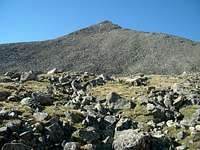
Now with real light, I was able to see the traverse ahead to Mount Columbia. It looked long as promised, so by 6:30 I was on the trail again. The first half of the traverse was easy, following a good trail which alternated between rocky slopes and a wide grassy meadow-like ridge. After this, however, my pace would slow dramatically with the rougher terrain.
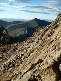
I had already decided I did not want to tackle the gnarly ridge directly, but I did want to get some scrambling in along this traverse. So, when the trail dropped down a steep, loose gully toward the rock glacier below, I followed it partway and then cut across onto the rocky east face below the traverse ridge.
I have experienced plenty of loose rock during my time in Colorado, but this was as bad as I’ve seen! The ridge may have been more difficult, but I am sure the rock would have been more solid. I followed rotten ledges up and down along the face, finding myself “cliffed out” on more than one occasion. The only solid rock seemed to be that which composed the actual cliffs; any boulder smaller than a truck seemed fit for flight. I had no choice but to take my time across all these ledges, even just for route-finding around blind corners.
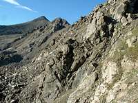
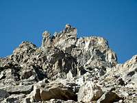
After passing below the rock formation known as “The Rabbits,” the rock became a little more stable. I continued contouring with the slopes, following ledges through cliff bands around Point 13,597 until the terrain finally relented. I found myself at the rocky fields in the upper basin below Columbia’s north-eastern slopes, and there I stopped to take a break.
Previewing my final route to the summit, I could see the difficulties of the day were behind me. Mount Columbia was nothing more than a huge pile of talus, and it would be one foot in front of the other the rest of the way to the top–great time to practice setting my pace and getting a rhythm.
I arrived at the summit of Mount Columbia at 9:30, completing the traverse from Mount Harvard in three hours. I sat at the summit for half an hour, enjoying the Colorado mountain scenery and solitude one last time before heading back east.
The descent of Mount Columbia brought back a lot of bad memories: from Mount Bross, to Challenger Point, to North Maroon Peak. It was steep, slippery, and not at all enjoyable. At least the trail was impossible to lose, and I must admit it was fun “chasing” marmots down the trail as I ran to avoid tripping over my own feet. Even with the quick pace, it seemed to take forever to reach timberline. There I met up with the first group of hikers I would see today. I would pass several others along the trail, but with the four-odd miles I had left to go, I was alone most of the time.
I ran some of the trail back to the main trail, and from there it was a pleasant, mostly flat hike the rest of the way out to the jeep. The trail paralleled the creek, which was flowing vigorously with crystal clear water, and I found my rhythm with the sound of the rush. I returned to the trailhead at 12:15, then drove in the direction of the flowing water: east.


Comments
Post a Comment