
-
 7440 Hits
-
 87.14% Score
-
 24 Votes
|
|
Mountain/Rock |
|---|---|
|
|
49.05053°N / 7.77772°E |
|
|
Hiking, Sport Climbing, Toprope, Bouldering, Scrambling |
|
|
Spring, Summer, Fall |
|
|
1552 ft / 473 m |
|
|
Overview
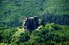
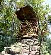
 Löwenstein Castle with climbing gear in place Löwenstein Castle with climbing gear in place |
It may seem strange to see a French climbing destination attached to the Südpfalz Group page, which is about a decidedly German region but mountains don't stop at a bordere and neither do the sandstone crags of the area. The closest spot of Fleckensteiner Felsen is located about 400m west of the French German border and nowhere on the mile long ridge is it farther than 600m apart. Moreover the regions on both sides of the border - Pfalz on the German side and Alsace on the French - in the course of history often changed ownership so that the current state of affairs confirms the area as a truly European one. The border is open and wherever you go you'll find hikers and climbers of both nationalities sharing the trails and the cliffs.
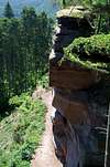
Fleckensteiner Felsen is a one mile long sandstone ridge, which runs from SW to NE between the castle ruins of Fleckenstein and Hohenbourg. On its western side the faces are short, some 20m high at best while on the eastern side you find massive and mostly vertical walls. All of these walls, even their tops, are hidden beneath the trees of the border forest so that the cliff is a perfect climbing destination on hot summer days. It was on such a day in June 2006 that we visited the area and we were astonished to find so many climbing parties along the way, even though the crags aren't really advertised anywhere. In fact the are is even more popular among hikers, mainly because of the good Alsatian food and the many castle ruins you find so very close to each other.
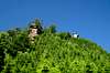
 Hohenbourg Castle
In fact you can find the ruins of four medevial castles on an area of barely 0.35 square km - all of which give testimony to the violent history of this border region. Farthest north and on German soil you find Wegelnburg castle, first mentioned in 1246. Further south, almost on the border but already on French soil there are Hohenbourg and Löwenstein, very close to each other and furthest south the largest of them all, Fleckenstein. All four castles were built in the 13th centuries but most of them were already destroyed less than 100 years later. Today only the foundations and some of the masonry are left standing, revealing the real foundation - the typical sandstone rock. And this makes all castles a very popular climbing destination as well. You will find climbing parties everywhere, often families teaching their kids how to climb.
|
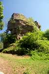
Returning to the crags - there are two which have to be mentioned particularly. Some 100m east of Löwenstein castle you can find Krappenfels, which used to be a very popular climbing destination. However, it had to be closed due to rockfall and impeding instabilities. Even more popular, at the southern end of the long Fleckensteiner Felsen Ridge, there is Fleckensteiner Turm - named after the castle some 300m beyond. This is a fine tower, the end of the ridge, which offers all kinds of routes on sometimes nicely overhanging rock. Due to its proximity to the Fleckenstein parking lot the tower is the most popular and most crowded crag of them all.
|


Climbing in the border region
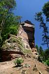
 Fleckensteiner Turm
The following information is linked from the site of the Vereinigung Pfälzer Kletterer I link to their routes database directly with some summary info. Here is the link to the complete database.
| Region | Routes link | Summary |
| Wegelnburgfels Krötenstuhl | Krötenstuhl | 4 routes 6 - 7-/ |
| Wegelnburgfels Krötenstuhl Westgipfel | Krötenstuhl Westgipfel | 3 routes ranging 2 - 5+ |
| Kaiser Wilhelm Turm | Kaiser Wilhelm Turm | 1 route rated 2 |
| Löwenstein | Löwenstein | 3 routes 5 - 8-/ |
| Krappenfels | Krappenfels | 6 routes ranging 2 - 6+ |
| Fleckensteiner Turm | Fleckensteiner Turm | 7 routes with variations ranging from 4+ - 8- |
| Fleckensteiner Felsen, Kleiner Grat | Kleiner Grat | several routes, no grades |
| Langenfels | Langenfels | 9 routes ranging 2 - 9 |
| Fleckensteiner Wand - Grande Face | Grande Face | 10 routes with variations ranging from 2 - 9- |
| Fleckensteiner Wand - Petite Face | Petite Face | 9 routes ranging from 5 - 8 |
Getting There
Though located on French soil Fleckensteiner Felsen can be reached from both sides of the border. The closest village on German ground is Hirschthal, the closest on the French side is Lembach. The following itineraries start at the nearest airports, Frankfurt, Stuttgart and Strassbourg.wwFrom Frankfurt
There are two possible routes which both take equally long- Via Ludwigshafen
- From Frankfurt take motorway A5 southward to Darmstadt.
- There change to A67 south.
- At Viernheimer Dreieck turn onto A6 west. Leav
- e it at Frankenthaler Kreuz for A61 south.
- At Mutterstädter Kreuz take A65 south until you reach Landau.
- At Kandel turn onto B427 west.
- After Busenberg turn onto L489 to Bundenthal
- At Bundenthal torn onto L478 / L488 to Schönau and Hirschthal
- Via Kaiserslautern
- From Frankfurt take motorway A3 west
- At Mönchhofdreieck turn onto A67 south
- At Rüsselsheimer Dreieck take A60 west
- At Kreuz Mainz Süd take A63 south
- At Kreuz Kaiserslautern turn onto A6 west
- At Kreuz Landstuhl turn onto A62 south
- At Pirmasens turn onto B10 east
- At Hinterweidenthal turn onto B427 south
- Behind Reichenbach turn onto L489 to Bundenthal
- At Bundenthal torn onto L478 / L488 to Schönau and Hirschthal
From Stuttgart
- Take motorway A8 to Karlsruhe
- At Karlsruher Dreieck turn north onto A5
- Take the next exit to head for A65
- At Kandel take B9 south
- At Lauterburg take D3 through Wissembourg to Lembach and Hirschthal
From Strassbourg
- Take motorway A4 north
- At the Brumath Intersection take N340to Haguenau
- There take D27 north to Lembach and Hirschthal
Red Tape
Yes, there is red tape and lots of it. The sandstone of Südpfalz forms lots of caves and overhangs. Though this makes it most interesting for climbers, two species of birds of prey compete for this habitat: the peregrine falcons and the eagle owls. Both are endangered and wherever there is a eagle owl pair found nesting in the sandstone the crag will immediately be closed. Generally this closure lasts from the beginning of each year through Aug. 1st. If breeding is not successful the closures will be cancelled even before that date. For a list of closures see the Closure List of PK.The use of magnesia is not allowed in the whole Südpfalz region. This is rather a directive or an arrangement than an outright law. Thus you probably will get away with using it but do so only when absolutely necessary. Magnesia closes the pores which you find in the sandstone and together they form a smooth surface which will get very slippery in wet conditions. The rule of thumb is to use magnesia in the highest difficulty sections and only extremely sparingly.
A list of guidelines can be found here (in German).
Accommodation and Weather
The closest town of importance is Wissembourg / Weißenburg on the French German border. Here is the tourist information link on which also the current weather info can be found:Maps & Books
Maps
As for maps there is a good overview map (1:50000) by Kompass Verlag but the best ones are the official topographic maps by the state government of Rheinland Pfalz, scaled 1:50000, 1:25000 and 1:5000. All official maps can be found on the web page of Landesvermessungsamt Rheinland Pfalz
1:50000
- Naturpark Pfälzer Wald
Kompass Map WK766
ISBN: 3-85491-523-3
- Bad Bergzabern
LVA RLP Map L6912
ISBN: 3-89637-194-0
1:25000
LVA RLP Map 6913
ISBN: 3-89637-153-3
Books
here are a number of climbing guidebooks on the region of Südpfalz. The best ones, however, have been published privately and are sold only in selected bookshops of the region.
- Hiking
- Pfälzerwald
B. & J.-Th. Titz
Rother Verlag
ISBN: 3-7633-4268-0 - Klettern im Buntsandstein
U. Daigger, H.-J. Cron
Published privately and out of print
- Pfalz ++, Klettern im Buntsandstein
R. Burkard, P. Weinrich
Published privately
- Klettern im Naturpark Pfälzerwald
Naturfreunde Lambrecht
Published privately - Pfalz & Nordvogesen en bloc
A. Wenner, Y. Corby, I. Bald
Panico Verlag
ISBN: 3-936740-19-4
Climbing
visentin - May 7, 2010 9:39 am - Voted 10/10
a french one :)thanks for the addition !