
-
 8002 Hits
-
 76.66% Score
-
 7 Votes
|
|
Custom Object |
|---|---|
|
|
Trail |
|
|
Los Angeles |
Introduction
There isn’t a specific place to post trails on the SummitPost format, so I submit this page on the Sunset Ridge Trail in the front range of Southern California’s San Gabriel Mountains as a custom object.Overview: A Trail Short and Sweet
The Sunset Ridge Trail is only about 2.5 miles in length, but affords great beauty at a very accessible range from the metropolis below. The trail starts out contouring the Sunset Ridge above Millard Canyon and, near the canyon bottom, begins an ascent to the top of Sunset Ridge and there connects with the Sunset Ridge-Mt. Lowe Fire Road. This fire road winds its way through the front range in a generally northeasterly direction for about 9 miles ending at Eaton Saddle near San Gabriel Peak. But our focus here is on the Sunset Trail.Hiking the Trail
From the fire road gate at the Sunset Ridge Trailhead above Altadena, begin hiking up the Sunset Ridge-Mt. Lowe Fire Road. Within 100 yards you will come to the point where the Altadena Crest Trail crosses the fire road. A marked sign to your left points to the ½ mile descent on the Altadena Crest Trail into Millard Campground.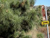 Junction with Alta Crest Trail going to Millard Campground
You will come to the start of the Sunset Ridge Trail off to your left about 400 yards further along the fire road. It is marked by a sign.
 Start of Sunset Ridge Trail off of Fire Road
 Looking up Millard Canyon from Sunset Ridge Trail
About ½ mile from the start of the trail, you will come to a junction. To your left is the creek which winds down the canyon. A popular destination following the creek upstream is Dawn Mine, where gold was once mined. The Sunset Trail, however, continues to the right (it is marked here as well), but now it begins to climb out of the canyon. In about 1 mile of ascent, you arrive at Sierra Saddle/Sierra Camp. From here, you can see the fire road just below you. There are great views looking north from this saddle.
 View North from Sierra Saddle
The destinations on the next part of the trail are posted on a wood sign.
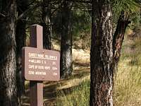 Destinations from Sierra Saddle
 Rock Outcrop at Cape of Good Hope
The trail ends after 2.5 miles total by connecting once again with the fire road.
 Sunset Ridge Trail at its terminus with fire road
Other Destinations
Up the fire road about 100 yards on your right is the beginning of the Echo Mountain Trail. Start of Echo Mountain Trail off of Fire Road
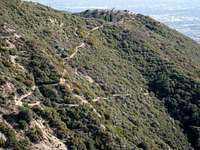 Echo Mountain seen from end of Sunset Ridge Trail
If you continue on the fire road past the Echo Mountain Trail junction, you will quickly arrive at the Cape of Good Hope. From here, you get awesome views looking down the length of Millard Canyon.
 View into Millard Canyon from Cape of Good Hope
A multitude of other trails to interesting destinations in the San Gabriel front range come off of the fire road as it winds its way to its terminus at Eaton Saddle near San Gabriel Peak. The fire road is a favorite with mountain bikers.
Final Words
The Sunset Ridge Trail up and down is a 5-mile roundtrip from the trailhead. It is a favorite running trail of mine. But hiking or running, you can’t do better than this trail when you only have a couple of hours for an outing and want a trailhead that is very close by if you live in the San Gabriel Valley.Getting There
From the 210 Freeway exit at Fair Oaks Ave. and take Fair Oaks north toward the mountains. At Loma Alta Drive, turn left and proceed about ½ mile to Chaney Trail Drive. The intersection is marked by a flashing yellow traffic signal. Turn right onto Chaney Trail Drive and ascend to Sunset ridge where you will come to a junction. Going to the left takes you down to Millard Canyon Campground. Instead, look immediately to your right and you will see a white fire road gate and some very limited parking spaces along the road in front of the gate. If there is no parking here, start back down Chaney Trail Drive and you will find lots of parking along the road.Walk to and past the fire road gate and you are on your way.
Red Tape
You will need an Adventure Pass to park your vehicle at this trailhead. There have only been rare occasions when Adventure Passes ($5 per day or $30 for a yearly pass) were sold at this trailhead. It is best to purchase one beforehand. They are sold at most sporting goods stores.No permit is required to hike the Sunset Ridge Trail nor for any of the trails that lead off of the Mt. Lowe-Sunset Ridge Fire Road.
When to Hike
The Sunset Ridge Trail can be hiked year round. Because of its low elevation, the trail normally does not get snow, even in winter. The Sunset Ridge trailhead is also accessible year round. However, be advised that access by vehicle to Chaney Trail Drive leading to the trailhead is only allowed, according to a warning sign, between the hours of 6 a.m. and 10 p.m. daily.Other Information
There are no water sources on the Sunset Trail. However, it is shaded most of its length.USGS Topos Pasadena 7.5; Mt. Wilson 7.5