Starting Point: Lehra Saddle (3650 m, 12000 ft)
Climb Kaoon Peak (4075 m, 13369 ft)
Move base camp to the banks of Sesang River (3470 m, 11385 ft)
Climb Sesang #1 Peak (4135 m, 13566 ft)
Total hiking distance: 13 Km, 8.1 miles
WEDNESDAY JUNE 14, 2006
My guide Salim and I had been very tired last night and had slept at 8:00 p.m. (in our tent at the 3650 m, 12000 ft Lehra Saddle). I woke up around 1:00 a.m. and was then just tossing and turning in my sleeping bag. I could see the moon light through the tent.
It began to lighten up at around 4:30 a.m. Salim got up after 5 a.m. to do his prayers. I had earlier obtained his permission to film him while he prayed. At that moment, however, filming him felt very awkward. In the end, I did film him for a few seconds. For his morning prayers, he puts a white shawl which has a few blue stripes on it around his neck. He also uses three cubes that have Hebrew writings on them and have long leather straps. He attaches two of the cubes to his forearms and puts the third one over his forehead (just like a headlamp) and then reads his pocket size Torah whispering it to himself.
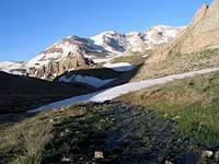
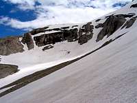
From inside the tent, we had good views of the four eastern-most Sesang Peaks (highest 4130 m, 13550 ft). We had breakfast and then packed the tent and all of our other supplies into our backpacks and left them there behind a rock. We were going to climb the Kaoon Peak (4075 m, 13369 ft) and then return to the same spot to move our camp elsewhere.
Sesang Peaks
Sub-Peak
Kaoon
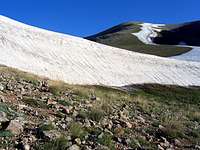
Kaoon rose directly above us to the northeast. It seemed like an easy hike over dirt slopes. At first I was mistaking the sub-peak (3956 m, 12979 ft) for the summit of Kaoon. A very long and narrow strip of snow went from where we were standing all the way to the summit of the sub-peak. Winter winds must have piled up the snow along the length of that strip. The height of the snow bank was a good 3 to 4 meters (10-13 ft).
Damavand & Lehra
Left at 7:40 a.m. and headed up the slopes of Kaoon. To the southeast, I could see the rocky and snowy northern slopes of the first Lehra Peak (3890 m, 12762 ft) which we climbed yesterday. As we went higher, I kept looking to the southeast to see if Mt Damavand (5671 m, 18606 ft) had come to view yet. It was funny how one moment I did not see it, and then two
Zebra Pattern
steps higher, the tip of it suddenly came to view. As we went higher, more of Damavand kept rising above the Lehra Peak.
To the south and the southwest, I could see the upper portions of the Sesang River Valley and the 4000 m peaks around it. The strips of snow around the valley, created a “zebra-like” pattern.
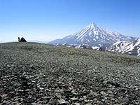
We reached the summit of Kaoon at 8:50 a.m. (1.77 Km from Lehra Saddle). The summit was a large dome-like area that was covered by crushed rock with a gray/teal color. A pile of rock erected by previous climbers marked the summit.
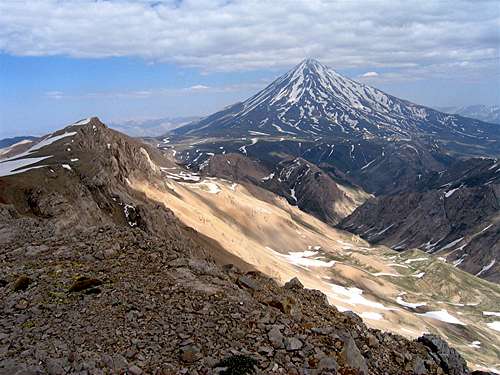
To the southeast, the sharp summit of Mt. Damavand pierced the sky. The base of the cone of Damavand is approximately 30 Km (19 miles) in diameter. Great size and height make Damavand superior to all other mountains around it.
Damavand
Takhte Khers
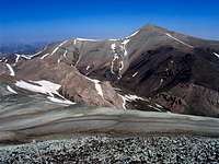
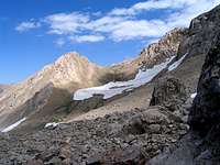
To the south, the peaks of the “Dokhaharan Massif” rose across the Sesang River Valley. Most of the peaks were situated on the crest of a 14 Km (9 mile) long ridgeline that ran east-west and was mostly above 4000 m. The ridgeline created a long and impressive wall whose northern slopes were still covered by lots of snow. Unlike Kaoon, and its nearby summits which were nothing but piles of gravel, the peaks of the ridgeline were rocky and had a pink hue. The twin summit of Dokhaharan Peak (4338 m, 14232 ft) was the highest of those peaks.
Dokhaharan, Chapakro & Erim
Sesang
Vararoo
Kholeno Massif
In the distant west (40 Km, 25 miles away) some of the 4000 m peaks of the Kholeno Massif (highest point 4387 m, 14393 ft) could be seen. Last year we had gone to climb some of those peaks but the snow-bound needles in the area proved to be very difficult for me and we were forced to abandon our plans. I hope to climb those peaks in the future via a different route.
The lone summit of Azad Kooh (4390 m, 14403 ft) rose to the northwest (48 Km, 30 miles away). “Azad Kooh” means “Free Mountain” and is so called because it is a lone peak that rises far above its neighbors. Its prominence makes it appear as a mini version of Mt. Damavand and has earned it the nickname “Shazdeh” (prince/princess). We had climbed Azad Kooh last year. Much closer across the valley, the Shekar Leghas Peak (4278 m, 14035 ft) was in good view. Like Kaoon, Shekar Leghas was a big pile of teal colored gravel. We were hoping to climb it during the next few days.
Azad Kooh
Shekar Leghas
When planning this trip months ago, I had considered heading west from the summit of Kaoon to climb its 3956 m sub-peak and two other nearby nameless peaks (3898 m & 3890 m). From the summit, I could see the two nameless peaks. They looked rocky and interesting but at that moment, spending the energy to climb nameless peaks that were lower than their neighbors seemed like a waste of effort.
Damavand
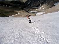
We then left the summit of Kaoon and hiked quickly down its easy slopes back to near the Lehra Pass where we had left our backpacks. The plan was to move the camp lower down the slopes to the banks of the Sesang River. Our backpacks were extremely heavy. We had supplies for 11 days (After doing an 8 day trip there, we were hoping to do a 3 day trip in the Veravasht Peak area). We had to sit down to put the backpack on and then have our partner help us to get up.
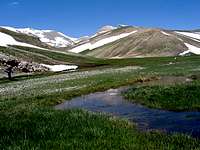
Left at 10:00 a.m. and started to slowly go down the slopes. Damavand came to view in some places. We actually veered west and went over a saddle north of Point 3662 m until we reached another drainage that seemed to go down to the Sesang River. From up the drainage, we saw a fairly large flat grassy area at the junction of the Sesang River and a side stream that we felt was the perfect spot for our camp.
Perfect camping spot
Sesang River
Where we camped
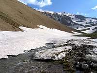
Continued down the drainage until we reached the Sesang River (3470 m, 11385 ft). The river was too deep for us to cross. We walked upstream a little until we reached the grassy area where the river split into smaller streams that were wide and shallow. Salim took his boots off and walked in the water barefoot. I thought I could get away with not doing that but much water went into my boots. That could have been a disaster but fortunately we were close to where we wanted to set our camp.
Where we camped
We actually moved away from the Sesang River a little and chose a spot for our camp on the banks of a smaller stream that drained the valley between the Chapakro and Sesang # 1 Peaks. I was very happy thinking that we had found a beautiful area to camp. It was odd how the grass only covered the flat area and ended very abruptly where the mountain slopes began. It almost looked like a man-made lawn: short grass, no weeds…
Where we camped
It was 11:00 a.m. (1.5 Km from Lehra Pass). I took my boots and socks off and walked barefoot over the grass. We set our tent and had lunch, then spread our mattresses over the grass and took a nap in that relaxing environment. The wind was cold but I put on my jacket and the sun warmed me up pretty nicely.
Got up after a 40 minute nap, there was still a lot of time left in the day so we decided to Climb Sesang #1 Peak. “Sesang” refers to a series of five peaks on the crest of a ridgeline that rose directly to the south of us. West to east, these include:
Sesang #1, 4135 m (13566 ft)
Sesang #2, 4130 m (13550 ft)
Sesang #3, 4050 m (13287 ft)
Sesang #4, 4089 m (13425 ft)
Sesang #5, 4050 m (13287 ft)
We had seen these peaks yesterday and earlier today (Click here for a view from the top of Kaoon Peak). It had appeared that some of the peaks were rocky and probably hard to approach but #1, which was the highest one of them, would present us with nothing more than steep snow slopes. From our camp, we could only see #1 & #2.
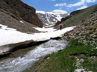
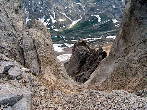
Narrows
Narrows
My boots had become dry enough to wear again. I put on a new pair of socks and hung the wet ones from the tent to dry.
Left our camp at 12:40 p.m. and followed the stream south toward Sesang #1. We soon reached a narrow rocky area. The stream kept disappearing under big snow banks and then appearing again.
Narrows
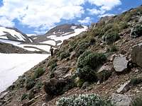
Beyond the narrows, the area opened up and we began to go up in elevation slowly. The “lawn-like” grass was gone but the slopes were covered by either snow or scattered green grass with tiny yellow flowers and other thorny plants.
Erim 4160 m
Point 4020 m
I kept looking to the southwest to see the Chapakro Peak (4260 m, 13976 ft) which we hoped to climb the next day. I kept seeing peaks that I thought were Chapakro but as we went higher, higher peaks kept appearing behind them. It wasn’t until much higher that I came to realize that there were really 4 peaks in that area. These were Point 3768 m, Point 4020 m, Erim 4160 m & Chapakro 4260 m. My map seemed to confirm that too.
Erim 4160 m, Point 4020 m & Point 3768 m
Point 4090 m
The stream that we were following would have eventually led us to a 3990 m (13090 ft) saddle between Chapakro & Sesang #1. We decided to not go to the saddle so we crossed to the east side of the stream and began to hike directly up the slopes of Sesang #1. For quite some time we were mistakenly thinking of a 4090 m (13419 ft) point to the east of Sesang #1 as the summit and kept hiking toward it.
Point 4090 m
Point 4090 m
We could then see some of the rocky wall-like areas on the slopes of Sesang #2. These areas gave rise to a fairly prominent 3870 m (12700 ft) sub-peak that sat on the slopes of #2.
Point 3870 m
To the north we came to see the southern slopes of the 4075 m (13369 ft) Kaoon Peak which we had climbed earlier in the day. Its 3956 m (12979 ft) sub-peak could also be seen. These slopes only had a few narrow but very long snow streaks. The teal/gray color of the gravel on those peaks was quite striking.
Kaoon
Chapakro (Conehead)
Summit from Point 4090 m
As we went higher, the real Chapakro Peak finally came to view. From that angle, it looked like a cone with a rounded head, very different than what we had seen of it yesterday and earlier today. I knew that Chapakro was also known as Makhroot Sar (means Cone Head). The reason for that name had finally become apparent.
We kept going up snow covered slopes toward Point 4090 m until just below it, the real summit of Sesang #1 appeared. Fortunately, it seemed that reaching the real summit only required a hike over more snowy slopes. It had by that time become partly to mostly cloudy.
Southwest
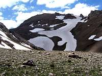
We reached the summit at 3:15 p.m. (4.1 Km. 2.55 miles from our camp). The view to the south suddenly appeared. Right below us to the south, rocky walls seemed to drop down to the bottom of the Deev Asiyab River Valley (3350 m, 11000 ft) which seemed to be covered with green grass, white patches of snow and at least a couple of small turquoise lakes.
South Wall
To the south and the southwest, I could identify many peaks that were mostly in the 3700-3900 m range (12ers ft). A very small portion of the Lar Reservoir could also be seen.
Deev Asiyab Valley & Lar Resrvoir
Ghareh Dagh & Gaving Chal
In the distant southeast, the western portion of the peaks of the Ghareh Dagh Ridgeline (highest point 4072 m, 13360 ft) was visible. The eastern part of the ridgeline disappeared behind Mt. Damavand. The huge cone of Mt. Damavand (5671 m, 18606 ft), was of the course the absolute king to the east/southeast. Sesang #2 (4130 m, 13550 ft) stood in front of Damavand. We could have probably hiked to the summit of #2 very easily but it was late in the day.
Damavand, Sesang #2 & Deev Asiyab Valley
Dokhaharan & Chapakro
Chapakro & Erim
To the west, the twin summits of the Dokhaharan Peaks (4338 m, 14232 ft), Chapakro (4260 m, 13976 ft) & Erim (4160 m, 13648 ft) were in good view. I could not see any easy route to reach the summit of Chapakro but knew that the west side of it (that we could not see from there) supposedly provided access.
To the north, the Shekar Leghas (4278 m, 14035 ft) & Kaoon Peaks (4075 m, 13369 ft) appeared as huge piles of gray/teal colored gravel. Some of their lower slopes were brown/maroon colored. They only had a few long and narrow snow patches on them.
Kaoon
Shekar Leghas
Hiking Down
We left at 3:50 p.m. and began to hike down the snowy slopes back to our camp. We were actually able to hike on snow all the way back to near the narrows. That made our descent very quick and easy. In the narrows, we reached an area where we had to go up a wall of snow 10 ft tall, ended up using the ice axe there.
Looking Back
Reached our camp at 5:30 p.m. Salim began to cook and I sat outside to write my diary but it became very cold. We then had dinner and went to sleep as soon as it became dark. We had hiked a total of 13 Km, 8.1 miles.
The most dramatic animals are bears, wolves and wild boars (I have seen boars but not bears). You will of course find different species of deer/wild goat...
I have also heard of Asiatic Cheetahs and hyenas. Cheetahs are now very much endangered and are limited to the remote parts of the desert. I don't know if they ever inhabited these mountains to begin with or not.
I knew that the cheetah evolved in North America and crossed over the Asian/North American landbridge long ago, but I didn't realize any were remaining anywhere but Africa! Thanks for the information!
Yep. Evolved here in North America. Lots of fossil cheetahs found here. It's closest living relative is the Mountain lion (AKA cougar--Felis concolor). Both cats have smallish heads for large cats.
jfrishmanIII - Mar 15, 2007 4:20 am - Hasn't voted
Re: Asiatic cheetah??!!
In India they used to hunt with trained cheetahs, right up until the end of the Raj. They'd take them out on bullock carts wearing hoods like falcons. When they found game the hoods came off and the cats would launch after gazelles or whatever game was on the menu. I've seen old footage from the '40s: amazing!
Parents refers to a larger category under which an object falls. For example, theAconcagua mountain page has the 'Aconcagua Group' and the 'Seven Summits' asparents and is a parent itself to many routes, photos, and Trip Reports.


Comments
Post a Comment