
-
 5602 Hits
-
 85.17% Score
-
 20 Votes
|
|
Mountain/Rock |
|---|---|
|
|
49.20974°N / 7.85923°E |
|
|
Hiking, Sport Climbing, Toprope, Scrambling |
|
|
Spring, Summer, Fall, Winter |
|
|
984 ft / 300 m |
|
|
Overview
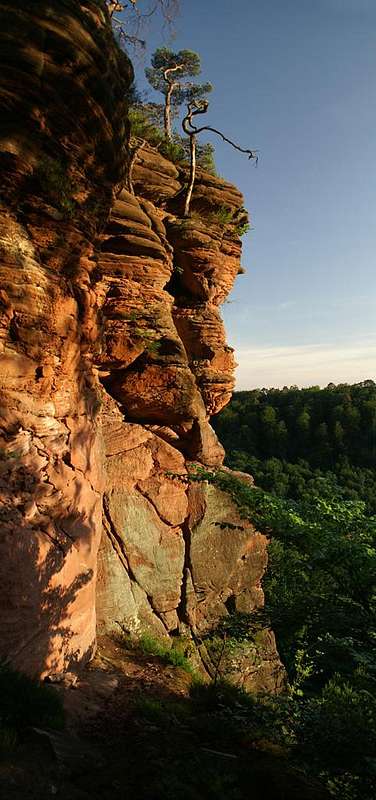
 Eastern Tower Eastern Tower |
Here is a little gem from the Südpfalz Climbing Region, a climbing cliff, which might not be one of the highest or most impressive, which certainly is not one of the most popular cliffs either, but which offers short access and lots of interesting routes of all grades of difficulty. The crag, Mittlere Deichenwand, is located directly above one of the two sports field of the village of Willgartswiesen, which serves as starting point for quite a number of sandstone cliffs, which lie strewn around the beutiful little valley in which it lies.
The name "Mittlere Deichenwand" already indicates that there are more rocks of the kind in the immediate vicinity, a "Vordere Deichenwand" and a "Hintere Deichenwand" (front, middle, back), but arguably the middle one which this page is about is the most interesting one. It is formed like an amphitheater, or if you prefer it, like a building with two protruding wings. The wings in this case are two towers to the west and east of the crag, the eastern one of which has a vertical face, dropping right to the bottom of the valley, while the western one ends some way mid-slope of the Vorixel Mountain, out of which it protrudes. In between the towers there is a sloped and curved wall, the slabs of which offer some reall interesting and somewhat difficult climbs. All three features are topped by short overhangs, above which grows the usual (typical) mixture of bushes and little pine trees.
Access to the crag is easy, hough you have to make sure you find the correct path among the many which start from the parking lot near the sports field. Right beneath the crag a kind of mini-ferrata has been built to guide climbers and would-be climbers to the starting points of the faces without the danger of damaging the soft and fragile soil beneath the crag. Mittlere Deichenwand, as well as its neighbours are part of a nature preserve, which encompasses the whole valley and surrounding mountains up to their ridges, which is called "Naturschutzgebiet Tiergartenhalde".
Maybe one comment about the surrounding cliffs: right across the valley are the remains of the old Falkenburg castle, which nowadays is not much more than just another climbing cliff with several features which remind you of its past. On the same side there are the two other Deichenwand crags as well as Eselsturm, while in the middle distance you can see Bavariafels and Spirkelbacher Rauhfels. Right on top of the crag a little wooden lookout platform has been built, more to take in the views down the walls of the crag itself than to look towards the crags of the vicinity.
 |
 |
 |
 |
 |
Climbing Mittlere Deichenwand
 Eastern Tower
Rather than reprinting the copyrighted information from the site of the Vereinigung Pfälzer Kletterer I link to their routes database directly with some summary info. Here is the link to the complete database.
| Feature | Routes link | Summary |
| Mittlere Deichenwand | Mittlere Deichenwand | 22 routes with variations ranging from 2 - 8- |
Getting There
 Mittlere Deichenwand
Mittlere Deichenwand is located at the western end of the village of Wilgartswiesen, right above one of the sports fields. The closest airports are at Frankfurt and Stuttgart so the itineraries start there too.
From Frankfurt
There are two possible routes which both take equally long- Via Ludwigshafen
- From Frankfurt take motorway A5 southward to Darmstadt.
- There change to A67 south.
- At Viernheimer Dreieck turn onto A6 west. Leav
- e it at Frankenthaler Kreuz for A61 south.
- At Mutterstädter Kreuz take A65 south until you reach Landau.
- At Landau turn on B10 west.
- Leave B10 at Wilgartswiesen, drive through the village and right at its end turn right into the street which leads to the sports field. There is a convention hall with ample parking space.
- Via Kaiserslautern
- From Frankfurt take motorway A3 west
- At Mönchhofdreieck turn onto A67 south
- At Rüsselsheimer Dreieck take A60 west
- At Kreuz Mainz Süd take A63 south
- At Kreuz Kaiserslautern turn onto A6 west
- At Kreuz Landstuhl turn onto A62 south
- At Pirmasens turn onto B10 east
- At Wilgartswiesen turn off and follow the instructions above
From Stuttgart
- Take motorway A8 to Karlsruhe
- At Karlsruher Dreieck turn north onto A5
- Tke the next exit to head for A65
- At Landau North turn to B10
- Rest as above
 |
 |
 |
 |
 |
Red Tape
 Vanessa cardui
Mittlere Deichenwand is located in the natural preserve "Naturschutzgebiet Tiergartenhalde". The usual restrictions apply. Moreover there are rules which apply for all crags of the Wasgau region:
The sandstone of Südpfalz forms lots of caves and overhangs. Though this makes it most interesting for climbers, two species of birds of prey compete for this habitat: the peregrine falcons (see section above) and the eagle owls. Both are endangered and wherever there is a eagle owl or peregrine falcon pair found nesting in the sandstone the crag will immediately be closed. Generally this closure lasts from the beginning of each year through Aug. 1st. If breeding is not successful the closures will be cancelled even before that date. For a list of closures see the Closure List of PK. However, if you find "Stop" signs on the access routes to the crags, please don't go there!
The use of magnesia is not allowed in the whole Südpfalz region. This is rather a directive or an arrangement than an outright law. Thus you probably will get away with using it but do so only when absolutely necessary. Magnesia closes the pores which you find in the sandstone and together they form a smooth surface which will get very slippery in wet conditions. The rule of thumb is to use magnesia in the highest difficulty sections and only extremely sparingly.
A list of guidelines can be found here (in German).
Accommodation
You can find hotels and apartments in Rinnthal or Wilgartswiesen. Have a look at the following links (which are in German, however):Weather Conditions
The following link is for the village of Wilgartswiesen:Maps & Books
Maps
As for maps there is a good overview map (1:50000) by Kompass Verlag but the best ones are the official topographic maps by the state government of Rheinland Pfalz, scaled 1:50000, 1:25000 and 1:5000. All official maps can be found on the web page of Landesvermessungsamt Rheinland Pfalz
1:50000
- Naturpark Pfälzer Wald
Kompass Map WK766
ISBN: 3-85491-523-3
- Pirmasens Süd
LVA RLP Map L6910
ISBN: 3-89637-193-2
1:25000
Books
Here are a number of climbing guidebooks on the region of Südpfalz. The best one is the one by U. Daigger and H.-J. Cron, complete with many topos. However, it is hard to get by and often out of print almost immediately after a new edition has been published. Currently it is available here.
- Hiking
- Pfälzerwald
B. & J.-Th. Titz
Rother Verlag
ISBN: 3-7633-4268-0 - Klettern im Buntsandstein
U. Daigger, H.-J. Cron
Westpfälzische Verlagsdruckerei St. Ingbert
ISBN: 3-00-015457-4
- Pfalz ++, Klettern im Buntsandstein
R. Burkard, P. Weinrich
Published privately
- Klettern im Naturpark Pfälzerwald
Naturfreunde Lambrecht
Published privately - Pfalz & Nordvogesen en bloc
A. Wenner, Y. Corby, I. Bald
Panico Verlag
ISBN: 3-936740-19-4
Climbing