Hike to Dripping Spring Mountain

Hike to Dripping Spring Mountain

Page Type Page Type: Trip Report
Location Lat/Lon: 35.61900°N / 83.599°W
Date Date Climbed/Hiked: Nov 16, 2007
Activities Activities: Hiking
Seasons Season: Spring, Summer, Fall, Winter

Hike to bag Dripping Spring Mountain, Great Smoky Mountains National Park

When my family and I got ready for our last vacation of 2007, I thought
Storm hits at Newfound Gap.Storm hits.
that I would have the opportunity to bushwhack to the summit of Mount Mingus and finally bag that peak. However, the day we arrived in the park, November 14, we found ourselves in the midst of a major winter storm. I had not come prepared for hiking on ice, which was coating the ground, along with heavy snow. Driving up to Newfound Gap, from which I had hoped to hike to Mingus, we found ourselves in driving snow, high winds, icy surfaces, and very cold conditions. In addition, not long after we got to Newfound Gap, the Park Service chose to close 441 so that my family could not drive back up to get me even if I had been prepared for hiking on ice. So I made the decision to head back down to our campsite at Elkmont Campground.
We wait.Stuck in the storm.

Not long after leaving the gap, we found ourselves stuck in a line of traffic while the Park Service blocked the road so that they could turn back everyone who had been heading up the mountain from Gatlinburg. This took well over two hours, but we didn’t complain, as it gave us time to sit and enjoy the snowstorm and the piling white. When the signal was given to proceed, we just put the truck into four-wheel drive and headed back to our travel trailer at Elkmont.


With the day shot, (it was dark by the time we got back to Elkmont), I took out my topo map to figure out which peak I would bag for this last trip of the season. Since the trailheads to the higher peaks via 441 were off limits (the road was closed for the next 48 hours), I looked to see what I could bag from the Elkmont Campground. Soon, I realized the best mountain to hit would be Dripping Spring Mountain, a 4801-foot summit just to the west of the spine of the Great Smoky Mountains. It looked to me to be a good candidate for some nice views of the peaks in that section of the park, providing there was some open ground near the summit.

The storm that had closed the road and covered the high country with ice and snow was relatively short-lived, and by morning the skies were clear, even if the roads were closed. I’d promised my wife to drive her to Pigeon Forge that day, so a long hike was out of the question. But I gathered my day-hiking gear and got it ready for a Saturday hike. In the meantime, we drove into Gatlinburg and Pigeon Forge and came back to the park for some easy hikes near Elkmont (including Laurel Falls). Early the following morning I was chomping at the bit to bag Dripping Spring Mountain.

The route I chose was to take the Jakes Creek Trail to Jakes Gap and then
Trail intersection.Trail intersection.
the Lyn Camp Prong Trail toward the AT, but stopping short of the AT to bag Dripping Spring Mountain for a round trip of about ten miles and a total elevation gain of roughly 3,000 feet.

At the start, the trail is a very wide and well-maintained roadbed. It appears that the Park Service must still use this as a road for jeeps from time to time. It remains a very wide, groomed gravel road until you reach a point where you have to ford Jakes Creek via a classic Smokies footbridge. Along the way, one passes a number of small waterfalls, including one that has a tremendously fine swimming hole that I have to be sure to use when the weather is warm.
Waterfall and pool.Swimming hole.


The trail tackles the mountain at a fairly steady but easy grade. One can glimpse both Blanket Mountain on the right and the back of Dripping Spring Mountain on the left as you ascend. The forest here are classic cove hardwoods, and the hemlocks are pretty much completely dead, so what few evergreens one encounters are mainly pines. Backcountry campsite #27 is along the trail and seems to be a good place to set up a tent. Wide and spacious with a big climbing rock, fire ring, and bear cables.


At Jakes Gap I took the left-hand trail toward Dripping Spring Mountain and continued to head up, knowing that I had the lion’s share of the climb behind me. From here, I only had about eight hundred vertical feet to the summit, and less than two miles to go. The forest type changes a bit here and has a large hemlock component, although that’s moot at this point, as they’re all dead or breathing their last. The forest is going to be very open and sunny in the coming years as all of these grand old trees die off and fall over. It’s the chestnut blight all over again, it seems.

Manway to summit.Manway to summit.
By noon I found myself very near the summit of the mountain. The trail is obviously a popular one, linking up with the AT as it does, and shows the effects of heavy use by both hikers and horseback riders. Just as I was getting ready to take a look at my map and get a GPS reading, I came out of the forest onto a very open area of stunted trees and low-growing rhododendron. The views toward the spine of the park and Thunderhead were spectacular. I could also see the true summit and a manway leading in that direction, so I followed it up. Just about twenty or so vertical feet shy of the mountaintop, the manway vanishes and you have to bushwhack through some very thick rhododendron to get to the very top. If you choose to do this, it’s best to leave your pack and pick your way carefully through the hell to the true summit, from which there really aren’t any views.

After bagging the summit, I sat down in a small grassy area to enjoy the views and eat a small lunch of crackers and water. I just took it easy, snapped a lot of photos, and relaxed as I took in the scenery from a true grandstand of the Great Smoky Mountains.
Summit area of Dripping Spring MountainView from summit area.
By 12:30 or so I was ready to head back down to my family, backtracking along the same route I’d taken to the top and making it back to Elkmont at around 2:15.


Comments

Post a Comment
Viewing: 1-5 of 5
Arthur Digbee

Arthur Digbee - Nov 20, 2007 8:46 pm - Voted 10/10

ouch times two

"I’d promised my wife to drive her to Pigeon Forge that day, so a long hike was out of the question."

Both halves of that sentence hurt. :)

Been there, done that.

BobSmith

BobSmith - Nov 20, 2007 9:21 pm - Hasn't voted

Re: ouch times two

The worst of it is that I loathe Pigeon Forge. In the worst possible way. And I can only barely tolerate Gatlinburg anymore.

Arthur Digbee

Arthur Digbee - Nov 20, 2007 9:28 pm - Voted 10/10

Pigeon Forge

I agree wholeheartedly, it's awful. Plus (sad fact) the #1 reason for visiting Sevier County is now "shopping."

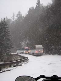
Sounds like we just missed the big storm when we left the previous Sunday.

Arthur Digbee

Arthur Digbee - Apr 22, 2010 9:48 am - Voted 10/10
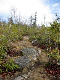
the manway

I took the manway two weeks ago, and it rapidly becomes seriously overgrown. Progress through the rhododendrons often requires taking the packs off and squeezing sideways, or over/below branches, as we moved along the summit ridge.

If you return, I'd recommend the easier bushwhack on the AT side of the rhododendron forest. When you see light from the trail, charge off up the hill.

BobSmith

BobSmith - Apr 22, 2010 8:12 pm - Hasn't voted

Re: the manway

Sounds like good advice.

Viewing: 1-5 of 5


Parents 

Parents

Parents refers to a larger category under which an object falls. For example, theAconcagua mountain page has the 'Aconcagua Group' and the 'Seven Summits' asparents and is a parent itself to many routes, photos, and Trip Reports.