
|
|
Mountain/Rock |
|---|---|
|
|
34.78790°N / 80.28600°E |
|
|
Mountaineering |
|
|
21490 ft / 6550 m |
|
|
Overview
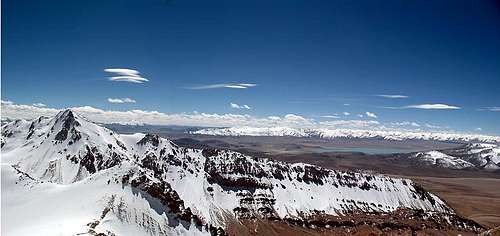
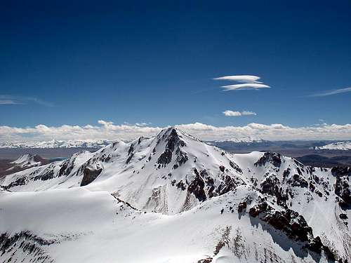 Looking at Sirengou II from 6300m on Sirengou I
When traveling the Xinjiang Highway (which connects Kashgar in Western China, with Lhasa the provincial capital of Xizang/Tibet) there are many stunning views along the way. In my opinion few are as impressive as the one of the Sirengou peaks. The group consists of three main peaks, all have the shape of long W - E ridges. Seeing the rugged, jagged and many kilometers long ridges, with a bright blue lake in front is a sight hard to forget.
The name
The range is called Dong Luokezong Shan on a Chinese military map, but the locals call the peaks Sirengou, which translated word by word means dead-man-canal. The area is at a high altitude and in both directions the road goes over passes up to 5400m. The village of Sirengou is located on an altitude of almost 5200m and is one of the highest permanent settlements in the world. The air is thin and everyone traveling through is affected by the lack of oxygen. Even the people which live there are living a life of hardship. Fatal altitude related incidents have occurred here, therefore "dead man". The last part of the name comes from the spring that feeds the lake. Everything here is called Sirengou. The village, the lake and the peaks. They don't have separate names and therefore I call them Sirengou I, II and III.
The Sirengou peaks
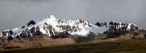
All the peaks are to my best knowledge unclimbed. The highest of them is Sirengou I, the most northernmost mountain. That's the only of the three I attempted and this page will mostly be about it. Sirengou II may look the most impressive. A long jagged ridge leads to a sharp pointed pyramid, only to drop back into the shape of a ridge again. It's about 6370m. Sirengou III is in the south and isn't that impressive. My opinion is it can be climbed quite easily, but the rock may be rotten. It's close to 6100m.
The main peak's appearance
The main peak, Sirengou I has a massive bulk. Glaciers in the NW and it's usually snow clad all along the northern flanks. The west side is a mess of snow, glaciers and ridges which looks ok from a distance, but there are many steps on rotten rock and in between glacier prone snowfields.
The southern side is filled of steep rock ridges and snowfields. The ridge gets thinner the further east you go and in the end of it's only consist of a long vertical rock face. It's not even certain where the highest point is. It's either the pyramid like summit in the west or a far away high point where Sirengou is one massive wall.
 The full length of SI seen from south
The highest point/true summit?
The official location of the highest point is at:
34°47'14"
80°17'21"
The point that looks highest when in the area:
34°47'22.41"N
80°17'9.68"E
Google Earth HP:
34°47'39.72"N
80°18'18.62"E
The three peaks
 Sirengou I Sirengou I |  Sirengou II Sirengou II |  Sirengou III Sirengou III |
Getting There
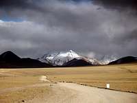 The "highway".
Whichever way you choose, it's a very long journey to get to Sirengou. When you reach the place where you leave the highway access is short and easy though.
From Xinjiang - Kashi/Kashgar
Kashgar is an oasis town on the brink of The Taklamakan Desert. It has always been a transport hub and it's the last place where you can find flights and railway transport to.
From here there are basically two alternatives:
1. With a group in a rented (it comes with a driver in China, as foreigners aren't allowed to drive on their own) vehicle, usually a Landcruiser. Travel agents in Kashgar can arrange travel permits, a vehicle, a guide and everything else you may want or need.
2. Using local transport or hitching.
Take a bus to Yecheng/Kargalik. It's about 4 hours on good road and the cost is about $5-6.
Get a local bus to the little junction settlement of Aba. About 10-15min/$0.6-0.8
The bus station for transport towards Sirengou is located about 1km from the turnoff from the main road, on the left hand side of the main road leading towards your destination. The bus you have to take is heading for Ali/Shiquanhe, which is (at least!) a 30h ride from Aba. Ask for a ticket to Sirengou. It should be about $70-80. Count on at least a 24h journey. Sirengou is a small settlement at a lake. It consists of about ten ramshackle "buildings". You can eat simple meals, stay the night in extremely basic dorms ($1.2-2) and buy soft drinks, bisquits and noodles. Don't expect much of this place.
Hitching can be a bit tricky and the situation changes all the time. Sometimes foreigners are allowed to hitch, at others the truck drivers are told by the police they can't pick up hitchers. If you're lucky you can get rides for free, but most of the time you have to expect as much as the bus ticket costs. Bargain hard and ask different truck drivers before accepting a ride.
From Xizang/Tibet - Ali/Shiquanhe
First, getting to Ali is a long way from everything, about 1300km from Lhatse in central Tibet and about 1750km from Lhasa. Most travelers arrive in Ali by pre-arranged Landcruiser or by bus from Lhasa or Lhatse.
From Ali the alternatives are the same as from Xinjiang province. Arrange a Landcruiser, go by bus or hitch. Hitching is much easier from this direction to Sirengou than from the other side as there are no checkpoints and the truck drivers pick up hitchers much more often. The bus is about $20-25/7-10h.
Altitude warning!
 Sirengou II from 6300m
If you arrive from Ali, you can skip this section.
Leaving from the lowlands of Xinjiang at roughly 1500m above sea level, straight up to the high passes over the Kunlun can be extremely dangerous. First you cross two passes at about 5000m, then you drop a bit, but after that you're firmly on altitudes over 5000m. For an unacclimatized person this can be fatal. Best option is to get some acclimatization before departing from Kashgar. One good way is to spend some time trekking in the beautiful area around Muztagh Ata, which is located some hours away from Kashgar. Take this warning seriously!
Travelers have had to turn back to the lowlands, badly suffering from AMS and worse - some have even died on the journey towards Ali.
Bad weather photos
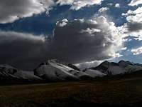 The fist The fist |  A storm rolling in A storm rolling in |  Storm warning Storm warning |
Red tape
A valid visa for China is easy to get from any Chinese embassy. The exception is the one in Bishkek, Kyrgyzstan, where you need a letter of recommendation and it'll take up to 10 days to process the application. Better get it elsewhere. If you plan to stay for a long time in China, Hong Kong is by far the best place for visas, where you can pick up a 6 month visa in 3-4hours. One place amongst hundreds of others is Cosmic Guest House, Mirador Mansions, Nathan Road. For US citizens the Hong Kong option doesn't work.Chinese embassies.
The peak fee for Sirengou is 700$ and the permit can be picked up at even the Chinese Mountaineering Association HQ in Kashgar or Lhasa. It's valid for a group up to 12 persons.
Camping & accommodation
 View from 6000m
Camping.
You can camp everywhere in the area. Officially it's forbidden to camp in China, but no one cares. I have had many visits at my camp spots by both the police and the military and they have only been friendly and curious.
Accommodation.
The only place close to the peak is Sirengou village, a little truck stop with about ten shacks. A bed in a very basic dorm starts at ($1.2-2). It's a roof over your head, a bed and in some places a thermos of hot water included in the price. These places also have a restaurant part where you can eat cheap by western standards, but horrendously expensive by Chinese. Expect to pay about Y15-25/dish, which at the time writing is about $2- 3.5.
Sirengou (village) is about 5km from the foot of Sirengou I.
When to climb
The area is of a very high altitude. All the surrounding areas are over 5000m and the Aksai Chin area is infamous for being a cold place. It's a place where a sudden blizzard can hit any time of the year and winter temperatures can drop below -40C. Therefore it's a good idea to attempt the peak in the warmest possible season. June to August is the summer months in the area. The nights can be very chilly even then and expect minus degrees on the summit. The unfiltered sun of high altitude can on the other hand almost fry you on a hot day. Be prepared for daily temperature amplitudes of at least 40 degrees even in the summer months.Mountain conditions
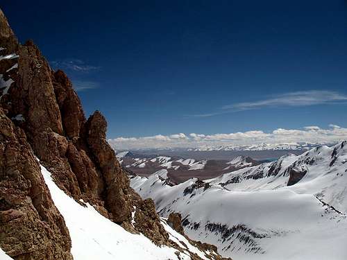 Rock towers on 6300m
It's a dry area, but if it snows here it's usually coming as a blizzard. Really fierce winds are common. The weather can change very quickly and when it changes it doesn't get bad, it gets really miserable. The north side is glaciated and in many parts steep and crevassed. The risk of avalanches has to be taken into account. The west side is a maze of rock and steep gullies and a steep avalanche prone face in the middle with steep direct access to the summit area. The southern approaches are steep rock bastions divided by equally steep couloirs which takes you you to the summit ridge. Further west on this side it's a long almost vertical rock face which looks like a real challenge for any mountaineer. I have not seen the eastern side of the peak. The bottom line is the peak is complex and route finding is hard. Rock falls are very common in the gullies on the south side.
Preparation
MoneyBefore leaving any of the larger cities get as much cash in Renminbi/Chinese Yuan as you think you'll need. There are very few places in Xizang/Tibet and in the outback of Xinjiang which changes money and it's very far in between the ATMs.
Provisions
Buy anything you need before leaving the main cities. There are plenty of great supermarkets as well as smaller corner shops in China. You can find anything you can possibly need there. When you're on the Xinjiang Highway you're usually down to the choice of noodles, bisquits, soft drinks, powdered milk and candy.
Books & maps
BooksThere's no mountain litterature about the place. If you need a guidebook for general knowledge about traveling in the area, Trailblazer's Tibet Overland is one of the better. Forget about oh so famous Lonely Planet for this area. It's crap.

You'll see quite a lot of wildlife along the way, especially if you're hitching, and then it can be interesting to know what you see. A good book about the larger mammals in the area is George Schaller's Wildlife of the Tibetan steppe.

Maps
No mountaineering map of the area exists. The closest to a detailed map you'll get is either the Russian or American air force charts.
Maptown sells the American ONC and TPC. The Russian equivalents are more detailed and have more contour lines, but are harder to find. Omnimap has them all, but it's hard to buy separate sheets and I doubt you want to buy a set of 1643 sheets for $13072 :-). Please let me know if separate sheets are available somewhere on the www.
The overview maps of Tibet/Xizang and Xinjiang are usually horrible and full of errors. Some of the better is published by Gizi and Gecko, but be aware of that for example Sirengou isn't on it. Ok for planning, but not more. Gizi Xinjiang and Gecko Xizang/Tibet