-
 5233 Hits
-
 77.36% Score
-
 8 Votes
|
|
Route |
|---|---|
|
|
36.38370°N / 117.2285°W |
|
|
Hiking |
|
|
Spring, Summer, Fall, Winter |
|
|
Most of a day |
|
|
Class 1 |
|
|
Getting There


If you are approaching Pinto Peak from the west on Hwy 190 or Hwy 178, you will be in the National Park but you won’t have to pay the $20 (as of 2008) entry fee to enter the National Park. The first pay station is located east of here in Stovepipe Wells.
There is room to pull off the road at Emigrant Pass for a few cars on both sides of the road. I car camped at Emigrant Pass before my climb and no one hassled me.
Route Description


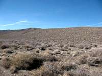
It is difficult to see the roadbed at Emigrant Pass. Make sure you don’t take the trail down to White Sage Flat. You want to go up the obvious rounded ridge to the right and head north. If you can’t see the roadbed, do what I did, just head across the desert uphill to point 5522 on the topo. Once you get up on the ridge you will be able to see the roadbed. There is only one roadbed on the entire route with no forks. It would be difficult to get lost unless it is snowing or dark.

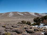
You can make good progress up the ridge as it gently gains elevation over the first 3+ miles to point 6660 on the topo. At this point there is a wide valley ahead and you can see the road down in the bottom of the valley. Follow the road as it descends about 300 ft to the bottom of the valley, cross the valley and the road follows the ramp you can see that climbs from left to right up to point 6842 on the topo. The road wanders around a little bit and goes through another little valley where you lose another 150 ft before going back up to point 7073 on the topo. There is one more valley to cross where you lose about 200 ft in elevation before the road turns north and ascends up to the summit.
The summit has a big cairn and a summit register to sign. There are great views of Telescope Peak to the south and the Sierra Nevada to the north. This is a long hike. My GPS indicated it was 15.6 miles round trip with 3,940 ft of elevation gain. This hike took me 8.0 hrs. I was a little slow because there was snow for about 3 miles that was up to 12” deep.
Essential Gear