
-
 4500 Hits
-
 77.48% Score
-
 8 Votes
|
|
Mountain/Rock |
|---|---|
|
|
28.10721°N / 17.30862°W |
|
|
Hiking, Scrambling |
|
|
2825 ft / 861 m |
|
|
Overview
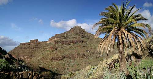 Lomo de Harinero east face Lomo de Harinero east face |
With some 7500 inhabitants Valle Gran Rey in the south-west of La Gomera is the largest habitation on the island. Thanks to half a dozen beaches it is also the most touristic spot on the island. However, when you turn away from the sea, you will encounter a narrow valley which is bounded by walls up to 800m high. To the west you find the long stretched mesa of La Merica while to the east matters are slightly more complicated. Four mountainous structures are lined up from south to north: round topped Tequergenche towers above the sea, followed by the high plain of Las Pilas, again followed by a spiky Montaña del Adivino and long stretched Lomo de Harinero.
The latter is a perfect counterpart to La Merica on the other side of Valle Gran Rey. Long stretched and mesa-like it is topped by twin summits the higher one of which reaches 865m. The eastern slopes are formed like terraces with several ledges on top of each other. The western side - or face to be more correct - drops right down into Valle Gran Rey, revealing the nature and origin of the mountain. Lomo de Harinero - as all other mountains on the island - is of volcanic origin. The predominant form of volcanism on La Gomera was cleft (or rift) volcanism, where lava is emitted from long fissures in the ground. Lose gravel and cinder usually piles up high and only the clefts themselves turn solid after the activity subsides. Around Valle Gran Rey those clefts (or what remains of them) are still buried deep in the ground. Only occasionally you find a rock face made up from reddish basalt. The lava, however is still omnipresent and though wind and water erosion has taken away much of the substance a lot of brittle structures remain.
The Lomo de Harinero west face is a case in point. Here erosion has eaten away most of the lava but several towers remain. The lower reaches of the face are a veritable maze of rocks, many of which have tumbled down during one of the many rockfalls in the area. The barely used hiking trail to El Hornillo is worn into deep ruts and a wrong step may change its path forever.
The main show about Lomo de Harinero, however, is the ledge trail which leads through the west face some 100m beneath the summit. It traverses the face on abroad band which balances 600m above the valley floor. On fine days views into the Valle are exceptional, especially taking into account the many erosion rock towers. Guidebooks will warn you not to venture on the ledge in stormy or rainy conditions, a warning we didn't heed and yet survived. Northern and north-western winds can sweep the ledge and the upper parts of the Lomo and you can have extreme trouble keeping your balance. Wet conditions are dangerous for the descent from the ledge as the brittle footpath gives way easily.
|


Getting There
 View into Valle Gran Rey
In contrast to the large Canarian Islands, La Gomera and El Hierro don't have international airports. Reaching the islands therefore means switching to a local carrier at Tenerife (or any of the other Canarian islands) or use a ferry. Since weather is known to be unstable at the La Gomeran airport near Playa de Santiago, most travel offices will offer the ferry option.
Usually you will be able to book a flight to Tenerife South together with a bus transfer to the harbour at Los Christianos and the ferry to San Sebastian de La Gomera (bus transfer to your hotel on La Gomera is also included).If you want to travel on your own you can use ferries from either La Palma or Los Christianos and Santa Cruz on Tenerife.
There are several trailheads for the climb of Lomo de Harinero. The shortest ascent route starts from El Guro, a village in Valle Gran Rey. It follows a path to Ermita de los Reyes and then up to Degollada de Cherillal. An Alternative but much more difficult route starts at the port of Vueltas through Barranco de Araga, a steep and narrow canyon. Quite naturally you can combine both routes. A third route starts at the hamlet of El Hornillo.
You reach the trailheads from San Sebastian de La Gomera via TF713, the Carretera del Centro, which connects San Sebastian with Valle Gran Rey. After passing the island's highpoint, Garajonay, you reach a three way intersection. Take the left road down to Valle Gran Rey and either park near the main road at El Guro or head down to the harbour of Vueltas, depending on the trailhead. For the El Hornillo trailhead leave the Valle Gran Rey road at one of the switchbacks following the sign "Los Descanderos". There is a parking lot between La Vizcaina and Higuera del Lago.
Red Tape
 Basalt face near the Lomo de Harinero summit
Lomo de Harinero belongs to the Parque Natural de Valle Gran Rey. Though extensive farming is allowed in the park, overnight camping is not. Apart from this the usual rules for natural parks apply. One more note - the western slopes of Lomo de Harinero are very brittle. Take care on the ledge which crosses these slopes west of the summit and be sure not to leave the paths. You might end up in one of the steep barrancos and there are not many reasonable ways which lead out of these.
Accommodation
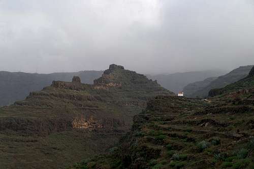
 Lomo de Harinero as seen from the south-east
Of course you can find a lot of hotels, fincas and casas on the island which you can book from any travel office. At Chipude and El Cercado, north-west of the summit, you may find an inn or two for overnight accommodation. In Valle Gran Rey on the other hand you will have everything. As far as I know there are no campgrounds and camping on the beaches is not allowed. One exception might be Playa de las Arenas, which thanks to its history of German Hippies seems to follow its own rules.
Weather Conditions
 Ermitea de Guadeloupe in front of Lomo de Harinero
There are few sites on the web, which deal with the weather for La Gomera. The island just is not very popular with the tourist crowd. The ones you can find are for San Sebastian, which is located on the other side of the island. Generally Valle Gran Rey and its surroundings are pretty weatherproof with sunny days when the rest of the island lies under a thick cloud cover. However the top of Lomo de Harinero is exposed to all kind of winds, which can be very fierce on the Canarias. Climbing to the summit or even crossing the ledges beneath it can become extremely dangerous. Make sure you won't get surprised as weather changes can occur quite suddenly.
The following table gives a rough general overview over the weather on La Gomera, at sea level.
| Month | Jan | Feb | Mar | Apr | May | Jun | Jul | Aug | Sep | Oct | Nov | Dec |
| Avg. day temp.[°C / °F] | 20 / 68 | 20 / 68 | 21 / 70 | 22 / 72 | 23 / 73 | 25 / 77 | 27 / 81 | 29 / 84 | 27 / 81 | 25 / 77 | 23 / 73 | 21 / 70 |
| Avg. night temp.[°C / °F] | 15 / 59 | 15 / 59 | 15 / 59 | 16 / 61 | 16 / 61 | 18 / 64 | 20 / 68 | 22 / 72 | 21 / 70 | 20 / 68 | 17 / 63 | 17 / 63 |
| Water temp.[°C / °F] | 19 / 66 | 19 / 66 | 19 / 66 | 19 / 66 | 20 / 68 | 21 / 70 | 22 / 72 | 23 / 73 | 23 / 73 | 22 / 72 | 22 / 72 | 21 / 70 |
| Rainy days | 11 | 8 | 6 | 5 | 2 | 1 | 0 | 1 | 2 | 6 | 8 | 8 |
Maps & Books
Out of the multitude of maps and books I have been using the following. However, so far I have not found a good hiking map of the island. The one posted here is ok but shows only a fraction of the marked hiking trails.- Maps
- La Gomera
Kompass Map WK231
Kompass Verlag
ISBN: 978-3-85491-015-2
Books
- La Gomera
Klaus Wolfsperger / Annette Miehle-Wolfsperger
Rother Verlag
ISBN 3-7633-4007-6 (German)
ISBN 3-7633-4823-9 (English)