
|
|
Route |
|---|---|
|
|
36.33545°N / 50.98113°E |
|
|
Mountaineering |
|
|
Summer |
|
|
A few days |
|
|
Hike |
|
|
Getting There
From downtown Tehran drive 40 km west to the town of Karaj and take the Karaj-Chalus Road north (This road crosses the Alborz Mountains taking you through the Kandovan Tunnel to the Caspian Coast). 30 km south of Chalus, you will reach the town of Marzan Abad. Turn left and follow a side road into the Sardab Rood River drainage and to the town of Roodbarak. Distance from Tehran to Roodbarak is roughly 200 km.Route Description
Place………….Elevation (m)……….Distance (Km)Vandar Bon…...2300………………...Zero
Tange Galoo…..3250
Camp 3800 m….3800…………………13
Lashgarak the Great.4256………………2
Total…………………………………….........15
From the west end of Roodbarak (elevation 1400 m) drive a dirt road roughly 10 Km to a place called Vandar Bon (2300 m) where the stream and the road split. Right goes to Alam Kooh. Turn left and follow the Sardab Rood Valley to Hesar Chal Plateau. A Four Wheel Drive road follows the river from Vandar Bon to the “Tange Galoo” Narrows (3250 m). If you hire a vehicle to take you to “Tange Galoo”, you will significantly decrease your hiking time. The upper portion of the road may remain blocked by snow until early July.
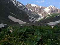 Sardab Rood Valley
At “Tange Galoo” you will have to hike up relatively steep snow banks in a somewhat rocky area. This should not be too difficult for a hiker but in early summer, a pack-mule may have a hard time going over the deep snow. At about 3600 m, the valley opens up and the slopes become very gentle. This is the beginning of the Hesar Chal Plateau. The peaks that surround Hesar Chal begin to come into view. You can camp anywhere in Hesar Chal. We found a nice spot by the stream, at just below 3800 m, where rocks had been piled into a wind breaker wall.
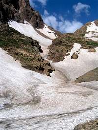 Tange Galoo Narrows
From Hesar Chal, you can follow any path up the northern slopes of Lashgarak the Great. The best approach is probably via a ridgeline on the northwest side of the peak.
 Summit from Hesar Chal