
-
 6236 Hits
-
 76.66% Score
-
 7 Votes
|
|
Mountain/Rock |
|---|---|
|
|
49.15228°N / 7.85335°E |
|
|
Sport Climbing, Scrambling |
|
|
Spring, Summer, Fall |
|
|
1214 ft / 370 m |
|
|
Overview
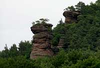
 The north face of the Sternfels main summit The north face of the Sternfels main summit |
Sternfels is another gem in the climbing arena which is formed by the Pfälzerwald mountains around the end of Bärenbrunner Tal, deeply buried in the Südpfalz Climbing Area. It is located to the south of the valley, right above the access road from the hamlet of Schindhard. Among the climbing cliffs of the arena, however, it takes the role of a substitute destination only. The much visited crags on the north of the arena see many more ascends each year. I have visited Sternfels twice already and I have yet to encounter a climbing party on its faces. At the same time there was the never ceasing clanking and jingling of gear on Nonnenfels, Klosterfels and Honigfels across the valley. Yet, Sternfels has a long history of climbing and two of its routes are outright recommendable.
 Sternfels E face Sternfels E face |  Sternfels N face Sternfels N face |  Gap between massif and tower Gap between massif and tower |  Sternfels S face Sternfels S face |
Like many of the climbing cliffs in the Südpfalz Area, Sternfels is made up from more than one crag. There is a massif, sticking out of the surrounding hill and a standalone tower, the so called "Hauptgipfel" or main summit. Both are separated by a narrow, 2m wide chasm, across which the two first recorded ascents led. In 1908 already, Fritz Jung and Karl Petry were the two first persons standing on top of the tower. Their ascent, however, is not rated as valid first ascent since they used a tree trunk to bridge the chasm and head for the top.
The real first ascent ran along the same lines, without the aid of any greenery. Südpfalz pioneers and brothers Fritz Mann and Theo Mann, together with Joseph Baumgärtner and Karl Schenk jumped across the chasm and climbed the remaining 5m across the slightly overhanging east face. Today, this route is only used for descent but rarely. The usual method to get off the crag is rapelling.
 Sternfels S face Sternfels S face |  Sternfels S face Sternfels S face |  Sternfels N and W faces Sternfels N and W faces |
Sternfels, both the main summit and the massif, displays a lot of ledges, especially on north and south face. They can be used by the amateur to get a feeling for exposure but they also form part of the two most interesting routes to the summit. The first - today's normal route - was also pioneered by the Mann Bros. back in 1922. It follows a crack on the south face to a ledge, which it traverses across the whole face, only to return in a wide half circled crack up to the top. The other, Nordwandquergang, starts at the saddle between massif and main summit, jumps across the chasm and then heads across the north face towards the west ridge of the cliff. It was established in 1921 by Karl Schulz and Otto Droßbach.
The massif is a good destination for experienced scramblers. There are two UIAA I routes across the south face to the summit, both following rather slippery ledges. The north face is another story. 30m high, it is overhanging and cut through by prominent cracks. The routes on this face were established doring the sports climbin heyday of 70s and 80s and reach difficulties of UIAA IX+ "Im Gleichgewicht der Seele".
Climbing Routes on Sternfels
 Sternfels main summit seen from the massif. The 1911 original route runs across the face in front
Among the climbing cliffs in the arena of the end of Bärenbrunn Valley, Sternfels is one of the more rarely climbed. It stands a bit apart from the other cliffs and though access is indeed very short, climbers tend to prefer the towers in the east and north of the aena. Still, thanks to the proximity of Bärenbrunner Hof, which serves as a base for all cliffs in Bärenbrunner Tal, both features of Sternfels get their share of climbs. There are two routes, one on the south, one on the north face which are very recommendable. Both make use of the ledges high on the cliff to traverse the whole face before climbing to the top. Exposure on these routes is huge.
The following table has links to the tour database of the PK, where you can find the grades for the free routes plus additional information. Here is the link to the complete route database.
| Feature | Routes link | Summary |
| Sternfels Main Summit | Sternfels Hauptgipfel | 14 routes with variations ranging from 4 - 7+ |
| Sternfels Massif | Sternfelsmassiv | 13 routes with variations ranging from 1 - 9+ |
Getting There
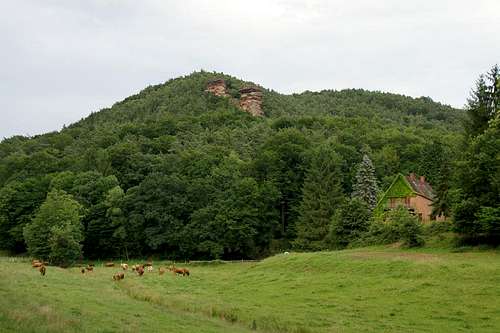 Sternfels above the idyllic Bärenbrunner Tal
The shortest access to Sternfels is a short hike from Bärenbrunner Hof, a farm at the end of Bärenbrunner Tal. You can reach it by a narrow road from Schindhard.
From Frankfurt
There are two possible routes which both take equally long- Via Ludwigshafen
- From Frankfurt take motorway A5 southward to Darmstadt.
- There change to A67 south.
- At Viernheimer Dreieck turn onto A6 west. Leav
- e it at Frankenthaler Kreuz for A61 south.
- At Mutterstädter Kreuz take A65 south until you reach Landau.
- At Landau turn on B10 west.
- At Hinterweidental turn onto B427 south which will take you through Dahn to the exit (left) to Schindhard
- Via Kaiserslautern
- From Frankfurt take motorway A3 west
- At Mönchhofdreieck turn onto A67 south
- At Rüsselsheimer Dreieck take A60 west
- At Kreuz Mainz Süd take A63 south
- At Kreuz Kaiserslautern turn onto A6 west
- At Kreuz Landstuhl turn onto A62 south
- At Pirmasens turn onto B10 east
- At Hinterweidental take B427 south to dahn and Schindhard
From Stuttgart
- Take motorway A8 to Karlsruhe
- At Karlsruher Dreieck turn north onto A5
- Tke the next exit to head for A65
- At Kandel you can leave onto B427 which will lead you to Busenberg. Right after the village a narrow road turns off right (north) to Schindhard. In Schindhard turn right onto the narrow road which leads to Bärenbrunner Hof.
Red Tape
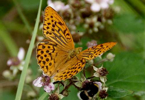 Argynnis paphia
The sandstone of Südpfalz forms lots of caves and overhangs. Though this makes it most interesting for climbers, two species of birds of prey compete for this habitat: the peregrine falcons and the eagle owls. Both are endangered and wherever there is a eagle owl pair found nesting in the sandstone the crag will immediately be closed. Generally this closure lasts from the beginning of each year through Aug. 1st. If breeding is not successful the closures will be canceled even before that date. For a list of closures see the Closure List of PK.
The use of magnesia is not allowed in the whole Südpfalz region. This is rather a directive or an arrangement than an outright law. Thus you probably will get away with using it but do so only when absolutely necessary. Magnesia closes the pores which you find in the sandstone and together they form a smooth surface which will get very slippery in wet conditions. The rule of thumb is to use magnesia in the highest difficulty sections and only extremely sparingly.
A list of guidelines can be found here (in German).
Accommodation
You can camp at Bärenbrunner Hof, right beneath the climbing rocks of Bärenbrunner Tal. There also is a youth hut (think ymca) next to Bärenbrunner Schandarie, but I have no idea how you can obtain the keys.In the villages of Bruchweiler and Bärenbach as well as the town of Dahn you can find pensions, apartments and restaurants.
There is a campground in Bruchweiler-Bärenbach, and the one at Neudahner Weiher, north of Dahn is not far.
Weather Conditions
Maps & Books
Maps
As for maps there is a good overview map (1:50000) by Kompass Verlag but the best ones are the official topographic maps by the state government of Rheinland Pfalz, scaled 1:50000, 1:25000 and 1:5000. All official maps can be found on the web page of Landesvermessungsamt Rheinland Pfalz
1:50000
- Naturpark Pfälzer Wald
Kompass Map WK766
ISBN: 3-85491-523-3
- Pirmasens Süd<
LVA RLP Map L6910
ISBN: 3-89637-193-2
1:25000
- Dahn
LVA RLP Map 6812
ISBN: 3-89637-147-9
Books
There are a number of climbing guidebooks on the region of Südpfalz. The best ones, however, have been published privately and are sold only in selected bookshops of the region.
- Hiking
- Pfälzerwald
B. & J.-Th. Titz
Rother Verlag
ISBN: 3-7633-4268-0 - Klettern im Buntsandstein
U. Daigger, H.-J. Cron
Westpfälzische Verlagsdruckerei St. Ingbert
ISBN: 3-00-0155457-4
- Pfalz ++, Klettern im Buntsandstein
R. Burkard, P. Weinrich
Published privately
- Klettern im Naturpark Pfälzerwald
Naturfreunde Lambrecht
Published privately - Pfalz & Nordvogesen en bloc
A. Wenner, Y. Corby, I. Bald
Panico Verlag
ISBN: 3-936740-19-4
  Climbing Guidebook |
Climbing