
|
|
Route |
|---|---|
|
|
42.94571°N / 4.79484°W |
|
|
Mountaineering |
|
|
Spring, Fall, Winter |
|
|
Most of a day |
|
|
UIAA PD-. Snow up to 50º |
|
|
Class 4 |
|
|
I |
|
|
Page optimized for a screen resolution of 1280 x 1024 pixels
Overview
 On Espigüete summit.
As I use to do, I have mixed two routes for a day. The ascent is by the most classical route in the north face; a medium steep gully, which leads us to the summit through 500 ms of elevation gain, winding between walls and needles, in an unexpectedly easy but impressive way. It was considered a great route for many years but now is regarded as a normal way to reach the summit of Espigüete. The steep is not higher than 50º and this is only in a short passage, the most of the time the inclination is between 30 and 40º. It was climbed for the first time by Aymar d´Arlot, Count of Saint-Saud, Paul Labrouche, François Bernat-Salles, Vicente Marcos and a Tomás, villager of the area, on August 6, 1892 and they expended the night on the summit. The first winter ascent was made by Miguel Ruiz de Ausín, Ángel Ramos, Estanislao Aguado, Luis González, Ernesto Díez, Julio Maiquez and Lauro Vicente on February 2, 1967.
The descent is a very different thing; it consist of go along the eastern ridge, sharp but not very exposed and that alternates walking sections with some easy short scrambling, which difficulty never exceeds UIAA II degree (equivalent to YDS class 4th). There are panoramic and aerial views all along this ridge and it leads directly from the summit to the parking area through 1,100 ms of elevation loss. Espigüete Eastern Ridge was climbed for the first time by Ángel Sopeña y Orueta on July 27, 1946 and, in winter by María del Carmen Muñoz and Luis González on December 29, 1973
The sum of two so different routes, plus a calm and short approximation by the beautiful small valley of Arroyo Mazobres, results in a great mountain day. I think the best conditions for this route is with some snow but not too much. Without snow, the gully of the north face is an uncomfortable climb with areas of loose rock. If there is a lot of snow in the ridge, the descent can be dangerous because of its possible instability; in this case, is better go down by the same route of the north face.
 Eastern Ridge, upper section.
Technical data:
* Accumulated elevation gain and loss: Approximately 1,150 meters.
* Minimum / Maximum Height: 1,350 ms / 2,450 ms
* Time: About 4h45, altogether, not counting stops.
* Difficulty: UIAA PD-. About 400 meters on snow or ice with steep between 30 and 50º in the north face. Many short passages of UIAA I and some of II degree in the eastern edge.
* I did it for the last time on: November 16, 2008.
Getting There
 Cardaño de Abajo.
The logical base for this route is Velilla del Río Carrión; see Guetting There section in Espigüete page to reach that village.
From there, only by car (or walking, of course) you can reach the start point, Pino Llano (that in English means “Plain Pine”, curious name for a place without one single tree), that is not a population but a junction of valleys where there is a parking lot with a water fountain. In Velilla, take the road P-210 for 22 kms, passing Otero de Guardo, Camporredondo de Alba and Cardaño de Abajo; 1km after this last village, turn left on the road to Cardaño de Arriba and continue for 2.5 kms to reach a car park on the left side of the road.
Route Description
Itinerary: Pino Llano - Arroyo Mazobres - Sima del Anillo - cara norte - Espigüete - Punta Este - arista oriental - Pino Llano.
 Map taken from the sheet 106 "Camporredondo de Alba", 1:50,000 of IGN’s MTN50 series.
1.- The ascent: North face
Get out of the parking area of Pino Llano by the wide road that goes up Arroyo (ravine) Mazobres by its right (S) side. Surrounding the base of Espigüete by the north, within minutes you will begin to see, on the left, the successive spurs that fall from the crest of Espigüete. After leaving back a footpath that goes, to the left, to a free hut, the valley widens and you will see in front of you a confluence of ravines. The main watercourse is to the right, while the left one comes from the north circus of Espigüete and therefore is where you must go.
 Espigüete spurs seen from Arroyo Mazobres.
 Ravines confluence; the route goes by the left one (in shade).
Shortly before the meeting of both streams and in view of a waterfall on the right, you'll see on the left (SW) some cairns marking a path, that is sometimes blurred, which goes up by the left ravine. Follow it and arrive at a landing where the ground become narrower, near the Sima del Anillo (Ring Abyss), a deep pit surrounded by a fence to prevent accidents. On the left, you will can see the north face of Espigüete, beyond a small prominence. Leave the footpath to this side and, following cairns, reach the top of it.
 The footpath and cairns to the left ravine.
 Espigüete north side beyond a small prominence.
Since there is already visible the entrance to the gully, on the left (E) part of the base of the north face. Go over there through a karstic plain, where the cairns mark the path that minimizes the up and down between the sinkholes. Once at the entrance of the gully, at the foot of stunning limestone towers, begin to climb by it the north face. The gully access is not very steep but inclination is gradually increasing to almost 30º when the real couloir begins.
 Espigüete North face. The gully on the left.
 Base of the gully.
Suddenly, the gully turns left and steep increases up to 45°, remaining like that for about 150 meters, in the midst of an impressive environment. After that section, there is a small landing, where you can take some air.
 Reaching the couloir.
 Lower section of the gully from above. Hey! I’m not alone!
The gully turns right to go parallel to the mountain face and reaches its more steep passage. It’s a small step, just 4 meters high, where the inclination of the snow can reach 50º or even overcome slightly. Then, there is a gentle snow slope to reach another landing, more or less in the middle of the climb. There, I leave the gully to the east, until to be above of the couloir first section, to take the photo below right; in it, the mountaineer has just passed the step.
 The step in the gully.
 The gully from above.
The final section of the north face route is a wide ledge that climbs diagonally, not exceeding 30º, up the ridge between the two peaks that culminate Espigüete. Upon reaching the summit ridge, turn right (W) and follow the gentle and regulate steep ridge that, if it’s not too wide, it is enough to walk along quietly. You will reach Espigüete summit in a few minutes. In the following link, you can see an interactive 360º panoramic view from the summit.
 The big ledge, last section of north face.
 Reaching the summit ridge.
2.- The descent: Eastern ridge
To return, go back along the ridge to the point where you previously reach it and continue to the east. The ridge between two peaks of Espigüete, that have almost the same altitude, goes down and up about 50 meters. It starts wide and then become gradually narrower and more irregular but it’s always easy. You just have to use your hands to exit the lowest point, climbing two steps, 3 or 4 meters tall each, with little difficulty (I). In any case, and that is for all the descent, every time there is an obstacle slightly stronger on the edge, there are cairns showing how to avoid it, almost always on the left. So, you will get East Point of Espigüete, a good place to take a look back and say a “see you” to this beautiful summit.
 East Point of Espigüete from the main summit.
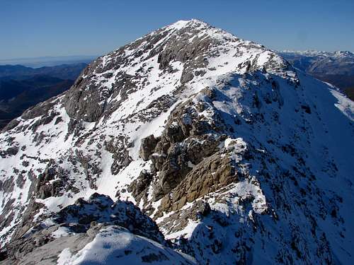 Espigüete summit seen from the East Point.
Continue down the Eastern Ridge, relatively wide and regular during the first 200 meters. Towards the 2,250 meters in altitude, there is a small gap prior to the outstanding point on the ridge you can see in the photo below left. I think it is the most "difficult" of the whole route and is one about 4 meters step, full of handholds but absolutely vertical (II). From that 2,269 ms point, I took the photo right bellow to East Point.
 Upper section of Eastern Ridge from the East Point.
 Upper section of Eastern Ridge from point 2,269.
The descent changes quite a lot from there, as the ridge widens and loses its rocky nature. After a shoulder where the ridge turns left, taking a north-east direction, there is a double rock on the edge but a footpath in the left (NW) side helps to pass easily.
 Point 2,269 and East Point from the wider section of the ridge.
 Middle section of Eastern Ridge, the double rock in the left.
This section is specially beautiful, with the view of Espigüete northeast face to the left and Valley of Cardaño, with Peña Prieta as a background, in front of you.
 The southeast face seen from the eastern ridge.
 Peña Prieta over the houses of Cardaño de Arriba.
After the flanking, when get back to the edge, the ground alternates slabs, to be climbed down with care but has little difficulty, with other sections wider, which can be passed on foot, while you will begin to see the valley bottom. Already very close to finishing the descent, there is a last slab, longer (80 ms) and steeper but easy (I).
 Lower section of eastern ridge, beginning to see the bottom of the valley.
 The last slab in the ridge.
After it, and you'll see the parking lot. To get it, go down by the right (SE) flank of the ridge, where the terrain is more affordable, following the cairns through a very steep slope of loose stones and gravel. Finally you will get the bottom of the valley, a few meters away from the parking lot of Pino Llano.
 Pino Llano and the final descent section by the SE flank of the ridge.
Essential Gear
The only technical equipment required are crampons and ice axe.If there is not snow, I think there are better routes to climb Espigüete but, if anyway you decide to go in summer, then you will need only the adequate clothes and other individual elements for medium / high mountain hiking in temperate areas. I advice only to use hard shoes because the ground in the north face, without snow, is extremly stony, the pebbles are there very sharp and can ruin sportif hiking shoes.
External Links
Regional mountain weather forecast: Spanish government weather agency.If you don't understand completely the text on this page or you want to practice another languages or simply you are a little eager, you can find the original issue in Spanish in the website Pirineos3000.com (La versión original en español de esta página se encuentra en Pirineos3000.com).