
-
 11624 Hits
-
 88.53% Score
-
 27 Votes
|
|
Route |
|---|---|
|
|
46.84408°N / 10.11905°E |
|
|
Hiking |
|
|
Summer, Fall |
|
|
A long day |
|
|
Glacier with crevasses and a nice bergschrund; rock climb UIAA grade I |
|
|
I |
|
|
Overview
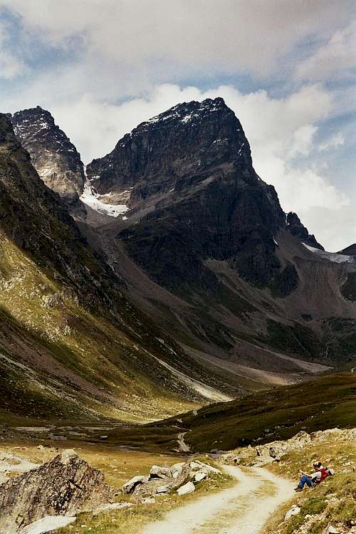 Piz Buin from Tuoi valley (24-08-2006)
The southern route to Großer Piz Buin starts at Chamonna Tuoi (Tuoi alpine club hut) in the Unterengadin valley, Switzerland. From this side, Piz Buin is a monolithic and very impressive rock. The route circles round Kleiner and Großer Piz Buin on their southern and western side and overcomes the summit block via its western slope, united with the normal route from Austria, Wiesbadener Hütte.
In my opinion the ascent from Chamonna Tuoi is the most impressive and most diversified route to Piz Buin with hiking in remote mountain landscape, crossing glaciers, a nice little rock scramble and some dramatic views.
Getting There
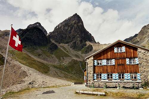 Chamanna Tuoi (24-08-2006)
To get to Chamonna Tuoi, a nice hut of the swiss alpine club with a very friendly staff, you best start at the village of Guarda.
To get there, take road number 184 from Landeck / Inntal valley (exit the highway A 12 at Landeck; toll road) to the austrian / swiss border and the swiss road number 27 to Ardez and the intersection to Guarda.
From the direction of Sankt Moritz or Chur take the road number 27 likewise to the intersection to Guarda after the village of Lavin.
From Rhine valley and Davos / Switzerland, you can choose the Flüela pass road number 28 to Lavin and Guarda.
From Italy / Vinschgau valley, take road number SS 40 and SS 41 to the italian / swiss border and road number 28 via Ofenpass to Zernez, Lavin and Guarda.
Some 200 m before entering the village of Guarda there is a parking area (1581 m, fee required) where you must leave the car. It is the parking area for visiting this old and beautiful Engadin village with all those “sgraffitto houses" (don´t miss that !!) and for the trailhead to Chamanna Tuoi.
 Tuoi valley (24-08-2006) Tuoi valley (24-08-2006) |  Tuoi valley (24-08-2006) Tuoi valley (24-08-2006) |
Follow the signposts to Chamonna Tuoi. You enter the valley of the La Clozza creek on a forest road. At a switchback of the road a trail starts, leaving the road on its right. Follow the trail, crossing the creek and leading up a meadow ridge (Salön) which overcomes a glacial terrace and leads you into the upper Tuoi valley. The trail gently ascends through meadows and light woods and reaches the Alp Suot.
From the Alp follow the forest road further into Tuoi valley. Piz Buin stands towering above the end of the valley. The road leads directly to the Chamonna (2250 m), where the friendly staff is waiting with a welcome drink for you.
Route Description
 Ascent to Cronsel (25-08-2006)
From the Chamonna Tuoi follow the trail which leads up to Fuorcla Vermunt. When you reach the south slopes of Fuorcla Vermunt (at about an altitude of 2500 m), an unmarked trail starts to the left, traversing the south slopes of Piz Buin and steeply leading up to Cronsel, an eye-catching belay southwest of the Chamonna Tuoi.
You can reach Cronsel, too, by crossing the La Clozza creek off trail directly southwest of the Tuoi hut. Start ascending the steep slope between Cronsel and Piz Fliana, always keeping on the right side of the creek, coming down from Plan Rai glacier behind Cronsel. This creek has eroded a steep valley into the moraine debris. There are some feeble foot tracks along the border of this valley. The ascent is very steep. You reach Cronsel on its south side and you will find the above mentioned, unmarked trail, which passes Cronsel on its north side, west of Cronsel amidst the moraine scree and debris below Plan Rai glacier.
 Plan Rai (25-08-2006)
Soon you enter the flat Plan Rai glacier, which lies between Piz Fliana with its impressive hanging glacier on the south side and Kleiner Piz Buin on the north side. Ascend Plan Rai on its right (north) side and go up steeply to the rock plateau of Plan Mezdi. Don´t circle Plan Mezdi on the Plan Rai glacier, this will last very much longer.
 Piz Linard and La Cudera glacier (25-08-2006)
From Plan Mesdi enter La Cudera glacier and turn to the north, still on the right side of the glacier. There might be some tricky crevasses. There are awesome views of Piz Linard and the Silvretta peaks, like Verstanclahorn and Signalhorn, surrounding La Cudera.
Ascend the glacier until you see high above you on your right the Fuorcla dal Cunfin. There is a steep snow and rock slope leading up to the Fuorcla. In fact, there are three notches, the real Fuorcla dal Cunfin is marked with a sign, which shows the swiss / austrian border. Don´t enter the other notches, you will not or not easily be able to enter the Ochsentaler glacier on the austrian side !
To reach Fuorcla dal Cunfin you have to overcome some rocks (UIAA grade I). From the Fuorcla descend on the snow to Ochsentaler glacier and traverse it to the east in the direction of the good visible Großer Piz Buin. Take care of the bergschrund below Fuorcla dal Cunfin and of the crevasses on the glacier.
Below Kleiner Piz Buin the route turns more left to a glacier track, the normal route to Piz Buin from the Wiesbadener Hütte. Follow this track into the col between Großer and Kleiner Piz Buin (Fuorcla Buin).
 Piz Buin Grond and Pitschen from Fuorcla dal Cunfin with Ochsentaler glacier (25-08-2006)
From this col a steep snow, rock and scree chute starts down to Cronsel. This is another, more unusual ascent route from Chamonna Tuoi to Piz Buin. You need good snow for that. For some further information see the additions and corrections section - many thanks to reinhard2 ´s addition and his attached instructive pics from late august 2008.
There is a trail starting at the notch and traversing the west slope of Piz Buin. Follow this trail into the summit rocks. A quite enjoyable rock scramble starts there through chutes and over little rock steps up to the summit scree and snow field which easily leads to the summit cross and the breathtaking summit views. The rock climbing is UIAA grade I / II-, depending on the snow and ice conditions.
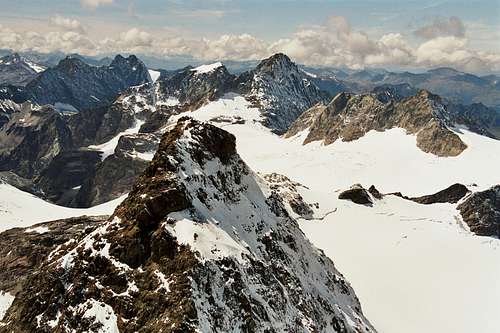
 Fluchthorn as seen from the summit (25-08-2006)
Essential Gear, Mountain Conditions
 Piz Linard and Bernina range as seen from the summit (25-08-2006)
You need full glacier gear, rope, ice axe and crampons.
You need experience with glaciers, crevasses and how to rescue someone out of them - just in case ...
Better hire a guide if you are not sure about it.
Many mountaineers do the traverse from Chamonna Tuoi to Wiesbadener Hütte (or vice versa) and tackle Dreiländerspitze on the next day on their way back to their starting point. This is a very nice 2,5 days round trip in the Silvretta group.
Piz Buin south is surely a summer and autumn hike. It can be done - I think - as a ski hike in winter, too, but I am not totally sure about it.
Maybe somebody can contribute to that.
For the weather forecast see this link.
For avalange bulletin click here.
Accomodations
 Summit view to Verstanclahorn and Piz Buin Pitschen (25-08-2006)
Mountain Huts
Chamonna Tuoi - SAC
Wiesbadener Hütte - ÖAV
Silvrettahütte - SAC
Valley Villages
Guarda
Ardez
Lavin
Susch
Zernez
Scuol
reinhard2 - Feb 8, 2009 4:48 pm - Voted 9/10
South couloir to Fuorcla BuinThis couloir may actually be a good alternative for those wanting to avoid the crevassed glacier parts - as it was the case for me when I was there solo at the end of Aug. 2008. Of course if it is possible or not depends strongly on the actual conditions, but I found it quite feasible even at that late date of the year - see the pic I attached to this page (actually I didn't make it to the Fuorcla because I was very slow and would have had to redescend only in the afternoon, furthermore from the vantage point where I returned - the beginning of the narrow section - the last 10 meters or so appeared nearly vertical, and I was not equipped for that). But I'm sure that many times a year conditions are favorable to go the couloir, if one is strong enough to pass it off the reel. Another point is that I guess it is also possible to go from Plan Mezdi directly over scree slopes to Fuorcla dal Cunfin, thus avoiding the mentioned crevasses of La Cudera glacier (see this pic).