
-
 3222 Hits
-
 74.92% Score
-
 5 Votes
|
|
Route |
|---|---|
|
|
28.96272°N / 13.70613°W |
|
|
Hiking |
|
|
Spring, Summer, Fall, Winter |
|
|
Half a day |
|
|
Hike |
|
|
Overview
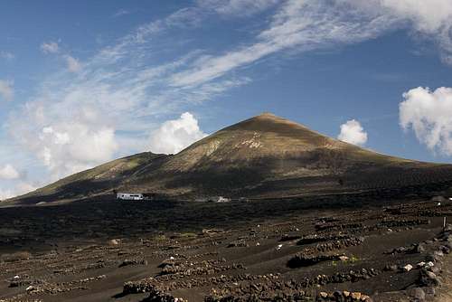 Montaña de Guardilama Montaña de Guardilama |
Montaña de Guardilama arguably is the best lookout peak of Lanzarote. It is located close to the island centre on the San Bartolomé Chain of volcanoes. There are several possible ascent routes, the most popular of which is a stroll through the unique vineyards of La Geria, Lanzarote's wine growing capital. The hike starts at Uga in the west of the mountain and for about half the way it follows dirt roads through the wine growing fields.
The final ascent along the south-west slope of the volcano is a 200m dash along a steep path to the summit. Fortunately - thanks to the age of the mountain - the volcanic cinder has been covered by vegetation so that the ascent is more or less harmless. Biggest difficulty is the intense heat which can scorch the slopes. Combined with the black lapilli cover of the wine pits it can result in dehydration or even sunstroke.
Getting There
See the main page for the itinerary to the trailhead at Uga.Route Description
 Montaña Chupaderos (433m) and Montaña Diama (458m)
- Start altitude: 200m
- Summit altitude: 603m
- Prevailing exposure: South-West
- Type: Hike
- Protection: None
The main orientation challenge of this route is how and where to leave the village of Uga in the south-west of the mountain. From the village center follow Calle Joaquin Rodriguez, which passes the wrestling arena ( a big pit in the ground) to the south. Where it ends turn left and immediately right again (children's playground to the right), hike 50 and turn left into Calle los Arenales. The road turns left in a wide turn. Where it does head straight onwards, climbing a steep path, which leads you to LZ30, the main country highway through the La Geria Region. Walk 200m on the highway northward, then cross it and switch to a dirt road on the opposite side.
 Montañas del Fuego
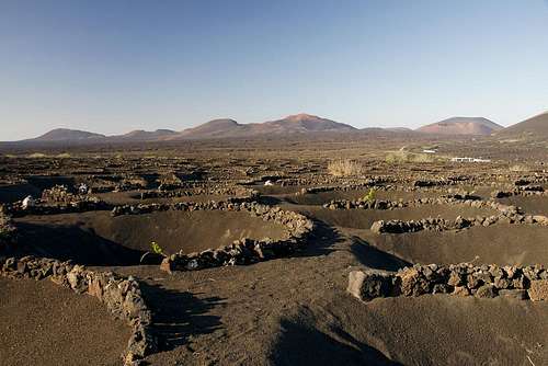
The road, also marked as hiking trail LZ2 leads you deep into the vineyards of Lanzarote, which are located between Montaña de Guardilama, Montaña Chupaderos and Montaña Diama, all three belonging to the old country, the part of Lanzarote, which was created during the eruptions 3000 - 5000 years ago. After a while the road turns right, heading to a saddle between Montaña de Guardilama and Montaña Tinasoria, a huge open crater in the south. The road gets pretty steep and follows an old barranco, a dry creek bed, which is protected from winds in almost all directions. Here - even on winter days - the sun can get scorchingly hot, which is amplified by the black lapilli cover of the vineyards.
 Almond blossom in December
After reaching the saddle head on for some 50 on the other side, passing a fence to the left. Where the fence ends turn left and head towards the south-west slope (ridge) of Montaña de Guardilama. The path is clearly visible but the slope gets steeper as you close in on the summit. The topmost part is a bit of a scramble. Here the path gets ambiguous. Better follow the zigzagging line rather than trying to go up straight. The straight path is rather eroded. Beware of the winds on the summit, which come at you during the last few metres, when you leave the lee (SW) side of the mountain.