
-
 10911 Hits
-
 75.81% Score
-
 6 Votes
|
|
Route |
|---|---|
|
|
47.43012°N / 11.04753°E |
|
|
Skiing |
|
|
Spring, Winter |
|
|
Most of a day |
|
|
Ski hike for good skiiers |
|
|
Overview
 Alpspitze with Oberkar, east ridge (left) and descent route (10-04-2009)
Alpspitze is a very popular ski hike in winter and spring. There are two main ski routes leading to the summit and they use both the east face of Alpspitze and the east ridge.
Normally the ski hikes are done with the aid of Garmisch cablecars because the altitude difference between the valley (740 m) and the summit (2620 m) and the distance which has to be overcome is very much for one day. Moreover you mainly have to use the Garmisch ski slopes for your ascent in the lower parts of the mountain, which might be not very satisfying.
 Overview
Nevertheless mountain purists will start the hike at Garmisch and spend a night at Stuibenhütte, which normally is open in spring during the weekends.
I will describe here the two main ski routes:
Schöngänge ascent
Grieskar ascent
starting from the cableway summit stations of Garmisch ski region:
Osterfelder Kopf
Kreuzeck
Stuibenhütte will be mentioned, too.
Getting There
 Schöngänge, below Bernadeinwand (10-04-2009)
See the SummitPost Alpspitze page for some further informations.
The cableway stations are signposted at Garmisch, you will not miss them. There is a huge parking area around them.
Kreuzeck cableway and Osterfelderkopf cableway are starting nearby.
See this page for the schedules and the prices of the cableways. There are other useful informations about the Garmisch ski and cableway region on this webpage.
From Osterfelder Kopf (2050 m) use the ski slope down to the valley. This ski slope passes a rock notch (at about 1950 m) and enters the cirque below Bernadeinwände, the northeast arete of Alpspitze.
For Schöngänge ascent leave the ski slope here and traverse below the col between Alpspitze and Bernadeinkopf; normally you will see the track up Schöngänge.
For Grieskar ascent follow the ski slope to the summit station of Bernadein ski lift. The ski slope to the Garmisch valley branches off to the left. Go straight on down to Bernadein valley station (1500 m); the ski slope is normally closed in spring. About 100 m before you reach the valley station the ski track branches off to the right.
 Schöngänge, the rock chute (10-04-2009)
From Kreuzeck summit station (1650 m) follow the ski slope, called "Hochalm Skiweg" to the south up to Hochalm and to a notch south of Hochalm with a mountain rescue service hut. This hut is adjacent to the Bernadein ski lift summit station.
For the Grieskar ascent (and for Stuibenhütte) ski down the Bernadein ski slope to the trailhead for Grieskar, mentioned above. After about 300 - 500 m, depending on snow conditions, the skitrack to Stuibenhütte branches off to the left, traverses Gassental and overcomes Stuibenwand, the eastern limitating rock face of lower Grieskar. The final ascent to Stuibenhütte is quickly done.
For the Schöngänge ascent follow the ski slope to the right until you reach the cirque below Bernadeinwände, as described above.
Route Description
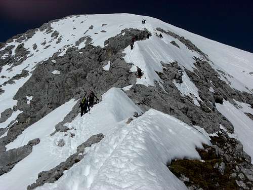
 Near the beginning of the east ridge (10-04-2009)
I will describe Schöngänge ascent and Grieskar ascent separately to the point, where they meet. Both routes use the same summit route and the same downhill route.
Schöngänge ascent
Ascend the steep snow and avalanche (!) slope (in summer a steep scree slope) on the left part of it in the direction of the bottom of the nearly perpendicular Bernadein rockface. The route traverses these upper parts of the slope on a snowcovered ledge. The track leads steeply up to the beginning of a rock chute where iron ropes are fixed. Attention: you will not see this chute from the lower parts of the slope !
Follow the chute and the ropes from below right diagonally up to the left. It is an easy scramble on snowcovered rocks which can be sometimes iced. It is a very exposed ascent though ! You have to carry your skies attached to your backpack for the whole Schöngänge ascent !
You arrive the lower parts of Alpspitze Oberkar and the Bernadeinkopf at the end of the chute. This is where the Schöngänge route meets the:
Grieskar ascent
About 100 m before you reach the Bernadein ski lift valley station the ski route starts to the right. The track enters the woods and traverses nearly level below Bernadeinwände and enters so the lowest parts of Grieskar.
Soon you arrive the timber line. Depending on the snow depth the dwarf pines which grow abundant in Grieskar are covered under the snow.
If so you have several possibilities for your ascent: the left, center or right part of the Grieskar are equally good. Normally there are several ascent tracks to choose.
If the snow cover is bad the left part of Grieskar is best for the ascent (and the descent, too).
 The east ridge (10-04-2009)
If you ascend on the right part of Grieskar you reach the meeting point with Schöngänge ascent directly.
If you choose the center and the left part fpr your ascent, you have to traverse the Grieskar below the rockface of the Alpspitze east ridge to the right to reach the routes meeting point.
Summit Route
From the routes meeting point follow the slope between Bernadeinwände and Alpspitze east ridge into Oberkar. You soon can see a snow covered part of the east ridge to your left. Leave Oberkar and ascend to this level part of the lower Alpspitze east ridge.
You then have to attach your skies on your backpack and continue by foot. The route follows exactly the ridge line; in the middle part there is some easy rock scramble involved. If the conditions are good you can finish the final ascent on your skies again after having passed the rock part of the ridge. Most climbers prefer doing this on foot.
 The rock part of the east ridge (10-04-2009)
Downhill ski descent
Follow the summit east slope, which becomes gradually steeper, down to Oberkar. The steepest part with some huge rocks can be tackeled directly or partly bypassed to the left. This normally depends on the snow conditions. This part is very, very steep !
The descent route now follows the Grieskar ascent route down to Bernadein ski lift. Normally the slopes are very good for skiing and in Grieskar you can widely choose your downhill line. But don´t miss the level traverse to Bernadein ski lift !
You then have to ascend the Bernadein ski slope up to the Bernadein summit station. This is about 300 m of altitude difference and no problem, when this part of the ski region is closed in spring.
You then arrive the ski slope to Kreuzeck. From Kreuzeck choose the ski slope, called "Kandahar" to reach the cableway valley stations. As this ski slope is used for the famous ski world cup races it is perfectly groomed and the snow lasts very long on this slope. Eventually you have to carry your skies for the last 100 m / 200 m altitude in late spring.
Variations
The Nordwand Ferrata is now very popular in winter / spring.
Alpspitze northface is nowadays popular, too, for excellent skiers.
Instead of traversing into Oberkar you can follow Grieskar up to its end (Grieskarscharte 2465 m) between Alpspitze (north) and Hochblassen (south). Follow the southwest arete up to Alpspitze (easy rock scramble).
From Grieskarscharte Hochblassen can be reached via a snow chute, passable only in late spring and early summer. Hochblassen normal summer route starts at Griesscharte, too, but traverses the northwest slope of Hochblassen into the notch between Hochblassen and Vollkarspitze and uses the exposed west arete (UIAA grade I, II).
  |
Essential Gear & Mountain Conditions
 Near the summit (10-04-2009)
You need full ski hike gear and avalanche gear.
For the Schöngänge ascent crampons are highly recommended because of the danger of iced rocks in the upper parts of the ascent.
The ski ascents are mainly done in spring starting from end march to mid-may, depending on the snow conditions and the snow heights. The days are longer, warmer and you often will find good corn snow conditions for you downhill fun. As there are many eastern exposed slopes the snow can become soon very deep in spring.
Nevertheless Alpspitze is becoming a ski aim in winter, too. Avalanche danger is much higher in winter and a tragic accident in Oberkar with a huge avalanche and several dead shows that Alpspitze should not be underestimated although it is a very popular ski hike and on good weekends you will not be alone on top of the summit.
Be aware that the summit slope down to Oberkar is very steep. At the steepest part there are normally some rocks poking out of the snow. You need to be a good skier, a fall in this part of the slope is not advisable at all.
Maps & Links
 At the summit (10-04-2009)
As map I would recommend:
Alpenvereinskarte
scale 1 : 25.000
Wetterstein und Mieminger Gebirge
Mittleres Blatt, Nr. 4/2
The bavarian avalanche bulletin can be checked here.
Use the austrian weather forecast for Tirol; it is effective fo Wetterstein, too.
Difficulty
Difficulty: Advanced - DifficultReasons: The ascent route via Schöngänge must be rated "difficult" - you need ice axe and crampons, there is some rock scramble in exposed terrain and you carry your skies.
The ascent route via Grieskar is much easier. The downhill descent from Alpspitze to grieskar is in some partes VERY steep so this is advanced to difficult terrain
Grades:
Beginners:
easy ski-hikes with moderate altitude difference, easy routes and simple downhill slopes
Advanced:
Ski hikes for the more experienced, due to higher altitude differences and/or longer and more demanding routes including steep or exposed parts and steeper downhill slopes
Difficult:
Only for experienced ski hikers and mountaineers; high altitude differences (> 1.500 m), long and demanding routes including steep and difficult route parts and/or rock scrambling and/or parts with crampons / ice axe to get on a summit; steep, exposed and / or narrow downhill slopes
The difficulty rating shall give you a first advice about how demanding the ski route is. It is my personal rating. The reasons for the rating are given in the description. They are effective for “normal conditions” like good weather, Normal snow conditions and a moderate avalanche danger. Due to bad conditions (weather, snow, avalanches) a lower grade can tend to be more difficult.