
-
 49982 Hits
-
 94.23% Score
-
 47 Votes
|
|
Area/Range |
|---|---|
|
|
47.43000°N / 11.05000°E |
|
|
Hiking, Mountaineering, Trad Climbing, Sport Climbing, Aid Climbing, Big Wall, Via Ferrata, Skiing |
|
|
Spring, Summer, Fall, Winter |
|
|
9718 ft / 2962 m |
|
|
1 - Overview
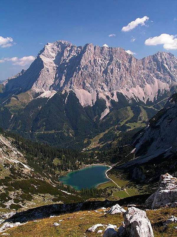 Zugspitze and the 1000+m walls of the Zugspitzplatt south-east faces Zugspitze and the 1000+m walls of the Zugspitzplatt south-east faces |
Wetterstein– do I need to translate the name into English? I guess not. The small mountain range is home to Germany’s highest mountain, Zugspitze, you might have heard about the Jubiläumsgrat Ridge, perhaps even heard about Höllental Valley. Garmisch Partenkirchen and Mittenwald at its northern and eastern sides are well known and easily accessible touristic towns. And look at the current state on SP – you’ll find another ridge and two more summits – isn’t there more about the range?
To be sure there is. Though the Wetterstein Range definitely is overshadowed by its highest summit and the brouhaha around it, it is more than just the range that houses Zugspitze. The range is located between the Ammergau and Lechtal Alps to the west, the Karwendel Range to the east and the Mieming Chain to the south. To the north no major mountain range follows. The Wetterstein Range is part of the Northern Limestone Alps and does honour to its location. You will find just about any kind of limestone here, in some parts even the brittle main Dolomite. Apart from that the rock quality is generally quite good so that the mountain ranges houses hundreds of technical routes of all qualities and difficulties. Especially in its western and southern parts you can numerous long and very difficult rock climbs ranging up to upper UIAA IX grade.
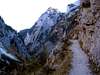
For the experienced hiker (and tour skier) Wetterstein offers also a number of interesting trails most of which culminate on Zugspitze. There are the ridge traverses of Jubiläumsgrat and Wettersteingrat, several interesting crossings and the ascent routes through Höllental and Reintal which both close in on you as you get closer to the valley ends. All hiking routes are moderately difficult – they can be long, climb huge elevation differences; in short you need a certain amount of alpinistic experience.
Obviously Zugspitze with its cable-cars trains, restaurants and hotels is one of the most crowded spots in the Alps (and on SP btw – 13000 hits for a mountain that doesn’t even reach 3000m!), the ascent routes are crowded too and in the valleys you will find herds of people. But apart from these places, especially on the Waxenstein and eastern Wetterstein ridges you can still find solitude. Some of the places are accessible only for experienced rock climbers. Great contrasts indeed. Elevation differences are also impressive. Just look at the Wetterstein image taken from the north-west: a mountain rising for more than 2500m above the Loisach Valley. On the average you will find differences of 1500m – 2000m between the villages and the summits.
2 - The Wetterstein Range on SP
  |
The Wetterstein Range is composed of three large ridges which all combine in one point, Zugspitze. From the north the Waxenstein / Riffelkamm Ridge leads toward the summit, from the north-east it is the Blassenkamm Ridge. The southern part of the range is composed of the long Wetterstein Ridge (divided in two parts here), running east to west. Around Zugspitze to its south you find a high plain, Zugspitzplatt, which is surrounded by a cirque of mountains and which still contains an increasingly small (should I say decreasingly?) glacier; Schneeferner. To the east of the range is a small separated subgroup, the so called Arnstock.
3 - Zugspitze and Zugspitzplatt
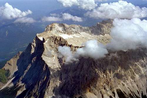 Zugspitze with Wetterkante, Schneefernerkopf and Neue Welt from south-west
This is the central hub of the Wetterstein Range. The three main ridges meet here and form a karst high plateau, the Zugspitzplatt. The plateau is surrounded by mountains which barely are higher than the plain but which drop off for more than 1000m to the western and south-western sides. The Zugspitzplatt is home to the only glacier of the group, the shrinking Schneeferner. Access to the subgroup is easy (but expensive) by using the cable-cars to Zugspitze itself. Everything is VERY crowded

- Zugspitze (2964m)
![]()
![]()
- Zugspitzeck (2820m)
- Sonnenspitzl (2600m)
- Schneefernerkopf (2875m)
![]()
![]()
- Wetterspitzen (2700m – 2750m)
- Wetterwandeck (2699m)
- Westliche Plattenspitze (2678m)
- Östliche Plattenspitze (2679m)
![]()
- Östlicher Gatterkopf (2476m)
- Mittlerer Gatterkopf (2480m)
- Westlicher Gatterkopf (2490m)


4 - Riffelwandkamm and Waxensteinkamm
 Riffelwandkamm as seen from The Zugspitze summit
The shortest of the three ridges is separated at Riffelscharte and carries different names for both parts of the ridge. The south-western part between Zugspitze and Riffelscharte is called Riffelkamm, while the north-eastern part is called Waxensteinkamm, both named by the most impressive summits. The ridge runs off from Zugspitze in north-easterly direction. The south-eastern slopes of the ridges are somewhat shallow and pose orientation problems mostly. The north-western faces are steep, almost vertical and are home of a great many long climbing routes.
- Große Riffelwandspitze (2626m)
- Kleine Riffelwandspitze (2536m)
- Riffelköpfe (2459m, 2412m, 2403m)
- Riffeltorkopf (2230m)
- Südliche Riffelspitze (2263m)
- Nördliche Riffelspitze (2242m)
- Schönangerspitze (2273m)
- Schöneckspitze (2258m)
- Hinterer Waxenstein (2268m, 2253m)
- Großer Waxenstein (2277m)
![]()
- Zwölferkopf (2232m)
- Kleiner Waxenstein (2163m)
5 - Blassenkamm / Jubiläumsgrat
 Jubiläumsgrat by Bryan Benn
The late Rahel Maria Liu created an own page fort the Jubiläumsgrat Ridge. It is one of the best known ridge traverses in the northern Alps and very popular among the Ferratisti / Klettersteiggeher. The ridge runs in east-north-easterly direction and has a main summit in Alpspitze.
- Innere Höllentalspitze (2737m)
![]()
- Brunntalkopf (2265m)
- Mittlere Höllentalspitze (2740m)
- Äußere Höllentalspitze (2716m)
- Großer Kirchturm (2514m)
- Kleiner Kirchturm (2368m)
- Vollkarspitze (2638m)
![]()
![]()
- Hochblassen (2698m, 2706m)
![]()
![]()
- Blassenspitze (2400m)
- Hoher Gaif (2288m)
- Alpspitze (2629m)
![]()
![]()
- Höllentorkopf (2150m)
- Bernardeinwand (2134m)
- Schwarzenkopf (1819m)
![]()


6 - Westlicher Wettersteinkamm
This Ridge, which runs in easterly direction from Zugspitzplatt, has also been described on SP already. The ridge traverse, which is far less popular than the Jubiläumsgrat traverse is nevertheless equally impressive and difficult. Moreover there are hundreds of easily accessible climbing routes here, which can be reached from both sides of the ridge. Consequently they are considerably popular.- Hoher Kamm (2376m)
- Kleiner Wanner (2546m)
- Hochwanner (2746m)
![]()
- Höhlenkopf (2403m)
- Hinterreintalschrofen (2674m)
- Jungfernkarkopf (2300m)
- Kleiner Hundsstall
- Großer Hundsstall
- Kleiner Hundsstallkopf (2323m)
- Gamsanger (2116m)
- Großer Hundsstallkopf (2559m)
- Hochwannenkopf (2230m)
![]()
- Haberlenz (2206m)
- Predigtstuhl (2241m)
![]()
- Nördlicher Zundernkopf (2250m)
- Mittlerer Zundernkopf (2324m)
- Südlicher Zundernkopf (2400m)
- Nordwestlicher Zundernkopf (2324m)
- Oberreintalschrofen (2523m)
- Oberreintalturm (1940m)
- Oberreintalköpfe
- Scharnitzspitze (2463m)
- Oberer Schlüsselkarturm (2350m)
- Unterer Schlüsselkarturm (2200m)
- Schlüsselkarspitze Westgratturm
- Schlüsselkarspitze (2537m)
![]()
- Dreizinkentürme
- Pantherkopf (2300m)
- Gehrenspitze (2367m)
![]()
- Leutascher Dreitorspitze (2673m)
![]()
- Westlicher Söllerkopf
- Östlicher Söllerkopf
- Öfelekopf (2469m, 2449m)
![]()
- Partenkirchener Dreitorspitze (NO: 2606m, M: 2622m, W: 2633m)
![]()
![]()


7 - Nordöstlicher Wettersteinkamm
The north-eastern part of the 16km long Wetterstein Ridge is the most solitary region of the whole range. The access routes to the summits are long and thus they are rarely crowded. The valley to the north however can be easily reached from Mittenwald and thus they are quite popular.- Signalkuppe (2486m)
- Bayerländerturm (2507m)
- Oberer Berggeistturm (2250m)
- Unterer Berggeistturm (2000m)
- Oberreintaldom (2371m)
- Westliche Törlspitze (2427m)
- Östliche Törlspitze (2443m)
- Musterstein (2478m)
![]()
- Hirschbichlkopf
- Zirbelkopf (2300m)
- Wettersteinwand (2483m)
![]()
- Obere Wettersteinspitze (2296m)
![]()
- Untere Wettersteinspitze (2152m)


8 - Arnstock
 Arnstock and Wettersteingebirge seen from Karwendel
This little subgroup is separated from the main bulk of the Wetterstein Range by the Leutaschtal Valley. It has three main summits which – thanks to their outside location – are all perfect viewpoints.
- Große Arnspitze (2196m)
![]()
- Mittlere Arnspitze (2130m)
- Arnplattenspitze (2172m)
![]()
![]()


9 - Getting There
Since the Wetterstein Range is such a compact group which is well separated from the surrounding mountain groups it is very easily accessible from all sides. Main towns are Garmisch Partenkirchen to the north and Mittenwald to the east. On the Tyrolean side the main villages are Seefeld and Ehrwald. All are located very close to the group. The nearest airports are Munich and Stuttgart in Germany and Innsbruck in Austria and the following itineraries are given from them respectively.- North
Garmisch Partenkirchen and Mittenwald can be reached most easily from Munich via motorway A95, which end a few km before Garmisch. The following road, dubbed E533 connects Garmisch, Mittenwald and Seefeld.
- West
- The western part of the Wetterstein Range (Ehrwald / Tyrol) can be reached from Munich via A95 to Garmisch and B23 (Germany) / B187 (Austria).
- From Stuttgart follow A8 to Ulm, there switch to A7 south to Füssen. The motorway is not yet completely finished so expect about an hour along common roads until you reach Füssen. From there take B179 to Reutte, Lermoos and Ehrwald.
- From Innsbruck take motorway A12 to Telfs. There switch to B189, which at Nassereith you leave for B179 across Fernpass to Ehrwald.
- The western part of the Wetterstein Range (Ehrwald / Tyrol) can be reached from Munich via A95 to Garmisch and B23 (Germany) / B187 (Austria).
- South-East
For Seefeld and Leutasch either follow the directions to Garmisch and Mittenwald if you start out from Munich or take A12 from Innsbruck to Kematen, where you head on B177 / E533 which leads you to Seefeld, Mittenwald and Garmisch.
10 - Red Tape
You are in the border region between Germany and Austria. Though generally you don’t have to worry about controls anymore it is safest to bring id or passport. Apart from this several parts of the range are set aside as nature preserves which means the usual care for plants and animals.There are fees for parking lots and some of the access roads. You may pay up to 5€ each
11 - Mountain Huts and Refuges
There are a great number of huts, alms and pastures in the range, serving almost any of the spots in the area. The following table gives an overview.11.1 - Huts
| Refuge / Hut | Height | Summer | Winter | Tel. | Thumbnails |
| Wiener Neustädter Hütte | 2213m | beg. July – end Sept. | closed | +43 676 4770925 |  |
| Waxensteinhütte | 1380m | n.a. | n.a. | n.a. | |
| Höllentaleingangshütte | 1045m | mid May – mid Oct. | closed | + 49 8821 8895 | |
| Höllentalangerhütte | 1381m | end May – mid Oct | closed | + 49 8821 8811 |  |
| Knappenhäuser | 1527m | n.a. | n.a. | n.a. | |
| Kreuzeckhaus | 1652m | mid May – beg Nov. | mid Dec. – mid Apr. | +49 8821 2202 | |
| Kreuzjochhaus | 1600m | all summer | all winter | +49 8821 9430323 | |
| Hochalm | 1705m | n.a. | n.a. | n.a. | |
| Stuibenhütte | 1620m | n.a. | n.a. | info@stuibenhuette.de | |
| Rießerkopfhütte | 1130m | n.a. | n.a. | n.a. | |
| Garmischer Haus | 1320m | n.a. | n.a. | +49 8821 57062 | |
| Reintalangerhütte | 1366m | end May – mid Oct | closed | +49 8821 2903 |  |
| Knorrhütte | 2051m | end May – beg Oct. | closed | +49 8821 2905 |  |
| Schneefernerhaus | 2650m | n.a. | n.a. | n.a. | |
| Münchner Haus | 2957m | mid May – end Sapt. | Closed | +49 8821 2901 |  |
| Zugspitzbahnhotel | 2950m | n.a. | n.a. | n.a. | |
| Höllentalgrathütte | 2700m | all summer | all winter | +49 8153 952392 | |
| Oberreintalhütte | 1530m | June – mid Oct | closed | +49 8821 2701 | |
| Schachenhaus | 1866m | June – mid Oct. | Closed | +49 8821 2996 | |
| Wettersteinalm | 1464m | June – September | closed | n.a. | |
| Meilerhütte | 2376mm | mid June – beg Oct. | closed | +49 8821 2701 |  |
| Erinnerungshütte | 2050m | n.a. | n.a. | n.a. | |
| Wangalm | 1751m | June – mid Oct. | closed | +43 664 3330611 | |
| Wettersteinhütte | 1717m | mid May – mid Oct. | md Dec. – end March | +43 664 4153747 | |
| Hämmermoosalm | 1419m | n.a. | n.a. | +43 5214 6955 | |
| Rotmoosalm | 1810m | n.a. | closed | +43 664 4226149 | |
| Tillfußalm | 1380m | end May – mid Oct. | closed | +43 664 2735188 | |
| Steinerne Hütteln | 1920m | n.a. | closed | +43 663 854533 | |
| Ehrwalder Alm | 1493m | n.a. | n.a. | +43 5673 2534 | |
| Arnspitzhütte | 1955m | all summer | all winter | +49 89 1573566 |
11.2 - Bivouacs
As for Bivouacs I know only one:
| Bivouac | Height | Thumbnails |
| Schüsselkarbiwak | 2530m | |
| Hoellentalgrat hut |  |
12 - Accommodation
Each of the towns and villages of the area has a homepage with the possibility to book hotel rooms and apartments. Follow one of the links below.13 - Weather Conditions
Weather links:Webcams:
14 - Maps & Books
14.1 - Maps
- Wettersteingebirge, Zugspitzgebiet
Kompass Map WK5
1:50000
ISBN: 385491007X
- Wetterstein, Karwendel, Seefeld, Leutasch, Garmisch Partenkirchen
Freytag & Berndt Map
1:50000
ISBN: 3850847489
- Garmisch-Partenkirchen, Mittenwald
Kompass Map WK790
1:30000
ISBN: 3854915810
- Garmisch-Partenkirchen, Wetterstein, Werdenfelser Land
Freytag & Berndt Map
1:25000
ISBN: 3850848159
- Alpenvereinskarten of the German Alpine Club
- 4/1 Wetterstein und Mieminger Gebirge, westl. Blatt, Art.Nr.: 100007
- 4/2 Wetterstein und Mieminger Gebirge, mittl. Blatt, Art.Nr.: 100008
- 4/3 Wetterstein und Mieminger Gebirge, östl. Blatt, Art.Nr.: 100009
- 4/1 Wetterstein und Mieminger Gebirge, westl. Blatt, Art.Nr.: 100007
14.2 - Books
14.2.1 - Hiking
- Rund um die Zugspitze
Dieter Seibert
Rother Verlag
ISBN: 3-7633-4264-8
- Seefeld- Leutasch
Dieter Seibert
Rother Verlag
ISBN: 3763340173
- Wetterstein und Mieminger Kette
Helmut Pfanzelt
Gebietsführer
Rother Verlag
ISBN: 3-7633-3129-8
- Rund um die Zugspitze. Werdenfelser Land
Siegfried Garnweidner, Barbara Hörmann
Kompass Wanderführer 923
ISBN: 3854912838
14.2.3 - Climbing
- Wetterstein
Stefan Beulke
Alpenvereinsführer
ISBN: 3-7633-1119-X
Sebastian Hamm - May 21, 2006 12:43 pm - Voted 10/10
Muenchner hutI have added the Muenchner hut to SP. Please add it to Wettersteingebirge. Object ID: 195168 Salü Sebastian
mvs - Sep 4, 2007 4:58 pm - Voted 10/10
BernadeinwandHi Gangolf, I added Bernadeinwand. You could make a link to that peak from your list of peaks around Alpspitz. Thanks! --Michael
Gangolf Haub - Sep 5, 2007 2:50 am - Hasn't voted
Re: BernadeinwandI added it to the section "Wetterstein on SP". Good route page but the main page is still a bit shortish. Couldn't you add some directions how to get to Hammersbach? Never heard of the village myself .o)
mvs - Sep 5, 2007 4:38 am - Voted 10/10
Re: BernadeinwandSure thing I added it. I realize I made the town sound very mysterious...perhaps it's populated by elves and only visible under a full moon :P