
|
|
Canyon |
|---|---|
|
|
37.86510°N / 111.63586°W |
|
|
Hiking |
|
|
Spring, Summer, Fall |
|
|
Overview
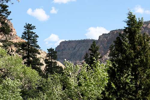
As part of the namesake of the Box-Death Hollow Wilderness Area, The Box is a canyon with no small reputation among its visitors. The Box is a very scenic and wild canyon in Southern Utah that offers solitude and variety to its explorers. Extending from high on the southern slope of the Aquarius Plateau, also known as Boulder Mountain, The Box plunges far below the cool forest and transitions into the heat of the Escalante area desert. Come and speculate how water, through ages of time, has carved a canyon more than 1,000 ft. deep into the earth. As you gasp in wonder about the beauty of this canyon, you may also reflect upon how nature has preserved you a moment to enjoy such a magical place. Please consider your role in helping to preserve this gorgeous canyon as you visit, keeping the magic alive for future visitors and its many over-looked and permanent residents.
Features
The Box is truly a gem of beauty, but a hidden one. Without the surefire tourist magnets of arches, slot canyons and cascading waterfalls, The Box sees fewer visitors than the surrounding attractions of the Escalante area. But, make no mistake; if its beauty you are looking for, then The Box is the place. You just might have the place to yourself when you come to visit.
Here, in The Box, you will find these features:
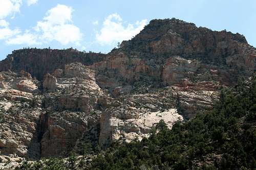
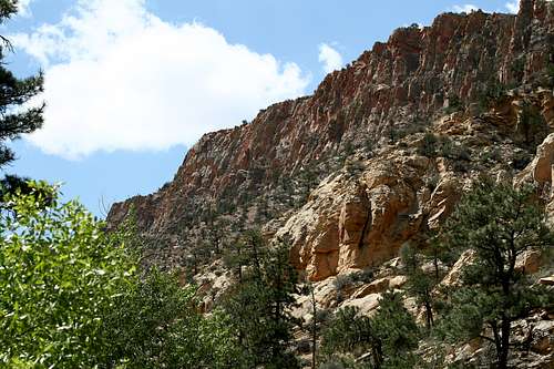
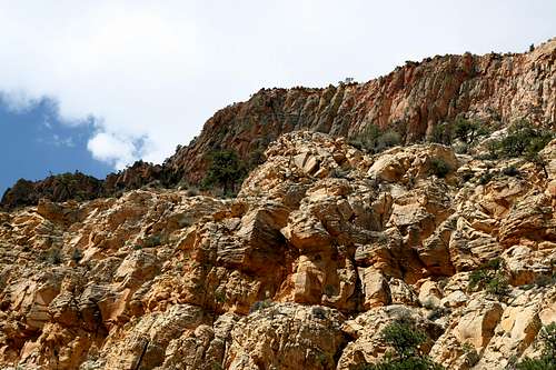
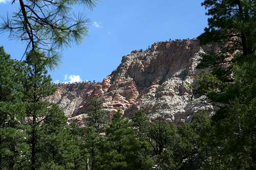
A beautiful sandstone canyon that reaches 1,400 feet in depth in some places and is normally at least 800 feet deep throughout most of the hike.
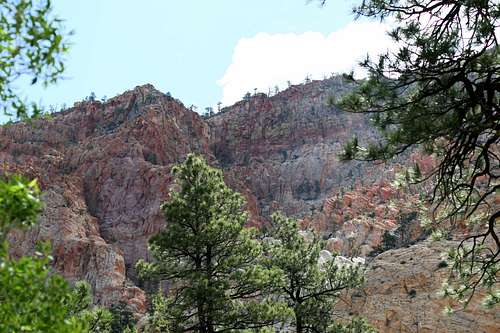
The canyon walls feature a variety of colors, even a lime-green glaze over some of the highest layers of sandstone.
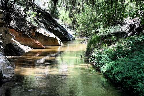
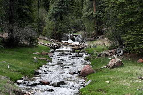
Pine Creek
Pine Creek, which runs the length of the canyon, is stunningly attractive. The trail is very near and dear with this cold, clear stream.
Experience the transition of climate as you hike from one end to the other. Cool shady forests typify the Upper Box, while the hot, sandy desert is typical of the Lower Box. Note the change in rock layers, trees, wildflowers, birds, mammals and even the soil.
Everything else that goes with a wilderness area experience; not the least of which is the peace and quiet.
History
Three quick bits of history:
1) Hell’s Backbone Road was constructed in the 1930s.

Hell's Backbone Road
2) The Civilian Conservation Corps completed many projects in the area during the same time period, including bridges and fire-watching towers. You will see some historical markers regarding this information along the road to the Upper Box.
3) The Box was designated a wilderness area with the Utah Wilderness Act of 1984. The Box was almost not included in the bill due to the interests of cattle ranchers in the area.
Getting There & Trailheads
The best access to this trail is from the town of Escalante, UT. Highway 12 is the only paved access to this town. Turn off of Highway 12 at the east end of town. The street is marked 300 East. Highway 12 also has a road sign that indicates access to Posey Lake from 300 East. The road you will be traveling is named Hell’s Backbone Road, and is also alternatively named Posey Lake Road. The road is very easy to follow and does not require four-wheel drive or a high clearance vehicle to get to the trailheads. The road begins by leaving town and descending to the Escalante River. You will drive by farm and pasture lands for about two miles as you leave town. Eventually, you will leave most of civilization behind and the road turns into dirt after a little more than 3 miles from Highway 12. The dirt road is graded well, but expect occasional washboard stretches.
Here's a website with more information on Scenic Highway 12
Here's another link for Highway 12

Lower Box Entrance
Lower Box
After a little more than 7 miles from Highway 12, you will come to the road that takes you to the Lower Box Canyon access point. A sign should clearly indicate the trail access. There will be a short spur road that will take you to the trailhead. This road does not require four-wheel drive, but you will need some high-clearance on your vehicle, as you will drive in and out of a dry creek bed.

The Box Trailhead
Once you arrive at the end of the spur road, there will be a parking area and large sign and trail register. The sign will inform you on some of the rules regarding this particular wilderness area. The beginning of the trail is easily found.

Trailhead Road Sign
Upper Box
To access the Upper Box Canyon trailhead, continue driving up the Hell’s Backbone Road. The road will lead you out of the juniper trees and dry hills and into the cool shade of a ponderosa pine forest. Once in the forest, you will eventually encounter an intersection that will take you to Posey Lake if you take the left road. Stay to the right in order to continue on to the Upper Box trailhead.
The road will cross two major creeks before reaching the trailhead: Hungry Creek and Deep Creek. About one or two tenths of a mile before crossing Pine Creek, the turnout for the Upper Box Canyon will appear. There should be a clear sign indicating the trail access. Park on the east side of the road, closest to the ravine, which cradles Pine Creek below. You will know if you drove too far if you see a sign for a road that takes you to Blue Spruce Campground, which is shortly after the Upper Box access.

Access to the Upper Box
After you park on the side of the road, the beginning of The Box trail will not be immediately apparent. The parking area sits on the edge of a slope, which descends about 80 feet in elevation to the flowing creek. A faint footpath can be followed down to the creek. Once at creek level, gaze downstream and there you will see the trailhead and trail register next to the bank. It will look identical to the one at the Lower Box access point.
There are no toilets at either trailhead.

Road Mileage
Highway 12 to the Lower Box Trailhead turnoff: 7.2 miles
Highway 12 to the intersection for the road to Posey Lake: 13.5 miles
Highway 12 to the Upper Box Trailhead turnout: Almost 18 miles
Upper Box Trailhead turnout to Blue Spruce Campground: 0.6 miles
When to Go
The best times to visit this canyon would generally be spring and fall. You could go in the summer, but it would be very hot. Snow does fall in this canyon during the winter. The snow should be gone by May. Remember that the top of the canyon reaches over 8,000 ft., where Escalante rests around 5,800 ft. There will be a large variation in climate and weather between both locations. Treat this area like you would any other mountain environment, i.e. thunderstorms are likely in the afternoon, etc.
Current Conditions
Visit this link to NOAA for a current forecast
Snow depth for the Aquarius Plateau
Utah Road Conditions
Please contact the forest service for further details
Escalante Interagency Office
PO Box 246
755 West Main
Escalante, UT 84726
435-826-5499
Red Tape

Wilderness Rules Apply
This canyon lies within the boundaries of the Box-Death Hollow Wilderness Area and is administered by the Dixie National Forest. One thing noticeably different is that horses cannot get into the canyon. Pedestrians are the only visitors allowed. A zigzag gate at both ends of the canyon will keep ATVs and horses out.
No permits are necessary. Sign in at the trail register.

Please follow normal wilderness area guidelines such as these:
Plan ahead and prepare
Travel and camp on durable surfaces
Dispose of waste properly
Leave what you find
Minimize campfire impacts
Respect wildlife
Be considerate of other visitors
Follow this link for further details
Route
Trail Data

Trail Length: About 8.5 miles
Lower Box to Deep Creek: About 4.5 miles
Deep Creek to Upper Box: About 3.6 miles
Upper Box to the NE fork: About 1.75 miles
Following Deep Creek to Hell's Backbone Road: About 2 miles
Upper Box Trailhead to Blue Spruce Campground (along road): 0.6 miles
Lower Box Elevation: 6,440 feet
Upper Box Elevation: 7,740 feet
Elevation of Confluence with Deep Creek: 7,010 feet
The trail is very straightforward. The idea is to hike from one end of the canyon to the other. But, from the looks of the trail register at the Lower Box Access, hiking into The Box about a mile or two and then turning around satisfies most visitors. It appears to be rare that a visitor is interested in trekking the entire length. The Lower Box sees more visitors than the Upper Box portion.
 Entering the Box
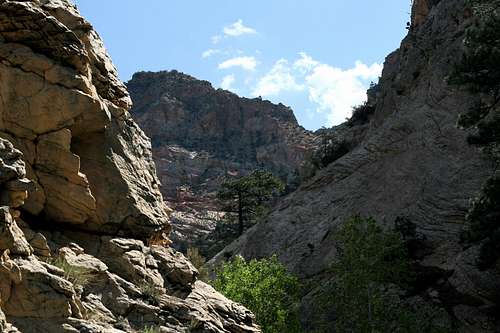
Although the Lower and Upper Box follow the same plan of following Pine Creek through the canyon, the portions are not equal in difficulty. The Lower Box sees more traffic, and so the trail is more easily distinguished. The canyon is also very wide in the Lower Box, which prevents the path from getting too rugged.
Dense Cover
The Upper Box is quite different. This area is much more narrow than the Lower Box. This condition funnels all the rock falls and tree falls into the confines of the narrow gorge. The trail is often pulverized and you will need to navigate around these obstacles. In one area, it is necessary to actually kneel down and crawl under two trees that block the path. Besides these obstructions, the trail is usually discernable but not maintained. These conditions of the Upper Box are most prevalent north of the confluence with Deep Creek.
There are two large side canyons of The Box. The first one heading upstream is Deep Creek, which veers to the northwest. The author did not explore this canyon, but has researched to know that it will eventually lead a hiker up to the Hell’s Backbone Road somewhere between the Posey Lake intersection and the Upper Box trailhead. This could be made into a fine loop hike from the Upper Box trailhead. Deep Creek also has clear, flowing water.

Keep Out!
The next major side canyon does not have a name, but is near the top of The Box and veers to the northeast. The entrance to this canyon is very narrow and is guarded by a large keeper pothole, preventing entrance from the casual hiker.

Pine Creek Crossing
This saying goes for the entire hike: You will cross the creek a lot! I did not count, but it seemed like I crossed the stream at least 20-30 times. Luckily, the crossings are normally a simple hop along creek stones. But, there were at least two times where I did not have the luxury of stones, and I had to step on the bottom of the creek, which gave my boot a quick fill of cold water. Some crossings require very athletic jumps to keep your boots dry. But, just expect to get your boots wet a least a couple of times.
Most of the trail is easy to follow, especially in the Lower Box. Most of the trail is sandy. Only in the Upper Box area does the trail turn into mountain dirt. The trail frequently gets squeezed out between the creek and the canyon wall, which forces you to cross the stream to the other side.

Trail Squeeze
Generally, the trail will never lead you onto a steep slope or leave you stranded on the canyon wall. If it looks like the trail is leading you into this kind of situation, you probably need to backtrack and find where you missed a stream crossing. The other side of the stream will probably be more conducive to travel. There are only a couple of exceptions in the Lower Box. These situations are more common in the Upper Box as the canyon gets narrow and it becomes necessary to navigate a fallen tree or boulder.

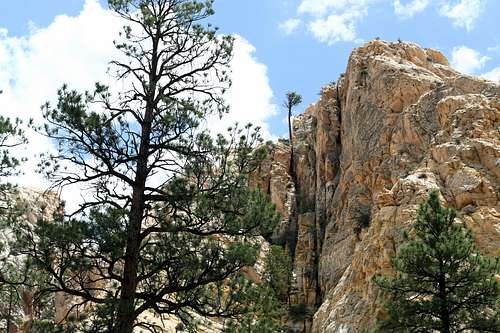
Upper Box Cliffs
Give yourself 4 to 7 hours depending on your direction and on how fast you hike. There are many ups and downs regardless of the direction of travel because of the many times you have to descend and ascend the stream banks. Expect to take a beating on your legs from the thick brush if you wear shorts.
The following map is an approximate route:
View The Box in a larger map
Camping

A Shady Campsite
Backcountry Camping
Bounteous campsites can be had in the canyon. The “halfway” area of the canyon has great camping sites. The ponderosa pines create good cover from the sun.
Dispersed Camping
Free campsites can be found all along Hell’s Backbone Road in either the forest or the lower hills and canyons.
Campgrounds
Blue Spruce Campground is a logistical “no-brainer” place to stay overnight before and/or after the hike. It is only a 1/2-mile beyond the Upper Box access area. The campground has pit toilets, seasonal potable water, plenty of space between neighboring campsites, tables and fire pits with grills. Firewood is cleaned up around the campsites, but a short walk off the beaten path reveals plenty of wood to collect for a fire. This campground does have bear boxes at each site. Yes, there are black bears in the area. The campground is situated in a beautiful environment of various pines and firs, which freshen the air. Pine Creek also flows behind each site, serenading weary hikers to sleep. For more information on this campground click here.
Posey Lake also has a campground, which would be the next closest place to stay. The author did not verify any accommodations. For more information on this campground click here.
Check campground status here.
In the author’s experience, the Blue Spruce campground was open before it was officially recognized on the website. The potable water may or may not be turned on before the official open date. Tip: Bring a roll of toilet paper, just in case it is not provided.
Please contact the forest service for further details
Escalante Interagency Office
PO Box 246
755 West Main
Escalante, UT 84726
435-826-5499
Escalante, UT
For those interested, the town of Escalante, UT has many motels, groceries, dining, supplies and outfitters available.
Water
The great thing about this canyon is that Pine Creek flows next to the trail the entire way. The stream originates high on the slopes of Boulder Mountain. The creek is cold and clear. It is clear enough that you can easily observe the small trout that inhabit it. Water could be easily filtered from it. Also, with so many creek crossings along the trail, it is not difficult to dunk your hat or shirt in the water to help keep your body cool.
 Life Sustainer
Maps

A Keeper of The Box
USGS Quads:
Posy Lake 1:24,000
Wide Hollow Reservoir 1:24,000
Escalante, UT 1:100,000
National Geographic Trails Illustrated: Currently nothing is available
Flora and Fauna
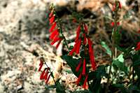
Firecracker Penstemon
This hike is located in what is known as the Transition Zone. The ponderosa pine is the flagship tree of this zone.
The creek banks are crowded with Gambel's Oaks. You will also see the intermingling of other pines, firs, and junipers. Douglas firs and spruces will be found near the top of the canyon.

Kellogg's Spurred Lupine
Big sagebrush is found in the lower portions of the canyon. Wildflowers of many varieties can be found along the entire hike.

Pale Trumpet
Large animals will include deer, mountain lion, and elk in the winter. Blue Spruce Campground informs visitors that they are in black bear country. Smaller critters will include porcupines, chipmunks and ground squirrels. Symphonies of songbirds fill the air with rapture. The ever-present crow will also be heard squawking overhead. Posey Lake is home to ducks and loons.

Lizard
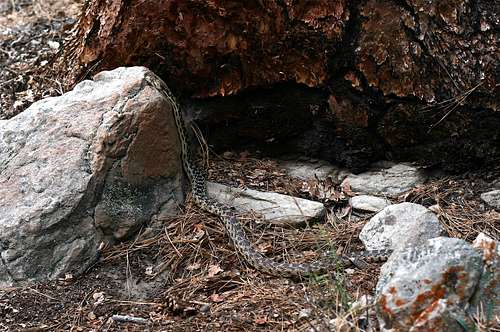
Gopher Snake
Lizards are everywhere. Snakes, including rattlesnakes live in this canyon. Pine Creek is stocked with rainbow and brown trout. The native cutthroat trout is also making a comeback in this stream. All the fish that the author spotted were anywhere from 4-8 inches. The ranger boasts that trout up to 11 inches can be found in the deeper holes near the campground. Posey Lake also has a large population of tricky trout where the author caught two 9-inchers on a spinner. A fly-fisherman should have a blast there.