HOW I GOT THERE
After doing some hikes and climbs in Ecuador since the day of my arrival to the country, Boriss and I planned to climb Illiniza Sur, one of the mountains that attracts me so much, but being on a call could make you change your plans or even to post-pone them for a while. (Weather isn't the best anyway, so I guess it was ok).
![Chuquiragua jussieui - Flor del Andinista]() Chuquiragua jussieui - Flor del Andinista
Chuquiragua jussieui - Flor del Andinista
Boriss got a phone call from the agency he was working at. This time he had to guide up to Guagua Pichincha (4781 m) for one day.
I had to take advantage of this trip. Being Guagua Pichincha known as an unsafe place for solo hikers, specially for woman (many rapes were reported in 2008 there) Boriss planned the way of taking me along with his clients on the trip.
Personally, I'd like to try to reach those summits above the 5,000 meters located along the endless Cordillera de los Andes in Ecuador, but I wouldn't mind to push for those summits with lower altitudes either. And mostly, if those are very active volcanoes like Guagua Pichincha... which entered in eruption process in 1999, covering the whole city of Quito with ash.
The climb
A new day started and Boriss and I left home at 7:30 am. Thick dark clouds rolled in and made us think that we will not climb much today uffff.
Well, we got to the agency at 8:40 am and picked our new climbing partners up. They were Ben, Dan, Steve and Duncan.. all of them from England who were trying to climb Guagua Pichincha, Illiniza Norte and Cotopaxi within a week.
Boriss drove the agency's jeep through the city during rush hour. It took us forever to cross the whole city from north to south. I didn't know how hard it could be to drive through this big city, people cross the streets anywhere, horns, shouts, cows, donkeys and goats on the streets.. completely chaos!
![On the way to Guagua]() On the way to Guagua.
On the way to Guagua.![Rucu Pichincha and Padre Encantado]() Rucu Pichincha and Padre Encantado
Rucu Pichincha and Padre Encantado
Finally, we got to Ungui's foothills where we rode for about 20 minutes until we got to the Lloa Valley. Once there we drove for about 20 more minutes uphill. It's possible to drive all the way up to Guagua Pichincha's refuge with a good 4WD, but our plan was to start an acclimatization program at 3,500 m. So, that's where our hike started.
We hiked on a dirt dusty road (about 6 km). The hike was nice, fun and pleasant. The day cleared off and we were able to see the nearby mountains such as Padre Encantado, Rucu Pichincha, Atacazo, Cayambe, Antisana, Ruminahui, Pasochoa, Corazon, Sincholagua and Cotopaxi.
![Padre Encantando from Guagua Pichincha]() Padre Encantando from Guagua Pichincha
Padre Encantando from Guagua Pichincha ![Rucu Pichincha from Guagua Pichincha]() Rucu Pichincha from Guagua Pichincha
Rucu Pichincha from Guagua Pichincha
We hiked up a very slow pace, so our friends could take advantage of the acclimatization process. We all got the refuge after 5 hours of steady hike. I kept staring at the maps and pictures placed on the refuge's walls. I learned all I wanted to know about Guagua Pichincha and its volcanic activity during the last decade.
We had lunch at the refuge's living room, joked and laughted for a while and then headed out and walked up to the crater rim, which looked pretty close from where we were standing at.
![The ridge of Guagua Pichincha]() Boriss (ECU) on his way to the Guagua Pichincha peak.
Boriss (ECU) on his way to the Guagua Pichincha peak.![Guagua Pichincha]() The peak with the cross 20 min from the refuge.
The peak with the cross 20 min from the refuge.
We walked for about 20 minutes, got to the crater rim and then to the second summit, where we took pictures with the metal cross and the Virgen del Cinto.
We had a short break and then we continued up to the main summit. The afternoon turned windy, but luckly it didn't rain. Ben started feeling the symptoms of AMS just 5 meters below the summit. We had to wait almost 15 minutes for him to get better. Once he felt better we started climbing up to the summit.
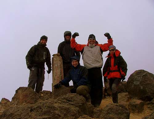
Got to the summit after 5 and a half hours of hiking. We hung out up there for a while and then headed down back to the refuge and then to the car. We got to the car just before sunset.. It was a long day for us, 12 km hiked in 8 hours, plus a couple more hours to get home. When we got back home, we were totally exhausted but happy of our achievement.
![Guagua Pichincha summit.]() The english clients and me on the summit of Guagua Pichincha - Photo by Boriss(ECU)
The english clients and me on the summit of Guagua Pichincha - Photo by Boriss(ECU)
Comments
No comments posted yet.