Green Lakes Trailhead to Tourist Creek
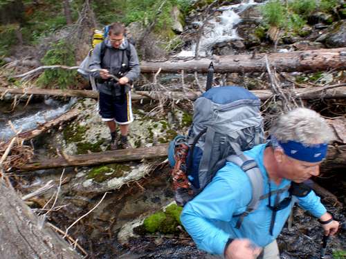
After leaving the parking lot which was 2/3rd's full of out-of-state-plates, we crossed the Green River bridge to begin our trek southeast along the lakes. Pepper spray remained holstered close at hand after we heard reports of two grizzlies attacking campers in this area five weeks earlier. We enjoyed a strong breeze hiking up river 9 miles to the bridge crossing. We decided to try bush wacking off-trail on the east side of the river instead of crossing the bridge and staying on the trail up to Three Forks Park. What a mistake. Pine beetle has left a thicket of deadfalls to negotiate over the 1.5 miles of thick forrest to Tourist Creek. We learned our lesson and on the way out easily waded the slow moving Green at Three Forks Park.
Tourist Creek Assault
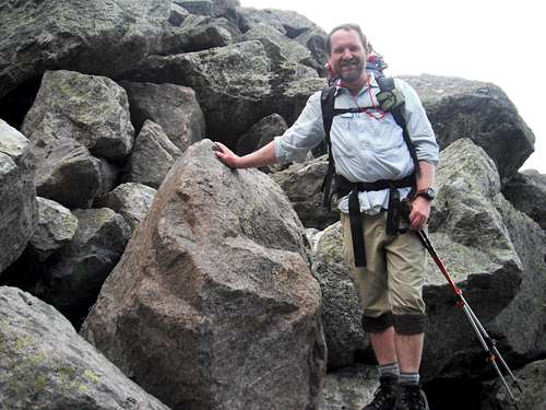
Tourist Creek drainage starts with dense old growth timber with downfall at every step. There are cairns from the base of the creek and provide a good route up to the boulder fields above tree line. Once in the boulders, keep adjusting left to right across the field so that you are climbing the optimum sized boulders. Smaller rocks and gravel are loose under foot while anything larger than a man can be too big to take steps up.
Tom stepped on this boulder and had it slide about 6-8 feet down hill while he road it down before bailing out. I'm just glad he didn't end up under it, or we would have had to put him out of his misery.
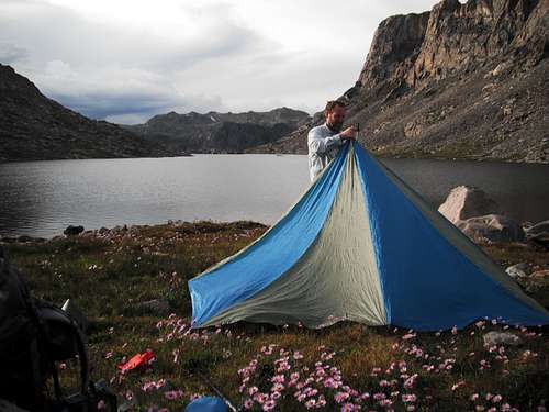
We got the tent up near the top of Tourist Creek drainage just in time as a long winded thunder storm pinnned us down for about 2 hours. This proved to be a well timed rest and refueling stop prior to the last 90 minutes of hiking to base camp at the south end of "Rocking Chair Lake", a name we made up to help it match the ambiance of "Tourist Creek". The day had consumed nearly 7 hours of hiking to gain 3.5 miles and three thousand vertical.
Summit Day
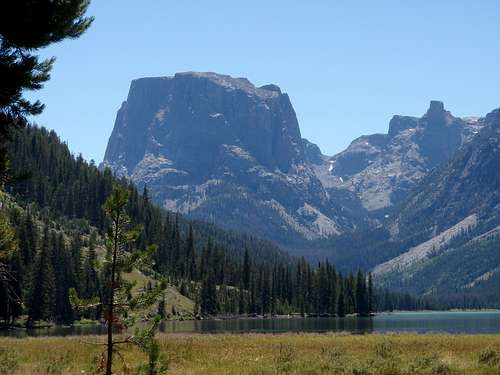
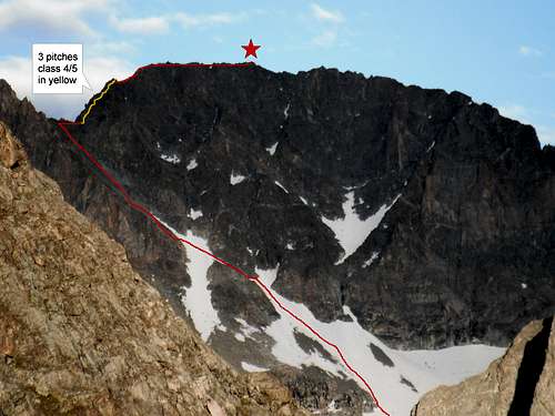
I took this photo of Gannett Peak from the southern edge of the Tourist/Wells creek divide just 5 minutes from base camp on the evening before summit day. We planned on getting up at 3:30 A.M. and find our way down the Wells creek side by headlamp. Finding the high traverse route by headlamp proved difficult and we defaulted to a descent to Scott Lake loosing both time and altitude.
After hiking along Scott Lake and following the creek to the upper Tarn Lake, we chose to stay on the right side of the lake (marked in red) and follow the shoreline to the boulders leading up the right side of the headwall to Minor Glacier. Our descending route (marked in yellow) was more direct. Live and learn!
We climbed into harness, crampons, and then roped up while standing at the bottom of Minor Glacier. Crossing the Glacier was easy with no hazards.
The snow ramp leading up to the couloir provided us with good firm snow and required a short rock crossing at the very top to turn left up to the snow covered lower couloir. Crampons and ice axes were left in the rocks after finishing with the last of the snow which had only covered the lower third of the couloir.
Ascending talus in the couloir proved easier if we stayed to the left hand side staying in larger more substantial rock. We had great views of Scott Lake drainage behind. This vantage also gave us excellent visibility to the southwest demonstating mostly clear skies without a trace of any thunderstorms. We decided to push ahead even though we were running late. 30 mph winds buffeted the slopes as we approached the saddle of the couloir.
Looking north from the saddle gave a view of Dinwoody Creek winding 25 miles south to the base of Dinwoody Glacier. That route looked appealing after having ascended the boulder fields of Tourist Creek the day before.
After enjoying views from the saddle, we made our way around the right side of a small prominence and prepared the rope for climbing the class 4/5 rock leading to the summit. It was then very apparent that the storm we had weathered the day before had deposited about 1.5" of graupel/snow on the upper surfaces of Gannett. Tom assured me that the hand holds were big enough to make this a non-issue, and immediately started to lead a route quickly up the North Ridge of Gannett. We followed using a running belay technique with Ben cleaning behind me. We quickly found ourselves next to Tom at the top of the rock climbing section looking up the ridge line, narrow snow patch on the left and a thin rock ridge on the right. We traversed the interface between the two mediums as we ascended the last 50-75 yards to the top.
![Ben Hisey Gannett Summit]()
![Tom Hisey Summitt Gannett]()
![Steve on Summit Gannett Peak]()
Ben filled out the summit register while I snapped photos of them standing on the summit. Tom had now added Gannatt to his list of high points. He has Mckinley, Rainier, Granite, Hood under his belt. Next year Borah?
Heading Down
The top rapel station was composed of 80% weathered looking runners and required a new addition. Ben is showing us his best side while descending the 2nd rapel station. There were no on-route rapel stations set up at this second level requiring extra time for Tom to install a couple of runners around a nice spire. We made good time descending the couloir and then donned crampons and roped up to descend the snow. Direct sun had softened the snow to allow kicking in across the couloir, and then plunge stepping much of the lower snow field.
![High traverse route Tourist Creek]()
This is a view from the top of the headwall looking down into Tarn Lake. We ascended the yellow track from Scott Lake in the morning, and descended the red track on the right taking a more direct line down. The red track used the High Traverse which appears as a nice ramp leading back up the dividing ridge to our base camp. We reached the Tarn in the dark and made it a short distance around the right hand side of the lake when we ran out of energy. It was 10 P.M. and we had been moving since 3:30 A.M. After a group vote, we decided to bivy on a grass patch along the lake. Despite relatively warm temps and minimal wind, we spent most of the night shivering between short naps and alternating sets of squats to keep warm.
High Traverse GPS Coordinates (Blue Track)Tarn->Divide
Track High Traverse 8/18/2010 6:34:01 AM 2:57:57 1.4 mi 0.5 mph
Header Position, Time, Altitude
Trackpoint N43 11.535 W109 40.927 8/18/2010 6:34:01 AM 10861 ft
Trackpoint N43 11.562 W109 41.038 8/18/2010 6:42:35 AM 10818 ft
Trackpoint N43 11.576 W109 41.088 8/18/2010 6:51:49 AM 10777 ft
Trackpoint N43 11.579 W109 41.165 8/18/2010 6:54:18 AM 10766 ft
Trackpoint N43 11.585 W109 41.229 8/18/2010 6:57:22 AM 10768 ft
Trackpoint N43 11.604 W109 41.296 8/18/2010 7:02:13 AM 10749 ft
Trackpoint N43 11.619 W109 41.394 8/18/2010 7:09:46 AM 10796 ft
Trackpoint N43 11.630 W109 41.504 8/18/2010 7:20:03 AM 10910 ft
Trackpoint N43 11.640 W109 41.618 8/18/2010 7:47:50 AM 11023 ft
Trackpoint N43 11.648 W109 41.703 8/18/2010 7:54:37 AM 11091 ft
Trackpoint N43 11.680 W109 41.765 8/18/2010 8:04:17 AM 11109 ft
Trackpoint N43 11.699 W109 41.836 8/18/2010 8:09:11 AM 11082 ft
Trackpoint N43 11.701 W109 41.921 8/18/2010 8:18:53 AM 11077 ft
Trackpoint N43 11.722 W109 41.992 8/18/2010 8:22:12 AM 11063 ft
Trackpoint N43 11.758 W109 42.061 8/18/2010 8:33:54 AM 11020 ft
Trackpoint N43 11.769 W109 42.122 8/18/2010 8:44:36 AM 11050 ft
Trackpoint N43 11.777 W109 42.198 8/18/2010 8:48:39 AM 11071 ft
Trackpoint N43 11.790 W109 42.285 8/18/2010 8:55:49 AM 11104 ft
Trackpoint N43 11.825 W109 42.322 8/18/2010 9:09:49 AM 11198 ft
Trackpoint N43 11.825 W109 42.237 8/18/2010 9:14:03 AM 11227 ft
Trackpoint N43 11.878 W109 42.156 8/18/2010 9:19:47 AM 11145 ft
Trackpoint N43 11.905 W109 42.131 8/18/2010 9:31:58 AM 11150 ft
At first light we began climbing the ramp of the High Traverse using the red route line (GPS coordinates from Tarn up to divide)and found easy walking on the left hand side along a narrow border of grass between the boulders to the right and hard rock to the left. It took a another 3 hours of scrambling that day to get back to base camp at about 10:30 A.M. The rest of that day was spent sleeping, eating, and resting.
Tom lead the way down the Tourist Creek gauntlet requiring 6 hours to descend 3.5 miles to the meadow floor.
Walking across the FLAT grassy meadow to the edge of the meandering Green River reminded us that there indeed is a God! We pulled off the boots and socks and zipped off the pants to prepare for wading the river. We chose a wide section of river in the middle of the meadow which had a sand bar stretching across 80% of the width of the river. The other 20% was waist deep. We found the trail in the timber on the other side of the meadow and hiked down about a mile before pitching camp for the night.
We broke camp the next morning and headed down trail with lighter packs and a supper highway of a trail. At one of the water breaks I noticed Tom's boots were falling apart at the seams and snapped a photo. Ben's heals had massive blisters requiring glacier gel. I had a stiff neck and a blister under my left shoulder strap. These were minor impairments considering the terrain we had negotiated and I thanked God for our good fourtune.
Tom carefully uncoverd his prize which remained submerged in the river since departing 6 days earlier. He was kind enough to share one of his Snake River Zonker Stouts as we lounged in the shade eating hard salmi, cheese, and crackers. Borah he asked?


Comments
Post a Comment