
-
 4705 Hits
-
 74.01% Score
-
 4 Votes
|
|
Route |
|---|---|
|
|
32.38630°N / 110.6633°W |
|
|
Hiking, Scrambling |
|
|
Spring, Summer, Fall, Winter |
|
|
Half a day |
|
|
Overview
 Nearing the summit from the northwest
This is a pleasant route of moderate length and gentle elevation gain. It follows a maintained trail up Bear Canyon to Bear Saddle, and then picks up a very discernable social trail up and over a few 7,000-ft humps to reach the summit of “Guthrie Mountain.” An easy class 2+ scramble near the summit spices up the route just a bit. A large summit cairn in the trees leaves little doubt when you’ve made the top. The nearby scenery as well as distant views are pleasant, and this is a great place to escape the Tucson heat in warmer weather.
Roundtrip Distance: 6 miles
Elevation Gain: 1,300 feet
Getting There
 Green Trail #21
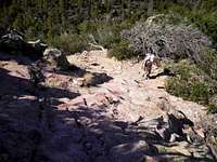 Easy scrambling below summit
The Catalina Highway (also referred to by some in town as the Mount Lemmon Highway and by the Forest Service as the General Hitchcock Highway) will take you to the trailhead. The General Hitchcock Picnic Area & Campground, which serves as the trailhead for this route, can be reached within an hour of downtown Tucson.
Take Tanque Verde (often pronounced “TANKy VURdy by the locals) diagonally across the northeast edge of town to East Catalina Highway. Follow East Catalina Highway North for about 4.5 miles to the Forest Service boundary. Here the road becomes the General Hitchcock Highway…or the Catalina Highway…or the Mount Lemmon Highway.
The turnoff for the trailhead is on the right at mile 12 of the highway, where the road makes a sharp, sweeping hairpin turn pointing northeast. It is the turnoff just past the Middle Bear Canyon picnic area. The trailhead is at the end of the side road near the campground.
| Note that the highway is paved, but longer vehicles (22 feet or greater) or those towing a trailer may have difficulty negotiating tight curves. Be careful not to park in spaces reserved for those staying in walk-in campsites. |
Route Description
 Easy scramble toward summit
 Summit Cairn
• Finding Green Mountain Trail #21 from this parking cul de sac is a bit confusing at first. Progress east-ish toward the back of the camping area. Look for a sign indicating Green Mountain Trail 21, past a large water tank. Soon enough the trail will look like an interstate highway and you will wonder how you ever managed to have difficulty locating it.
• The lower reaches of the trailhead through the (usually dry) creek bed in Bear Canyon are shaded and lovely.
• Soon enough, you will leave the shade of the creek bed behind and begin climbing through stunted Ponderosa Pine, juniper, scrub oak and Manzanita. In many places, the trail crosses bear rock making for nice views (but keep an eye on the cairns to ensure you stay on-trail).
• After about 2 miles of on-trail travel, you will reach Bear Saddle. Look to your right for a hand-done sign toward “Guthrie Mountain.” From here it is 1 undulating mile to the summit.
• Leave the Green Mountain Trail on the well-traveled but unmaintained footpath to “Guthrie Mountain.”
• The footpath heads first almost due-east across a sub-saddle and over a 7,000 foot point, then turns almost due-south across another sub-saddle and over another 7,000 foot point.
• Finally, the route travels southeast down into a saddle then up toward the summit of “Guthrie Mountain.” Some easy scrambling is encountered below the summit of “Guthrie Mountain” on the northwest ridge.
• The true summit is in the trees and does not afford views, but many areas surrounding the summit provide dynamite views of the surrounding mountains and valleys.
Essential Gear
 Summit from the northwest
 Follow the drainage
• Standard hiking gear and protection from the weather, appropriate to the season, would be sufficient for this hike.
• The Green Trails Maps #2886S Santa Catalina Mountains map will help you navigate the trail system to the summit of this peak.