
-
 2976 Hits
-
 76.53% Score
-
 7 Votes
|
|
Mountain/Rock |
|---|---|
|
|
49.13561°N / 7.82286°E |
|
|
Sport Climbing, Toprope, Scrambling |
|
|
Spring, Summer, Fall |
|
|
984 ft / 300 m |
|
|
Overview
 Strackfelsen from south-west Strackfelsen from south-west |
The village Busenberg is located right at the centre of the Wasgau climbing area. In addition it is located in the centre of a ring of sandstone cliffs and thus offers one of the best starting points for the exploration of many formations. Most prominent is Drachenfels Castle with its climbing tower Schulerturm but with Heidenpfeiler and Buhlsteine it has some of the tallest and most popular climbing destinations of the whole area. The south and west of the village is less explored and you can find smaller but equally interesting towers and cliffs there.
Close to the highway between Busenberg and Schindhard there are two formations on either side of the road: Eilöchelfelsen to the west and Strackfelsen to the east. The latter is a typical Südpfalz formation: a long stretched massif with a separated tower up front. Unlike many other formations it can be rather easily climbed (scrambled) up to. There are half a dowen UIAA II routes to the summit. However, its main interest lies in the climbing routes across its faces.
 |  |  |  |
For one, Strackfelsen is one of the few Südpfalz formations for which there is only one recorded first ascent by Hans Laub. Its climbing history started late in 1966, when Edda, Klaus and Jürgen Henßler established about half a dozen routes rated IV and V. In the early seventies there were a few FAs but the main action and the hardest routes were created in the late 1990s and early 2000s. The hardest routes are Flugschule and Flugschüler, both rated at VIII and created by Jens Richter and Falk Henschke respectively. Also, Strackfelsen has a surprising number of aid lines (7).
 |  |  |
However, Strackfelsen is most famous for something else: You can see the Eilöchelfelsen Rock window from its top. At the right time of year and the right time of day you can almost see the sun set through the keyhole:
  |
Getting There
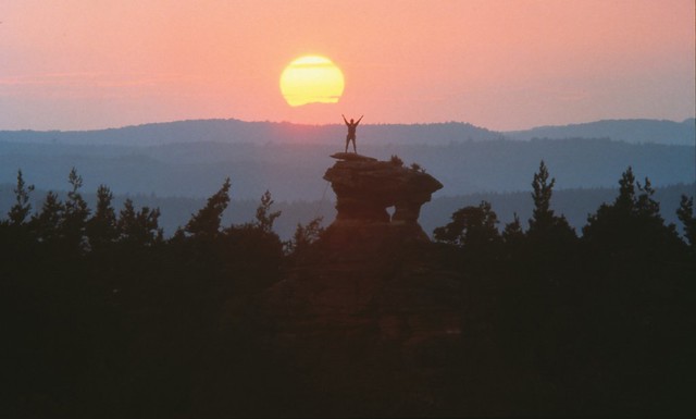
 Summit panorama Strackfelsen
There is a parking lot at the road between Busenberg and Schindhard, about 200m to the west of the formation. It also serves nearby Eckturm and Eilöchelfelsen. You can reach Busenberg as follows:
From Frankfurt
There are two possible routes which both take equally long- Via Ludwigshafen
- From Frankfurt take motorway A5 southward to Darmstadt.
- There change to A67 south.
- At Viernheimer Dreieck turn onto A6 west. Leav
- e it at Frankenthaler Kreuz for A61 south.
- At Mutterstädter Kreuz take A65 south until you reach Landau.
- At Landau turn on B10 west.
- At Hinterweidental turn onto B427 south which will take you through Dahn to Busenberg
- Via Kaiserslautern
- From Frankfurt take motorway A3 west
- At Mönchhofdreieck turn onto A67 south
- At Rüsselsheimer Dreieck take A60 west
- At Kreuz Mainz Süd take A63 south
- At Kreuz Kaiserslautern turn onto A6 west
- At Kreuz Landstuhl turn onto A62 south
- At Pirmasens turn onto B10 east
- At Hinterweidental take B427 south to Busenberg
From Stuttgart
- Take motorway A8 to Karlsruhe
- At Karlsruher Dreieck turn north onto A5
- Tke the next exit to head for A65
- At Kandel you can leave onto B427 which will lead you directly to Busenberg.
Red Tape
The sandstone of Südpfalz forms lots of caves and overhangs. Though this makes it most interesting for climbers, two species of birds of prey compete for this habitat: the peregrine falcons and the eagle owls. Both are endangered and wherever there is a eagle owl pair found nesting in the sandstone the crag will immediately be closed. Generally this closure lasts from the beginning of each year through Aug. 1st. If breeding is not successful the closures will be canceled even before that date. For a list of closures see the Closure List of PK.The use of magnesia is not allowed in the whole Südpfalz region. This is rather a directive or an arrangement than an outright law. Thus you probably will get away with using it but do so only when absolutely necessary. Magnesia closes the pores which you find in the sandstone and together they form a smooth surface which will get very slippery in wet conditions. The rule of thumb is to use magnesia in the highest difficulty sections and only extremely sparingly.
A list of guidelines can be found here (in German).
Accommodation
In Busenberg you can find pensions, apartments and restaurants. Have a look at the official site for more info. There is a campground at Neudahner Weiher, north of Dahn, a second one west of Dahn. Both are about 10 km to the north-west of Busenberg. A third campground can be found at Bruchweiler-Bärenbach, about 7km to the south-west.Weather Conditions
Maps & Books
Maps
As for maps there is a good overview map (1:50000) by Kompass Verlag but the best ones are the official topographic maps by the state government of Rheinland Pfalz, scaled 1:50000, 1:25000 and 1:5000. All official maps can be found on the web page of Landesvermessungsamt Rheinland Pfalz
1:50000
- Naturpark Pfälzer Wald
Kompass Map WK766
ISBN: 3-85491-523-3
- Pirmasens Süd
LVA RLP Map L6910
ISBN: 3-89637-193-2
1:25000
- Dahn
LVA RLP Map 6812
ISBN: 3-89637-147-9
Books
There are a number of climbing guidebooks on the region of Südpfalz. The best ones, however, have been published privately and are sold only in selected bookshops of the region.
- Hiking
- Pfälzerwald
B. & J.-Th. Titz
Rother Verlag
ISBN: 3-7633-4268-0 - Klettern im Buntsandstein
U. Daigger, H.-J. Cron
Westpfälzische Verlagsdruckerei St. Ingbert
ISBN: 3-00-0155457-4
- Pfalz - Klettern im Buntsandstein des Pfälzer Felsenlands
J. Richter, S. Tittel
Panico Alpinverlag
ISBN: 978-3-936740-41-7
- Pfalz ++, Klettern im Buntsandstein
R. Burkard, P. Weinrich
Published privately
- Klettern im Naturpark Pfälzerwald
Naturfreunde Lambrecht
Published privately - Pfalz & Nordvogesen en bloc
A. Wenner, Y. Corby, I. Bald
Panico Verlag
ISBN: 3-936740-19-4
 Climbing Guidebook |
Climbing