
-
 3005 Hits
-
 78.1% Score
-
 9 Votes
|
|
Route |
|---|---|
|
|
46.47665°N / 10.04476°E |
|
|
Download GPX » View Route on Map |
|
|
Hiking, Skiing |
|
|
Summer, Fall |
|
|
Most of a day |
|
|
Hike |
|
|
Overview
 Piz la Stretta seen from its south-eastern fore summit
Seen from the Swiss side, Piz la Stretta (also Monte Breva) stands above the end of Val da Fain (the hay valley) above the saddles Passo la Stretta and Fuorcla Chamuera. Both of the saddles can be used to ascend the mountain, though at different difficulties. While the hike through Fuorcla Chamuera will turn into a steep scramble through the summit's west face, the route from Passo la Stretta uses the gentle slopes of the south-east ridge of the mountain and thus is rather easy for the quite considerable elevation of the mountain.
This page describes the route through Val da Fain to Sella la Stretta and up the south-east ridge. The first part runs along dirt roads until you reach Alp la Stretta, from where a narrow path takes you to the saddle. Quite a number of switchbacks will take you up the lower south ridge until you cross the broad south-east ridge to the summit.
Getting There
 Looking into Val da Fain from the trailhead near Diavolezza
There are two trailheads for the route. The longer hike starts at the Diavolezza cable-car station on the Bernina Pass Road and follows all of Val da Fain. The shorter hike starts in Valle della Forcola on the Livigno side at the cabin Baitel del Gras degli Agnelli and heads directly for Passo la Stretta. Another possible trailhead would be the customs house at Forcola di Livigno.
All three trailheads can be easily reached from the Bernina Pass Road. Diavolezza can be found directly on the road some 4km beneath the highest point. Both Livigno trailheads are on the road from Bernina Pass to Livigno, right after you cross the border and within one km of each other.
The description below starts at Diavolezza. Nota Bene: Diavolezza has its own train station so you don't actually need a car.
Route Description
 Lake at Passo la Stretta
- General:
- Start altitude: 2093m
- Summit altitude: 3104m
- Prevailing exposure: E
- Type: Hike
- Protection: None
- Start altitude: 2093m
- Effort: 3 - 1300m elevation gain and 22km distance
- Power: 2 - Long but easy
- Psyche: 1 - Easy
- Difficulty: 1 - Easy
- Orientation: 2 - Generally easy and marked. With a slight snow cover you have to find your own route in the topmost section
From the huge parking lot near the Diavolezza cable-car station head for the western exit from B29, the Bernina Pass Road. Cross the road towards a narrow path, which follows the road westwards for a few hundred metres, then descends into the valley of the Bernina Creek. Cross the creek on a bridge and you are at the mouth of Val da Fain.
 |  |  |
Follow the dirt road into the valley and stay on the left hand road at an intersaction after 500m. The right hand road dead ends at Alp Bernina a few hundred metres ahead. Also stay on the road when after about 1 km a path turns off to Fuorcla Pischa to the left. The road follows the huge bend of the valley, gradually rising. After a while Piz Alv on the right hand side of the valley retreats and offers the first view to Piz la Stretta / Monte Breva.
At Alp la Stretta the road ends. Another path turns off to the left to Fuorcla Chamuera. Take the path ahead instead which leads you at roughly the same elevation to the swamp like region near Passo la Stretta. Some nice lakes can be found right beside the pass. Cross the pass and descend to the Livigno side for a short section until you reach a path crossing.
 |  |  |
Take the northern part (sign: Somp i Crap Nèir, Lago del Monte), which starts to wind up Piz la Stretta's south ridge in many switchbacks. It heads for a plateau-like shoulder, where you find anothe path intersection. The right hand path leads northwards to Lago del Monte while the left hand path heads up to Piz la Stretta. At first you stay beneath the SSE ridge, heading for a small saddle, from where a quick steep section leads you to a round topped foressummit of Pizz la Stretta (3005m).
 |  |  |
Descend from the fore summit into a saddle (there''s a small lake there), then start to tackle the final SSE ridge. It is broad and not very steep, however the ground is soft and thus very tiring. The summit is broad as well, like a little plateau.
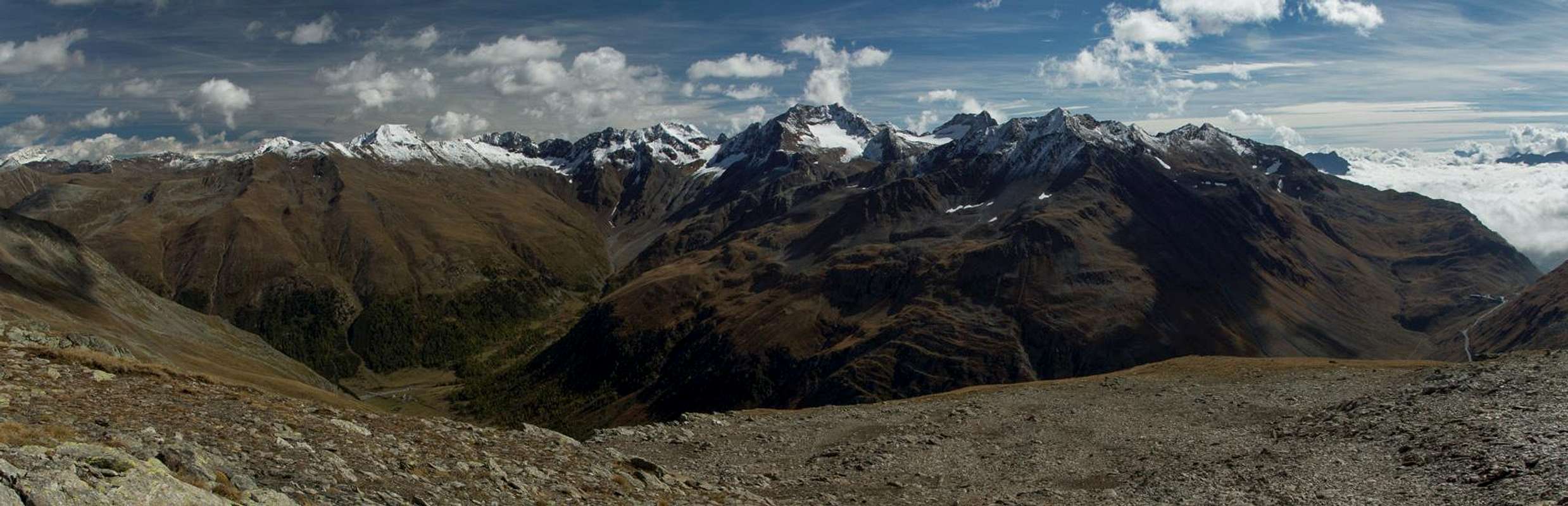
Summit panorama towards the east
Return the way you came or descend throgh the west face to Fuorcla Chamuera and from there back to Alp la Stretta.