
-
 2125 Hits
-
 79.04% Score
-
 10 Votes
|
|
Route |
|---|---|
|
|
59.17430°N / 85.08187°W |
|
|
Hiking, Scrambling |
|
|
Spring, Summer, Fall |
|
|
Most of a day |
|
|
Almost all Class 1 and 2 with a Class 3 summit pinnacle |
|
|
Overview
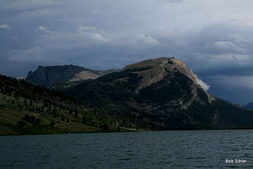
With the Northwest Slopes route visible. Find your way to the ridge crest left of the obvious cliffs.
First, consider the solitude; there’s just about no chance you will see someone else off the trail out here even though the trail you use on the approach is part of one of the most heavily used backcountry corridors in the Wind River Range.
And then consider the views. Seemingly so close yet really at least two days’ travel away because of canyons, streams, ridges, and passes is Gannett Peak, highpoint of the range and of all of Wyoming. Far to the northwest but easily visible on a clear day is the Cathedral Group of the Tetons, which includes the Grand Teton, Wyoming’s most famous peak (Mount Moran, another famous American landmark, is visible as well). From the Tetons, let your eyes drift east and north across the sprawling Mount Leidy Highlands to several peaks of the Absaroka Range’s Togwotee Pass area: Angle Mountain, Breccia Peak, Mount Sublette, Sublette Peak, and the Pinnacle Buttes (SP has pages for all of these).
In the more immediate vicinity are spectacular crags and cliffs of the northern Winds. Among them is Squaretop Mountain, practically right in your face and also a famous Wyoming landmark. And more than 3000’ directly below you, the Green River, which rises in the mountains out here and doesn’t end until its confluence with the Colorado River deep inside Utah’s Canyonlands National Park, winds through meadows and empties into the upper of the two Green River Lakes, which is stunningly colored by silt from the Mammoth Glacier and other smaller bodies of ice. The stream retains that color as it leaves the lake and flows into the lower and more often-photographed of the lakes, where the milky stream waters are quickly absorbed by the deep blue waters of that lake. From the summit, it is easy to see the striking contrast between the two lakes.
The solitude and all the views are the highly rewarding payoff for getting to the summit of White Rock Mountain. It is one of those mountains not for climbers but for those who seek to merge their spirits with the wonders of the mountainous world.
And the route described here is probably the most direct way to get there.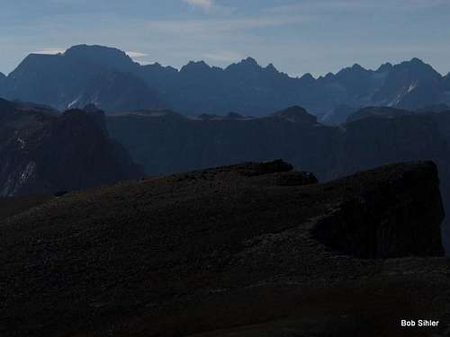
Roof of the Winds

Green River Lakes

Summit block
Getting There
These directions are copied from the Bridger-Teton National Forest site: "To reach the trailhead from Pinedale, drive 7 miles west on US Highway 191, turn right (north) on Wyoming Highway 352 and drive north to the National Forest boundary where the pavement ends (about 30 miles). Continue north on Forest Road 600, staying on the right side of the river. After 17 miles the road terminates at the campground and trailhead."
Notes: It is really more like 45 miles total (not a big difference), and the pavement actually ends at about 25 miles. In spots, the road is rough beyond that, but it is still passable to most low-clearance vehicles.
Route Description
In all, this is about an 11-mile day with about 3500' of elevation gain.Follow the trail downhill from the parking area to a nice bridge crossing the Green River shortly after its exit from the lake. Then turn right and follow the trail along the west shore of the lake. There are some gentle ups and downs, but overall there is little elevation gain, and ultimately you end up on the lakeshore level again.
![Leave Trail Here]()
Take the use trail on the left toward the trees and then start working up the northwest slopes. Look for game trails that will all but eliminate any bushwhacking.
![Northwest Slopes]()
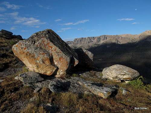
![Glacial Erratics on Northwest Slopes]()
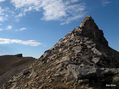
![White Rock Mountain Summit Pinnacle]()
![White Rock-- Northwest Slopes]()
The approximate line of the route up. Once you reach the ridge, the way is obvious. Getting to the ridge, look for game trails that make the bushwhacking virtually painless.Wind River Range, WY
About two miles from the trailhead is the intersection with the Clear Creek Trail. Keep straight (south).
Very soon after the junction is a crossing of Clear Creek. There is a bridge as well as a ford (the latter intended for stock).
Not long past that crossing, you want to leave the trail and start heading for the northwest slopes. Ideally, leave at about the spot depicted below; it will give you the best chance of finding the network of game trails that can get you all the way to the crest of the ridge with very little actual bushwhacking. But if you do have to bushwhack, it is not hard to keep it pretty painless.

Take the use trail on the left toward the trees and then start working up the northwest slopes. Look for game trails that will all but eliminate any bushwhacking.
Once you get to the crest of the ridge, the rest of the way is obvious. Steep but easy hiking gets you across high meadows and through one short section of trees to the summit pinnacle. For the best views, stay close to edge so you can enjoy the beautifully colored upper lake and river in addition to the ever-expanding views.
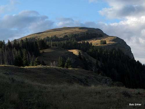
The summit pinnacle rises about 100', but the true Class 3 scrambling is less than that. It all culminates in a small, airy summit block that would come as a complete surprise on a peak like this one if not for the fact that you can see the pinnacle from the trailhead. However, back there, you can only hope that it is as good as it looks. Fortunately, it is.
Map

The approximate line of the route up. Once you reach the ridge, the way is obvious. Getting to the ridge, look for game trails that make the bushwhacking virtually painless.Wind River Range, WY